Lake of Menteith
Lake of Menteith, also known as Loch Inchmahome (Scottish Gaelic: Loch Innis Mo Cholmaig), is a loch in Scotland located on the Carse of Stirling, the flood plain of the upper reaches of the rivers Forth and Teith, upstream of Stirling.[1][2]
| Lake of Menteith | |
|---|---|
 Looking towards Port of Menteith | |
 Lake of Menteith | |
| Coordinates | 56.1744°N 4.2921°W |
| Type | freshwater loch |
| Primary outflows | River Forth |
| Max. length | 2.4 km (1.5 mi)[1] |
| Max. width | 1.6 km (1 mi)[1] |
| Surface area | 252 ha (620 acres)[2] |
| Average depth | 6.02 m (19.75 ft)[1] |
| Max. depth | 23 m (77 ft)[1] |
| Shore length1 | 9.7 km (6.0 mi) [2] |
| Surface elevation | 18 m (59 ft)[2] |
| Islands | Inchmahome, Dog Isle, Inch Talla |
| 1 Shore length is not a well-defined measure. | |
Name
Until the early 19th century, the more usual Scottish name of Loch of Menteith was used. On the Blaeu Atlas of Scotland, 1654, it is named as Loch Inche Mahumo. The only settlement of any size on the Lake of Menteith is Port of Menteith.[3]
Geography
There are a number of small islands in the loch. On the largest, Inchmahome, is Inchmahome Priory, an ancient monastery. The priory served as refuge to Mary, Queen of Scots, in 1547. She was only four years old at the time and stayed for three weeks after the disastrous Battle of Pinkie Cleugh in September of that year. The Loch is not particularly deep and can freeze over completely in exceptionally cold winters. If the ice becomes thick enough — at least 7 inches (18 cm)[4] — an outdoor curling tournament called The Bonspiel or the Grand Match is held on the loch. The event can attract thousands of curlers despite its rarity. The last Grand Match was held in 1979. The planned 2010 Bonspiel was abandoned on health and safety grounds.[5]

The Lake of Menteith is often thought of as the only body of water in Scotland that is referred to as a lake. Actually, there are others, some of which are artificial bodies: Pressmennan Lake, the Lake of the Hirsel, Lake Louise (within the grounds of Skibo Castle), Raith Lake in Kirkcaldy,[6] Upper Lake and Kelly Lake (both near Haddo House), Pitfour Lake, and Cally Lake (near Gatehouse of Fleet). There is also a sea bay near Kirkcudbright known as Manxman's Lake. Nearly all other major bodies of water in Scotland are known as lochs.
This unusual name is believed to be due to a corruption by 16th-century Dutch cartographers of the Lowland Scots Laich o Menteith, where "laich" simply means "low place". Alternatively the name change which took place when the area was first mapped by the UK Government's Ordnance Survey in 1838 was the result of the Lake being referred to as a Lake by prominent literature at that time.
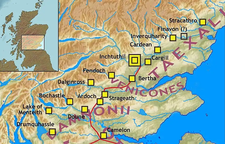
Malling Roman Fort
There was a Roman Fort associated with the Gask Ridge to the west of the lake. It was found by David Wilson[7] and Kenneth St Joseph in 1968 when they were conducting an aerial survey of Flanders Moss.[8] Following the aerial photography, ground measurements of resistance and magnetic susceptibility were taken.[9] The site may have been known as "Lindon" to the Romans.[10]
In popular culture
In 2020, the lake was featured in the BBC programme Springwatch presented by wildlife photographer Gordon Buchanan.[13]
External links
References
- John, Murray; Lawrence, Pullar (1910). Bathymetrical Survey of the Fresh-Water Lochs of Scotland, 1897-1909 Lochs of the Forth Basin Volume II - Lake of Menteith. National Library of Scotland: National Challenger Officer. p. 16. Retrieved 12 May 2018.
 This article incorporates text from this source, which is in the public domain.
 - "Lake of Menteith". British Lakes. Retrieved 12 May 2018.
- "Why is the Lake of Menteith a lake and not a Loch?". The Scots Magazine. D.C. Thomson. 74: 374. 1960.
- "Curlers prepare for 'Grand Match'". BBC News. 5 January 2010. Retrieved 5 January 2010.
- "Grand Match off over safety fears". BBC News. 8 January 2010. Retrieved 9 January 2010.
- "Raith Lake Trout Fishery". Raithlake.com. Retrieved 2012-11-06.
- "AARG Conversation N o 3: David Wilson and Rog Palmer: 29 July 1998" (PDF). AARGnews 17. September 1998. Retrieved 30 June 2018.
- "Menteith, Malling Glen Fort and Marching Camps". Roman Britain. Retrieved 30 June 2018.
- "Malling". Canmore. Historic Environment Scotland. Retrieved 30 June 2018.
- "Gazetteer". Roman Gask Project. Retrieved 30 June 2018.
- "Gask Ridge". Scribble Maps. Retrieved 9 June 2018.
- "Gask Ridge Map". HeritageDaily. Retrieved 9 June 2018.
- "Springwatch:Episode 8". Springwatch. Retrieved 7 June 2020.
