Lanark Highlands
Lanark Highlands is a township in eastern Ontario, Canada in Lanark County. The township administrative offices are located in the village of Lanark.
Lanark Highlands | |
|---|---|
| Township of Lanark Highlands | |
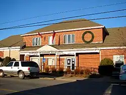 Municipal office in Lanark | |
 Lanark Highlands Location in Southern Ontario | |
| Coordinates: 45.088°N 76.517°W | |
| Country | |
| Province | |
| County | Lanark |
| Incorporated | July 1, 1997 |
| Government | |
| • Type | Township |
| • Reeve | Peter McLaren |
| • Governing Body | Lanark Highlands Township Council |
| • MP | Scott Reid (CPC) |
| • MPP | Randy Hillier (OPC) |
| Area | |
| • Land | 1,048.83 km2 (404.96 sq mi) |
| Population (2016)[2] | |
| • Total | 5,338 |
| • Density | 5.1/km2 (13/sq mi) |
| Time zone | UTC-5 (EST) |
| • Summer (DST) | UTC-4 (EDT) |
| Postal code | K0G 1K0 |
| Area code(s) | 613 |
| Website | www.lanarkhighlands.ca |
History
The current township was incorporated on July 1, 1997 by amalgamating the former townships of Darling, Lanark, and the previously combined township Lavant, Dalhousie and North Sherbrooke with the village of Lanark.
Communities
The township comprises the communities of Arklan, Boyds, Brightside, Bullock, California, Cedardale, Clyde Forks, Clydesville, Dalhousie Lake, Elphin, Flower Station, Folger, French Line, Halls Mills, Halpenny, Hood, Hopetown, Joes Lake, Lammermoor, Lanark, Lavant, Lavant Station, Lloyd, Marble Bluff, McDonalds Corners, Middleville, Pine Grove, Poland, Quinn Settlement, Rosetta, Tatlock, Watsons Corners, and White, as well as the ghost town of Herrons Mills.
 Lanark
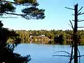 Lavant
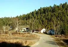 Lavant Station
 Poland
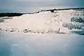 Marble mines near Tatlock
Demographics
| Canada census – Lanark Highlands community profile | |||
|---|---|---|---|
| 2016 | 2011 | 2006 | |
| Population: | 5,338 (+4.1% from 2011) | 5,128 (-1.0% from 2006) | 5,180 (+8.0% from 2001) |
| Land area: | 1,048.83 km2 (404.96 sq mi) | 1,048.19 km2 (404.71 sq mi) | 1,033.30 km2 (398.96 sq mi) |
| Population density: | 5.1/km2 (13/sq mi) | 4.9/km2 (13/sq mi) | 5.0/km2 (13/sq mi) |
| Median age: | 51.2 (M: 51.1, F: 51.3) | 45.6 (M: 45.4, F: 45.9) | |
| Total private dwellings: | 3,315 | 3,182 | 3,036 |
| Median household income: | $67,669 | $52,974 | |
| References: 2016[3] 2011[4] 2006[5] earlier[6] | |||
| Year | Pop. | ±% |
|---|---|---|
| 2001 | 4,795 | — |
| 2006 | 5,180 | +8.0% |
| 2011 | 5,128 | −1.0% |
| 2016 | 5,338 | +4.1% |
| [7][1][2] | ||
See also
References
- "Lanark Highlands census profile". 2011 Census of Population. Statistics Canada. Retrieved 2012-02-13.
- "Census Profile, 2016 Census: Lanark Highlands, Township". Statistics Canada. Retrieved June 19, 2019.
- "2016 Community Profiles". 2016 Canadian Census. Statistics Canada. February 21, 2017. Retrieved 2019-06-19.
- "2011 Community Profiles". 2011 Canadian Census. Statistics Canada. July 5, 2013. Retrieved 2012-02-13.
- "2006 Community Profiles". 2006 Canadian Census. Statistics Canada. March 30, 2011. Retrieved 2012-02-13.
- "2001 Community Profiles". 2001 Canadian Census. Statistics Canada. February 17, 2012.
- Statistics Canada: 1996, 2001, 2006 census
External links
Places adjacent to Lanark Highlands | |
|---|---|