List of township municipalities in Ontario
A township is a type of municipality in the Canadian province of Ontario. They can have either single-tier status or lower-tier status.
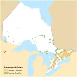
Ontario has 200 townships[1] that had a cumulative population of 990,396 and an average population of 4,952 in the 2011 Census.[2] Ontario's largest and smallest townships are Centre Wellington and Cockburn Island with populations of 26,693 and 0[N 1] respectively.[2]
History
Under the former Municipal Act, 1990, a township was a type of local municipality.[4] Under this former legislation, a locality with a population of 1,000 or more could have been incorporated as a township by Ontario's Municipal Board upon review of an application from 75 or more residents of the locality.[4] It also provided that a township could include "a union of townships and a municipality composed of two or more townships".[4]
In the transition to the Municipal Act, 2001, these requirements were abandoned and, as at December 31, 2002, every township that:[5]
- "existed and formed part of a county, a regional or district municipality or the County of Oxford for municipal purposes" became a lower-tier municipality yet retained its name as a township; and
- "existed and did not form part of a county, a regional or district municipality or the County of Oxford for municipal purposes" became a single-tier municipality yet retained its name as a township.
The current legislation also provides lower and single-tier municipalities with the authority to name themselves as "townships", or other former municipal status types such as "cities", "towns" or "villages", or generically as "municipalities".[6]
Township municipalities in Ontario
Former township municipalities
| Former township | Change date | Change event | Current status | Remarks |
|---|---|---|---|---|
| Barrie Island[8] | January 1, 2009 | Dissolution | — | Amalgamated into Gordon/Barrie Island |
| Dack[9] | January 1, 2003 | Dissolution | — | Amalgamated into Charlton and Dack |
| Delhi[10] | January 1, 2001 | Dissolution | — | Amalgamated into Norfolk County |
| Dymond[9] | January 1, 2004 | Dissolution | — | Amalgamated into Temiskaming Shores |
| Glanbrook[11] | January 1, 2001 | Dissolution | — | Amalgamated into Hamilton |
| Gordon[8] | January 1, 2009 | Dissolution | — | Amalgamated into Gordon/Barrie Island |
| Goulbourn[12] | January 1, 2001 | Dissolution | — | Amalgamated into Ottawa |
| Marmora and Lake[9] | March 14, 2001 | Status change | Municipality | |
| Michipicoten[8] | June 5, 2007 | Status and name change | Municipality | Name changed to Wawa |
| Norfolk[10] | January 1, 2001 | Dissolution | — | Amalgamated into Norfolk County |
| North Grenville[9] | July 14, 2003 | Status change | Municipality | |
| North Himsworth[9] | June 2, 2002 | Status and name change | Municipality | Named changed to Callander |
| Osgoode[12] | January 1, 2001 | Dissolution | — | Amalgamated into Ottawa |
| Rideau[12] | January 1, 2001 | Dissolution | — | Amalgamated into Ottawa |
| Shedden[9] | October 1, 2004 | Status and name change | Town | Name changed to Spanish |
| Shuniah[13] | January 2, 2011 | Status change | Municipality | |
| West Carleton[12] | January 1, 2001 | Dissolution | — | Amalgamated into Ottawa |
| West Grey[9] | December 2, 2002 | Status change | Municipality | |
See also
Notes
- Actual population may not be 0 as Statistics Canada, to protect privacy, rounds population to the nearest 5 in the event a geographic area's actual population is less than 15.[3]
References
- "List of Ontario Municipalities". Ontario Municipal Affairs and Housing. September 21, 2012. Archived from the original on February 28, 2013. Retrieved January 3, 2013.
- "Population and dwelling counts, for Canada, provinces and territories, and census subdivisions (municipalities), 2011 and 2006 censuses (Ontario)". Statistics Canada. May 28, 2012. Retrieved January 3, 2013.
- "Census Profile: Cockburn Island, TP, Ontario (Census subdivision) – 1. 2011 and 2006 population". Statistics Canada. March 1, 2013. Retrieved June 27, 2013.
- "Municipal Act, R.S.O. 1990, Chapter M.45". Service Ontario. Retrieved June 29, 2013.
- "Municipal Act, S.O. 2001, Chapter 25". Service Ontario. Retrieved June 29, 2013.
- "The Municipal Councillor's Guide". Ontario Ministry of Municipal Affairs and Housing. Retrieved June 29, 2013.
- "Corrections and updates: Population and dwelling count amendments, 2011 Census". Statistics Canada. February 14, 2013. Retrieved February 15, 2013.
- "Interim List of Changes to Municipal Boundaries, Status, and Names From January 2, 2006 to January 1, 2011 (Table 1 – Changes to census subdivisions in alphabetical order by province and territory)" (XLS). Statistics Canada. August 18, 2013. Retrieved August 18, 2013.
- "Interim List of Changes to Municipal Boundaries, Status, and Names From January 2, 2001 to January 1, 2006 (Table 1 – Changes to census subdivisions in alphabetical order by province and territory)" (XLS). Statistics Canada. August 18, 2013. Retrieved August 18, 2013.
- "Town of Norfolk Act, 1999, S.O. 1999, Chapter 14, Schedule E". Service Ontario/Legislative Assembly of Ontario. Retrieved August 18, 2013.
- "City of Hamilton Act, 1999, S.O. 1999, Chapter 14, Schedule E". Service Ontario/Legislative Assembly of Ontario. Retrieved August 18, 2013.
- "City of Ottawa Act, 1999, S.O. 1999, Chapter 14, Schedule E". Service Ontario/Legislative Assembly of Ontario. Retrieved August 18, 2013.
- "Interim List of Changes to Municipal Boundaries, Status, and Names From January 2, 2011 to January 1, 2012 (Table 1 – Changes to census subdivisions in alphabetical order by province and territory)" (XLSX). Statistics Canada. August 18, 2013. Retrieved August 18, 2013.
| Regions | |
|---|---|
| Counties | |
| Districts | |
| Regional municipalities | |
| Single-tier municipalities | |
| Separated municipalities | |
| |