Langadia, Arcadia
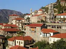
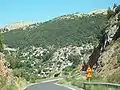
Lagadia (Greek: Λαγκάδια) is a mountain village and a former municipality in Arcadia, Peloponnese, Greece. Since the 2011 local government reform it is part of the municipality Gortynia, of which it is a municipal unit.[2] The municipal unit has an area of 79.475 km2.[3] The seat of the municipality was the village Lagadia. It is considered a traditional settlement and is situated on a mountain slope, at about 1000 m elevation. It is 5 km east of Lefkochori, 10 km north of Dimitsana and 36 km northwest of Tripoli. The Greek National Road 74 (Pyrgos - Olympia - Tripoli) passes through the village.
Lagadia
Λαγκάδια | |
|---|---|
 | |
 Lagadia Location within the regional unit 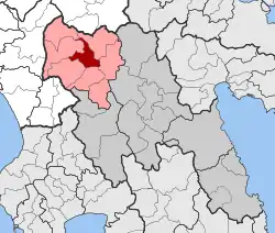 | |
| Coordinates: 37°41′N 22°2′E | |
| Country | Greece |
| Administrative region | Peloponnese |
| Regional unit | Arcadia |
| Municipality | Gortynia |
| • Municipal unit | 79.48 km2 (30.69 sq mi) |
| Elevation | 976 m (3,202 ft) |
| Population (2011)[1] | |
| • Rural | 355 |
| • Municipal unit | 636 |
| • Municipal unit density | 8.0/km2 (21/sq mi) |
| Time zone | UTC+2 (EET) |
| • Summer (DST) | UTC+3 (EEST) |
| Postal code | 220 03 |
| Area code(s) | 27950 |
| Vehicle registration | TP |
The village has a school, a church, a post office, and a square. It is known for its local weaving mill. Lagadia used to be famous in Greece mainly about its builders (called pelekanoi), that made stone-built houses all over the Peloponnese peninsula, and especially in Mani. Kanellos Deligiannis, one of the many heroes of the Greek War of Independence against the Turks in 1821, was born here.
Subdivisions
The municipal unit Langadia is subdivided into the following communities (constituent villages in brackets):
- Lagadia (Lagadia, Agios Athanasios, Agios Nikolaos, Kaloneri, Pteria, Xerovouni)
- Lefkochori (Lefkochori, Fouskari, Touthoa)
Population history
- 1949: 3,333
- 1981: 1,188 (village)
- 1991: 671 (village), 1,993 (municipality)
- 2001: 704 (village), 1,363 (municipality)
- 2011: 355 (village), 504 (community), 636 (municipal unit)
Geography
Climate
Lagadia is located in central Peloponnese and has a Mediterranean climate with hot and dry summers and milder winters.[4]
| Climate data for Lagadia, Greece | |||||||||||||
|---|---|---|---|---|---|---|---|---|---|---|---|---|---|
| Month | Jan | Feb | Mar | Apr | May | Jun | Jul | Aug | Sep | Oct | Nov | Dec | Year |
| Average high °F (°C) | 58.46 (14.70) |
58.82 (14.90) |
62.06 (16.70) |
67.64 (19.80) |
76.1 (24.5) |
84.38 (29.10) |
88.16 (31.20) |
88.16 (31.20) |
83.3 (28.5) |
75.74 (24.30) |
67.1 (19.5) |
60.62 (15.90) |
72.545 (22.53) |
| Average low °F (°C) | 41.36 (5.20) |
41.54 (5.30) |
42.98 (6.10) |
47.3 (8.5) |
53.96 (12.20) |
60.26 (15.70) |
64.22 (17.90) |
64.4 (18.0) |
60.44 (15.80) |
54.86 (12.70) |
48.74 (9.30) |
43.88 (6.60) |
51.995 (11.11) |
| Source: <yr.no >"Weather statistics for Lagadia". Weather statistics for Lagadia, Peloponnese (Greece). yr.no. 2016. Retrieved 12 September 2016. | |||||||||||||
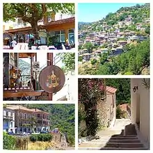
Photo gallery
 View of Lagadia village in Arcadia from roadway.
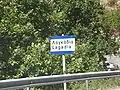 Lagadia village road sign.
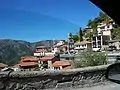 View of Lagadia.
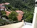 Looking down from roadway at Lagadia village buildings.
 Scene of buildings in Langadia village.
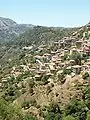 Another view of Lagadia village from afar.
 Chickens in Lagadia village.
 School building in Lagadia village.
 The clock tower of the Taxiarches Church.
References
- "Απογραφή Πληθυσμού - Κατοικιών 2011. ΜΟΝΙΜΟΣ Πληθυσμός" (in Greek). Hellenic Statistical Authority.
- Kallikratis law Greece Ministry of Interior (in Greek)
- "Population & housing census 2001 (incl. area and average elevation)" (PDF) (in Greek). National Statistical Service of Greece. Archived from the original (PDF) on 2015-09-21.
- "Weather". Lonely Planet. Lonely Planet. Retrieved 24 February 2014.