Trikolonoi
Trikolonoi (Greek: Τρικόλωνοι) is a former municipality in Arcadia, Peloponnese, Greece. Since the 2011 local government reform it is part of the municipality Gortynia, of which it is a municipal unit.[2] The municipal unit has an area of 102.031 km2.[3] The municipal unit includes the villages of Stemnitsa (the former municipal seat), Syrna, Pavlia, Palamari and Elliniko. Trikolonoi is located southeast of Dimitsana, west of Tripoli and north of Megalopoli. In 2011 Trikolonoi had a population of 578. The place takes its name from the ancient town of Tricoloni.
Trikolonoi
Τρικόλωνοι | |
|---|---|
 | |
 Trikolonoi Location within the regional unit 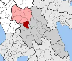 | |
| Coordinates: 37°33′N 22°5′E | |
| Country | Greece |
| Administrative region | Peloponnese |
| Regional unit | Arcadia |
| Municipality | Gortynia |
| • Municipal unit | 102.0 km2 (39.4 sq mi) |
| Population (2011)[1] | |
| • Municipal unit | 578 |
| • Municipal unit density | 5.7/km2 (15/sq mi) |
| Time zone | UTC+2 (EET) |
| • Summer (DST) | UTC+3 (EEST) |
| Postal code | 220 24 |
| Area code(s) | 27950 |
| Vehicle registration | TP |
| Website | www |
Subdivisions
The municipal unit Trikolonoi is subdivided into the following communities (constituent villages in brackets):
Population history
| Year | Population |
|---|---|
| 1991 | 1,255 |
| 2001 | 1,260 |
| 2011 | 578 |
See also
References
- "Απογραφή Πληθυσμού - Κατοικιών 2011. ΜΟΝΙΜΟΣ Πληθυσμός" (in Greek). Hellenic Statistical Authority.
- Kallikratis law Greece Ministry of Interior (in Greek)
- "Population & housing census 2001 (incl. area and average elevation)" (PDF) (in Greek). National Statistical Service of Greece.
External links
Places adjacent to Trikolonoi | ||||||||||
|---|---|---|---|---|---|---|---|---|---|---|
| ||||||||||
This article is issued from Wikipedia. The text is licensed under Creative Commons - Attribution - Sharealike. Additional terms may apply for the media files.