Larapinta Trail
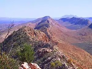
The Larapinta Trail is an extended walking track in the Northern Territory of Australia. Its total length covers 223 kilometres (139 mi) from east to west, with the eastern end at Alice Springs and the western end at Mount Sonder, one of the territory's highest mountains. It follows the West MacDonnell Ranges, sometimes along the ridge line, other times on the plain below, in the West MacDonnell National Park.
| Larapinta Trail | |
|---|---|
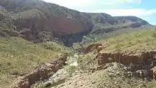
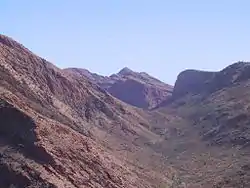 Along the Larapinta trail from a ridge of the West MacDonnell Ranges. | |
| Length | 223 km (139 mi) |
| Location | Northern Territory, Australia |
| Trailheads | Alice Springs, Mount Sonder |
| Use | Hiking |
| Hiking details | |
| Trail difficulty | Medium |
| Season | Winter |
| Months | June to August |
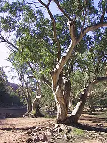
| Sights | Arid mountains, gorges, dry creek beds, waterholes |
| Hazards | Dehydration, Snakes, Hyperthermia, Hypothermia |
| Website | https://nt.gov.au/leisure/parks-reserves/plan-your-visit/bushwalking-hiking/larapinta-trail |
Notable attractions
- Finke River
- Simpsons Gap
- Standley Chasm
- Ellery Creek Bighole
- Serpentine Gorge
- Ochre Pits
- Ormiston Pound
- Redbank Gorge
- Glen Helen Gorge
History
The walk harbours many Aboriginal sacred sites of the Arrernte people, who have permitted tourists to visit the sites. In the 1990s the walk was only half as long, with the section between Mount Sonder and Ellery Big Hole completed at the turn of the millennium. Presently, the Northern Territory government is advertising the walk as Australia's best extended walk, competing with Western Australia's Bibbulmun Track and Tasmania's Overland Track and Western Arthurs track. The original Larapinta trail plan was to end at Mount Zeil on the Western end of the West MacDonnell National Park. The terrain from Mount Sonder to Mount Zeil being hard to access by vehicle for rescue operations, the trail stopped at Mount Sonder.
In September 2006, Belgian adventurer Louis-Philippe Loncke walked without resupply from West of Mount Zeil to Alice Springs[1] walking off track and joining the Larapinta trail at Redbank gorge. On 16 August 2014 Jessica Baker and Meredith Quinlan set a new record arriving at the Alice Springs Telegraph Station in 60 hours and 59 minutes, without crew and only the aid of drop boxes left at 3 locations en route.
Amenities
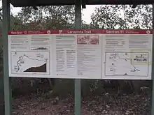
The trail is very well marked with kilometre posts (though often inaccurate) marking both the distance to the next campsite or section as well as the total length of the walk to go. There is a published leaflet that details the requirements and attractions of completing each of the twelve sections and notice boards at the transition of each section. These notice boards also show elevation graphs of the walk and alert walkers to potential dangers.
There is a reasonable amount of water along the track, both naturally found and trucked in. There are only one or two places in which water cannot be obtained throughout the day, with frequent storage tanks. Signage suggests that all water should be treated by boiling it for 5 minutes or adding water treatment tablets. Some sections of the walk have long sections with no water tanks, meaning water must be carried with you.
No fires are allowed along the walk.
There are now APP mapped walk information for the Larapinta. These can provide a useful backup to your maps.
Climate
During the summer months, temperatures along the trail can exceed 45 °C (113 °F) leading to risk of heatstroke and dehydration. Most people walk the trail during winter when the days are cooler.
See also
References
- Alice Springs News, "Hill after Hill", 21 September 2006