Latta, Oklahoma
Latta is an unincorporated community and census-designated place in Pontotoc County, Oklahoma, United States. Its population was 1,172 as of 2016.[2] Oklahoma State Highway 1 passes through the community.
Latta, Oklahoma | |
|---|---|
 Latta, Oklahoma  Latta, Oklahoma | |
| Coordinates: 34°44′49″N 96°42′21″W | |
| Country | United States |
| State | Oklahoma |
| County | Pontotoc |
| Area | |
| • Total | 2.520 sq mi (6.53 km2) |
| • Land | 2.520 sq mi (6.53 km2) |
| • Water | 0 sq mi (0 km2) |
| Elevation | 1,027 ft (313 m) |
| Population | |
| • Total | 1,172 |
| • Density | 470/sq mi (180/km2) |
| Time zone | UTC-6 (Central (CST)) |
| • Summer (DST) | UTC-5 (CDT) |
| Area code(s) | 580 |
| GNIS feature ID | 1094521[3] |
Geography
According to the U.S. Census Bureau, the community has an area of 2.520 square miles (6.53 km2), all land.[1]
References
- "2016 U.S. Gazetteer Files - Places: Oklahoma". U.S. Census Bureau. Retrieved September 11, 2018.
- "Latta CDP, Oklahoma 2016 ACS 5-Year Population Estimate". American FactFinder. U.S. Census Bureau. Archived from the original on February 13, 2020. Retrieved September 11, 2018.
- "Latta". Geographic Names Information System. United States Geological Survey.
Municipalities and communities of Pontotoc County, Oklahoma, United States | ||
|---|---|---|
| City | 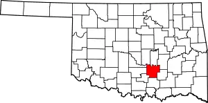 Pontotoc County map | |
| Towns | ||
| CDP | ||
| Other unincorporated communities |
| |
| Indian reservations | ||
| Footnotes | ‡This populated place also has portions in an adjacent county or counties | |
| ||
This article is issued from Wikipedia. The text is licensed under Creative Commons - Attribution - Sharealike. Additional terms may apply for the media files.