Laurier, Washington
Laurier is a census-designated place in Ferry County, Washington that neighbors the Canada–United States border.[3] The nearest school district is Orient School District.[4] According to the 2010 census, Laurier had a population of one.[5]
Laurier, Washington | |
|---|---|
 Laurier  Laurier | |
| Coordinates: 48°59′56″N 118°13′27″W | |
| Country | United States |
| State | Washington |
| County | Ferry |
| Area | |
| • Total | 0.06 sq mi (0.16 km2) |
| • Land | 0.06 sq mi (0.16 km2) |
| • Water | 0 sq mi (0 km2) |
| Elevation | 1,654 ft (504 m) |
| Population (2010) | |
| • Total | 1 |
| • Density | 16/sq mi (6.3/km2) |
| Time zone | UTC-8 (Pacific (PST)) |
| • Summer (DST) | UTC-7 (PDT) |
| ZIP code | 99146 |
| Area code(s) | 509 |
| FIPS code | 53-38705[1] |
| GNIS feature ID | 1521941[2] |
Laurier was named for Sir Wilfrid Laurier, prime minister of Canada from 1896 to 1911.[6] The federal U.S. General Services Administration lists three buildings in Laurier – a border station and two border station residences – all built in 1936.[7] U.S. Route 395 runs through the community north to the Canada–US border, where it becomes British Columbia Highway 395. The Avey Field State Airport is in Laurier and its runway crosses the border into British Columbia.
Climate
This climatic region is typified by large seasonal temperature differences, with warm to hot (and often humid) summers and cold (sometimes severely cold) winters. According to the Köppen Climate Classification system, Laurier has a humid continental climate, abbreviated "Dfb" on climate maps.[8]
| Climate data for Laurier | |||||||||||||
|---|---|---|---|---|---|---|---|---|---|---|---|---|---|
| Month | Jan | Feb | Mar | Apr | May | Jun | Jul | Aug | Sep | Oct | Nov | Dec | Year |
| Record high °F (°C) | 57 (14) |
58 (14) |
73 (23) |
92 (33) |
102 (39) |
103 (39) |
109 (43) |
106 (41) |
105 (41) |
85 (29) |
61 (16) |
56 (13) |
109 (43) |
| Average high °F (°C) | 29.8 (−1.2) |
37.9 (3.3) |
49.3 (9.6) |
62.2 (16.8) |
71.7 (22.1) |
78.1 (25.6) |
87.3 (30.7) |
86.2 (30.1) |
74.8 (23.8) |
58.3 (14.6) |
40.5 (4.7) |
31.8 (−0.1) |
59 (15) |
| Average low °F (°C) | 15.1 (−9.4) |
18.9 (−7.3) |
25.2 (−3.8) |
32.1 (0.1) |
39.8 (4.3) |
46.5 (8.1) |
50 (10) |
48.8 (9.3) |
41.3 (5.2) |
33.4 (0.8) |
26.6 (−3.0) |
19.4 (−7.0) |
33.1 (0.6) |
| Record low °F (°C) | −32 (−36) |
−30 (−34) |
−13 (−25) |
11 (−12) |
16 (−9) |
28 (−2) |
30 (−1) |
31 (−1) |
18 (−8) |
6 (−14) |
−14 (−26) |
−32 (−36) |
−32 (−36) |
| Average precipitation inches (mm) | 2.08 (53) |
1.39 (35) |
1.27 (32) |
1.34 (34) |
1.8 (46) |
2.05 (52) |
1.07 (27) |
1.09 (28) |
1.23 (31) |
1.57 (40) |
2.1 (53) |
2.21 (56) |
19.19 (487) |
| Average snowfall inches (cm) | 18.4 (47) |
8.5 (22) |
3.1 (7.9) |
0.1 (0.25) |
0 (0) |
0 (0) |
0 (0) |
0 (0) |
0 (0) |
0.7 (1.8) |
5.6 (14) |
16 (41) |
52.5 (133) |
| Average precipitation days | 14 | 10 | 10 | 9 | 11 | 11 | 6 | 6 | 7 | 10 | 14 | 14 | 122 |
| Source: [9] | |||||||||||||
References
- "U.S. Census website". United States Census Bureau. Retrieved 2011-05-14.
- U.S. Geological Survey Geographic Names Information System: Laurier, Washington
- Laurier, Washington WA Community Profile / Ferry County, WA Data
- Orient School District - Laurier Washington WA - AmericanTowns.com
- "Geographic Identifiers: 2010 Demographic Profile Data (G001): Laurier CDP, Washington". U.S. Census Bureau, American Factfinder. Retrieved October 24, 2016.
- Tacoma Public Library, Washington Place Names Database Archived 2012-07-23 at Archive.today: "Laurier"
- "Find a Building". U.S. General Services Administration. Archived from the original on March 4, 2016. Retrieved November 30, 2012. The GSA building numbers are WA0601LB, WA0602LB, and WA0603LB.
- Climate Summary for Laurier, Washington
- "LAURIER, WASHINGTON (454549)". Western Regional Climate Center. Retrieved November 16, 2015.
External links
Municipalities and communities of Ferry County, Washington, United States | ||
|---|---|---|
| City | 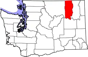 Map of Washington highlighting Ferry County | |
| CDPs | ||
| Other unincorporated communities | ||
| Indian reservation | ||
| Ghost town | ||
| Footnotes | ‡This populated place also has portions in an adjacent county or counties | |
| ||