Boyds, Washington
Boyds is an unincorporated community and census-designated place (CDP) in Ferry County, Washington, United States. Boyds is located along U.S. Route 395 at the north end of the Lake Roosevelt National Recreation Area on the west side of the Kettle River, which serves as a boundary with Stevens County. The community of Barstow is 4 miles (6 km) to the north, and the city of Kettle Falls is 10 miles (16 km) to the south on US 395. Boyds was formerly assigned the ZIP code 99107 and had a 2010 census population of 34.[2]
Boyds, Washington | |
|---|---|
 Boyds  Boyds | |
| Coordinates: 48°42′50″N 118°07′58″W | |
| Country | United States |
| State | Washington |
| County | Ferry |
| Area | |
| • Total | 0.19 sq mi (0.50 km2) |
| • Land | 0.19 sq mi (0.50 km2) |
| • Water | 0.0 sq mi (0.0 km2) |
| Elevation | 1,352 ft (412 m) |
| Population (2010) | |
| • Total | 34 |
| • Density | 175/sq mi (67.5/km2) |
| Time zone | UTC-8 (Pacific (PST)) |
| • Summer (DST) | UTC-7 (PDT) |
| Area code(s) | 509 |
| GNIS feature ID | 1516912[1] |
| FIPS code | 53-07485 |
References
- U.S. Geological Survey Geographic Names Information System: Boyds, Washington
- "Geographic Identifiers: 2010 Demographic Profile Data (G001): Boyds CDP, Washington". U.S. Census Bureau, American Factfinder. Retrieved October 21, 2016.
Municipalities and communities of Ferry County, Washington, United States | ||
|---|---|---|
| City | 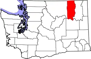 Map of Washington highlighting Ferry County | |
| CDPs | ||
| Other unincorporated communities | ||
| Indian reservation | ||
| Ghost town | ||
| Footnotes | ‡This populated place also has portions in an adjacent county or counties | |
| ||
This article is issued from Wikipedia. The text is licensed under Creative Commons - Attribution - Sharealike. Additional terms may apply for the media files.