Lee Vining, California
Lee Vining (formerly, Leevining, Poverty Flat, and Lakeview)[3] is a census-designated place[4] in Mono County, California, United States.[2] It is located 21 miles (34 km) south-southeast of Bridgeport,[3] at an elevation of 6781 feet (2067 m).[2] Lee Vining is located on the southwest shore of Mono Lake. The population was 222 as of the 2010 census, down from 250 reported as of 2000 by Mono County.[5] At the previous census (1990) the town population was 398, and at the census before that (1980) it was 315.
Lee Vining | |
|---|---|
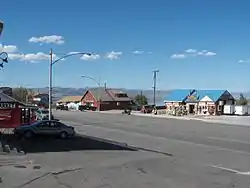 Lee Vining lies at the base of the Sierra Nevada, on the shore of Mono Lake. | |
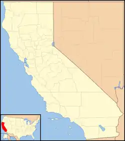
 Location of Lee Vining in Mono County, California. | |
 Lee Vining Location in California | |
| Coordinates: 37°57′27″N 119°07′19″W | |
| Country | United States |
| State | California |
| County | Mono |
| Area | |
| • Total | 5.220 sq mi (13.521 km2) |
| • Land | 5.218 sq mi (13.514 km2) |
| • Water | 0.002 sq mi (0.006 km2) 0.05% |
| Elevation | 6,781 ft (2,067 m) |
| Population (2010) | |
| • Total | 222 |
| • Density | 43/sq mi (16/km2) |
| Time zone | UTC-8 (Pacific (PST)) |
| • Summer (DST) | UTC-7 (PDT) |
| ZIP Code | 93541 |
| Area codes | 442/760 |
| GNIS feature IDs | 262401; 2583054 |
| U.S. Geological Survey Geographic Names Information System: Lee Vining, California; U.S. Geological Survey Geographic Names Information System: Lee Vining, California | |
Economy
The economy of Lee Vining relies largely on tourism, since it is the closest town to the east entrance of Yosemite National Park, and is near other tourist destinations such as Mono Lake, the ghost town of Bodie, popular trout fishing destinations, and June Mountain and Mammoth Mountain ski areas and the June Lake recreational area. Although off-season tourism has increased in recent years, most tourists visit in the summer months because State Route 120 through Yosemite is often closed otherwise due to heavy snowfall in the winter. Lee Vining has a year-round Information Center for visitors.
Geography
According to the United States Census Bureau, the CDP covers an area of 5.2 square miles (13.5 km2), 99.95% of it land, and 0.05% of it water.
Climate
Lee Vining, on the boundary between the Sierra Nevada and Great Basin ecoregions, has a transitional climate warmer and drier than the mountains to the west but cooler and much snowier than the vast desert to the east. Despite only getting 14 inches of water-equivalent precipitation annually, the town averages nearly six feet of snow, sometimes falling as late as April or even May. Precipitation is highest in the winter months of December through March, but some can be expected to fall every month of the year and the town does not typically experience the four to six month dry spells of more coastal parts of California.
| Climate data for Lee Vining, California | |||||||||||||
|---|---|---|---|---|---|---|---|---|---|---|---|---|---|
| Month | Jan | Feb | Mar | Apr | May | Jun | Jul | Aug | Sep | Oct | Nov | Dec | Year |
| Record high °F (°C) | 64 (18) |
66 (19) |
85 (29) |
79 (26) |
89 (32) |
90 (32) |
96 (36) |
93 (34) |
89 (32) |
82 (28) |
75 (24) |
65 (18) |
96 (36) |
| Average high °F (°C) | 40.2 (4.6) |
42.6 (5.9) |
51.8 (11.0) |
58.0 (14.4) |
66.8 (19.3) |
76.2 (24.6) |
84.4 (29.1) |
82.9 (28.3) |
76.0 (24.4) |
65.4 (18.6) |
52.6 (11.4) |
41.9 (5.5) |
61.6 (16.4) |
| Daily mean °F (°C) | 29.9 (−1.2) |
32.2 (0.1) |
39.7 (4.3) |
45.1 (7.3) |
53.3 (11.8) |
61.5 (16.4) |
69.0 (20.6) |
67.4 (19.7) |
60.7 (15.9) |
50.7 (10.4) |
40.0 (4.4) |
31.4 (−0.3) |
48.4 (9.1) |
| Average low °F (°C) | 19.6 (−6.9) |
21.8 (−5.7) |
27.7 (−2.4) |
32.3 (0.2) |
39.7 (4.3) |
46.8 (8.2) |
53.6 (12.0) |
52.0 (11.1) |
45.5 (7.5) |
36.1 (2.3) |
27.4 (−2.6) |
20.9 (−6.2) |
35.3 (1.8) |
| Record low °F (°C) | −3 (−19) |
−8 (−22) |
3 (−16) |
12 (−11) |
20 (−7) |
27 (−3) |
36 (2) |
38 (3) |
28 (−2) |
18 (−8) |
5 (−15) |
−9 (−23) |
−9 (−23) |
| Average precipitation inches (mm) | 2.82 (72) |
2.48 (63) |
1.65 (42) |
0.57 (14) |
0.55 (14) |
0.31 (7.9) |
0.46 (12) |
0.42 (11) |
0.32 (8.1) |
0.84 (21) |
1.35 (34) |
2.35 (60) |
14.14 (359) |
| Average snowfall inches (cm) | 20.3 (52) |
16.9 (43) |
10.7 (27) |
2.8 (7.1) |
0.9 (2.3) |
0.2 (0.51) |
0 (0) |
0 (0) |
0 (0) |
1.6 (4.1) |
3.8 (9.7) |
13.4 (34) |
70.7 (180) |
| Average precipitation days | 7 | 7 | 5 | 3 | 3 | 2 | 3 | 2 | 2 | 3 | 4 | 5 | 47 |
| Source: Western Regional Climate Center[6] | |||||||||||||
History
The town was named after Leroy Vining, who founded the town in 1852 as a mining camp. In 1926, the town was laid out by Chris Mattly and named "Lakeview",[3] but when a post office was sought in 1928, it was learned that another town, Lakeview, California already had the name. The name of Lee Vining was chosen in 1953.[3] The place was also called Poverty Flat for its unfavorable conditions for agriculture.[3]
Sights
The town is the site of the Upside-Down House, a distinctive local landmark built by silent film actress Nellie Bly O'Bryan.[7] Also located in the town is the Whoa Nellie Deli, which was once described by the San Francisco Chronicle as "a misplaced Fellini set carved into the edge of the Mono Basin, dust devils skipping around in the distance like extras on the floor of Owens Valley."[8]
The town is home to the Mono Cone burger and ice-cream store, open in the spring and summer. Gus Hess Park commemorates an early miner in Lee Vining.
Lee Vining is situated near the foot of Lee Vining Canyon. State Route 120 runs from town, through the canyon, up to Tioga Pass. Lee Vining Canyon is one of only two ice climbing venues in California. U.S. Route 395 also runs through the town, connecting to Los Angeles 390 miles (630 km) to the South, and Reno, Nevada 135 miles (217 km) to the North.
The Lee Vining Airport lies near the town. The ZIP Code is 93541. The community is inside area codes 442 and 760.
Demographics
The 2010 United States Census[9] reported that Lee Vining had a population of 222. The population density was 42.5 people per square mile (16.4/km2). The racial makeup of Lee Vining was 126 (56.8%) White, 0 (0.0%) African American, 25 (11.3%) Native American, 0 (0.0%) Asian/Pacific Islander, 64 (28.8%) from other races, and 7 (3.2%) from two or more races. Hispanic or Latino of any race were 96 persons (43.2%).
The Census reported that 213 people (95.9% of the population) lived in households, 9 (4.1%) lived in non-institutionalized group quarters, and 0 (0%) were institutionalized.
There were 85 households, out of which 31 (36.5%) had children under the age of 18 living in them, 44 (51.8%) were opposite-sex married couples living together, 4 (4.7%) had a female householder with no husband present, 5 (5.9%) had a male householder with no wife present. There were 5 (5.9%) unmarried opposite-sex partnerships, and 1 (1.2%) same-sex married couples or partnerships. 28 households (32.9%) were made up of individuals, and 6 (7.1%) had someone living alone who was 65 years of age or older. The average household size was 2.51. There were 53 families (62.4% of all households); the average family size was 3.25.
The population was spread out, with 56 people (25.2%) under the age of 18, 26 people (11.7%) aged 18 to 24, 71 people (32.0%) aged 25 to 44, 52 people (23.4%) aged 45 to 64, and 17 people (7.7%) who were 65 years of age or older. The median age was 30.4 years. For every 100 females, there were 107.5 males. For every 100 females age 18 and over, there were 102.4 males.
There were 112 housing units at an average density of 21.5 per square mile (8.3/km2), of which 43 (50.6%) were owner-occupied, and 42 (49.4%) were occupied by renters. The homeowner vacancy rate was 2.3%; the rental vacancy rate was 10.6%. 108 people (48.6% of the population) lived in owner-occupied housing units and 105 people (47.3%) lived in rental housing units.
Government
In the California State Legislature, Lee Vining is in the 8th Senate District, represented by Republican Andreas Borgeas, and in the 5th Assembly District, represented by Republican Frank Bigelow.[10]
In the United States House of Representatives, Lee Vining is in California's 8th congressional district, represented by Republican Jay Obernolte.[11]
Education
Lee Vining is in the Eastern Sierra Unified School District.[12] An elementary school and a high school (Lee Vining High School) are located in Lee Vining.[12] Lee Vining also has a public library.[12]
References
- "2010 Census U.S. Gazetteer Files – Places – California". United States Census Bureau.
- "Lee Vining". Geographic Names Information System. United States Geological Survey. Retrieved April 8, 2015.
- Durham, David L. (1998). California's Geographic Names: A Gazetteer of Historic and Modern Names of the State. Clovis, Calif.: Word Dancer Press. p. 1178. ISBN 1-884995-14-4.
- U.S. Geological Survey Geographic Names Information System: Lee Vining, California
- Mono County populations Archived April 30, 2009, at the Wayback Machine
- "Lee Vining, California". Western Regional Climate Center. Desert Research Institute. Retrieved May 20, 2020.
- McKinley, Jesse (October 13, 2008). "Promoting Offbeat History Between the Drinks". The New York Times. Retrieved October 10, 2017.
- Hall, Carl T. (August 17, 2005). "Fill 'er up means more than gas at quirky mountain Mobil". San Francisco Chronicle.
- "2010 Census Interactive Population Search: CA – Lee Vining CDP". U.S. Census Bureau. Archived from the original on July 15, 2014. Retrieved July 12, 2014.
- "Statewide Database". Regents of the University of California. Archived from the original on February 1, 2015. Retrieved April 8, 2015.
- "California's 8th Congressional District - Representatives & District Map". Civic Impulse, LLC. Retrieved October 1, 2014.
- Mono County Office of Education
External links
- U.S. Geological Survey Geographic Names Information System: Lee Vining
- Lee Vining Chamber of Commerce
- Mono Lake Website
Municipalities and communities of Mono County, California, United States | ||
|---|---|---|
| Town | 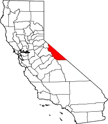 Mono County map | |
| CDPs | ||
| Unincorporated communities | ||
| Indian reservations | ||
| Former settlements | ||
| ||