Swall Meadows, California
Swall Meadows is a census-designated place[2] in southern Mono County, California. The community is residential, including second homes and a volunteer fire department, but no commercial development. Geographically, it sits partway up the Sherwin Grade below the Wheeler Crest of the eastern Sierra Nevada, at an elevation range of approximately 6,000 to 7,000 feet (1,800 to 2,100 m). It is in pinon-juniper/subalpine zone habitat, with views south along the Sierra Crest of Mt. Tom, and east across Owens Valley to the White Mountains toward Nevada (image, below). It is accessed from "old 395", or Lower Rock Creek Road. Swall Meadows is approximately 20 miles (32 km) north of Bishop and 25 miles (40 km) south of Mammoth Lakes (by highway distance). It is also well known in the area as an important deer migration route for the Round Valley mule deer population, which cherish the grazing in the meadow and apple falls from the old orchard trees. The ZIP Code is 93514.[3] The community is inside area code 760. The population was 220 as of the 2010 census.
Swall Meadows | |
|---|---|
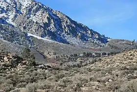 Top end of Swall Meadows (center), below the Wheeler Crest | |
 Street map | |
 Swall Meadows Location in California | |
| Coordinates: 37°30′22″N 118°38′34″W | |
| Country | |
| State | |
| County | Mono |
| Area | |
| • Total | 4.462 sq mi (11.556 km2) |
| • Land | 4.462 sq mi (11.556 km2) |
| • Water | 0 sq mi (0 km2) 0% |
| Elevation | 6,558 ft (1,999 m) |
| Population (2010) | |
| • Total | 220 |
| • Density | 49/sq mi (19/km2) |
| Time zone | UTC-8 (Pacific (PST)) |
| • Summer (DST) | UTC-7 (PDT) |
| ZIP Code | 93514 |
| Area codes | 442/760 |
| FIPS code | 06-77430 |
| GNIS feature IDs | 2583158, 2583158 |
| U.S. Geological Survey Geographic Names Information System: Swall Meadows, California | |
Geography
According to the United States Census Bureau, the CDP covers an area of 4.5 square miles (11.6 km2), all of it land. At the high, northwestern end is the old Sky Meadows Ranch, then houses and firehouse near the meadow, and at the southeast end a development known as Pinyon Ranch.
In addition to the predominant pinyon-juniper-sagebrush habitat, there are permanent and seasonal streams and the eponymous meadow with wetter-habitat vegetation such as Jeffrey pines, willows, stream and bog orchids, and the remnant trees of the old commercial apple orchard. In 2011 the Eastern Sierra Land Trust secured a conservation easement to protect 104 acres of the Swall Meadows meadow area (location of the historic homesite), for the continued benefit of the migrating mule deer. A number of other conservation easements have been completed in Swall Meadows since the ESLT organization was founded in 2001.
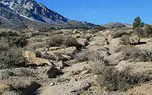
Between Paradise and Swall Meadows the old wagon road can be seen (image, left) that climbed about 3,000 ft (910 m) up the Sherwin Grade from Owens Valley toward Crowley Lake.
Demographics
The 2010 United States Census[4] reported that Swall Meadows had a population of 220. The population density was 49.3 people per square mile (19.0/km2). The racial makeup of Swall Meadows was 201 (91.4%) White, 0 (0.0%) African American, 3 (1.4%) Native American, 5 (2.3%) Asian, 0 (0.0%) Pacific Islander, 2 (0.9%) from other races, and 9 (4.1%) from two or more races. Hispanic or Latino of any race were 6 persons (2.7%).
The Census reported that 220 people (100% of the population) lived in households, 0 (0%) lived in non-institutionalized group quarters, and 0 (0%) were institutionalized.
There were 98 households, out of which 25 (25.5%) had children under the age of 18 living in them, 68 (69.4%) were opposite-sex married couples living together, 4 (4.1%) had a female householder with no husband present, 3 (3.1%) had a male householder with no wife present. There were 2 (2.0%) unmarried opposite-sex partnerships, and 0 (0%) same-sex married couples or partnerships. 21 households (21.4%) were made up of individuals, and 10 (10.2%) had someone living alone who was 65 years of age or older. The average household size was 2.24. There were 75 families (76.5% of all households); the average family size was 2.60.
The population was spread out, with 36 people (16.4%) under the age of 18, 6 people (2.7%) aged 18 to 24, 37 people (16.8%) aged 25 to 44, 99 people (45.0%) aged 45 to 64, and 42 people (19.1%) who were 65 years of age or older. The median age was 53.8 years. For every 100 females, there were 89.7 males. For every 100 females age 18 and over, there were 100.0 males.

There were 128 housing units at an average density of 28.7 per square mile (11.1/km2), of which 90 (91.8%) were owner-occupied, and 8 (8.2%) were occupied by renters. The homeowner vacancy rate was 0%; the rental vacancy rate was 0%. 201 people (91.4% of the population) lived in owner-occupied housing units and 19 people (8.6%) lived in rental housing units.
Government
In the California State Legislature, Swall Meadows is in the 8th Senate District, represented by Republican Andreas Borgeas, and in the 5th Assembly District, represented by Republican Frank Bigelow.[5]
In the United States House of Representatives, Swall Meadows is in California's 8th congressional district, represented by Republican Jay Obernolte.[6]
Round Fire
On February 6, 2015, Swall Meadows and the neighboring community of Paradise were ravaged by the Round Fire, which burned 7,000 acres (28 km2).[7] The fire destroyed 40 homes: 39 homes in Swall Meadows and 1 home in Paradise.[8]
See also
References
- "2010 Census U.S. Gazetteer Files – Places – California". United States Census Bureau.
- "Swall Meadows Census Designated Place". Geographic Names Information System. United States Geological Survey. Retrieved January 4, 2015.
- "USPS.com – ZIP Code Lookup". usps.com. Retrieved 21 September 2015.
- "2010 Census Interactive Population Search: CA – Swall Meadows CDP". U.S. Census Bureau. Archived from the original on July 15, 2014. Retrieved July 12, 2014.
- "Statewide Database". UC Regents. Archived from the original on February 1, 2015. Retrieved December 30, 2014.
- "California's 8th Congressional District - Representatives & District Map". Civic Impulse, LLC. Retrieved October 1, 2014.
- "Firefighters Work to Contain Destructive California Wildfire Near Swall Meadows". Huffington Post. 2015-02-08.
- "Wildfire destroys 40 homes, burns 11 square miles of timber in California near Nevada line". US News and World Report. 2015-02-08.
External links
| Wikimedia Commons has media related to Swall Meadows, California. |
Municipalities and communities of Mono County, California, United States | ||
|---|---|---|
| Town |  Mono County map | |
| CDPs | ||
| Unincorporated communities | ||
| Indian reservations | ||
| Former settlements | ||
| ||