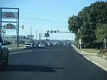
Lehigh Street
Lehigh Street is a major road that connects Emmaus, Pennsylvania in the west to Allentown, Pennsylvania in the east, in the Lehigh Valley region of Pennsylvania, in the United States. The road is one of six roads that enter and depart Allentown, Pennsylvania, the third largest city in the state.
| Location | Allentown, Pennsylvania |
|---|---|
| South end | State Avenue in Emmaus |
| Major junctions | |
| East end |
Lehigh Street is one of several major Allentown-area exits off Interstate 78, which runs from Interstate 81 in Lebanon County in the west to the Holland Tunnel and New York City in the east.
Lehigh Street also serves as a major commercial center for the Lehigh Valley. It is particularly well known for its "auto mile", which includes approximately a dozen new and used automobile dealerships. As the road enters Allentown from the west, it also runs by Queen City Airport, an Allentown airport used mostly by small, privately owned aircraft. The South Mall, in Salisbury Township, is located on Lehigh Street.
The Emmaus side of Lehigh Street is the location of Shangy's, a beer distributor with the largest selection of domestic and global beers in the nation (over 3,000 in all). Rodale Press, a leading global publisher of health-related books and magazines, also is located off Lehigh Street, on the Emmaus side of the road.
Route description

Lehigh Street is a continuation of State Avenue near South Mall, in the northern sections of Emmaus. Upon crossing the Allentown-Emmaus boundary, it widens to a four-lane road with a center left-turn lane. From there, Lehigh runs northward traversing one of the busiest commercial districts in the city.
North of 29th Street SW, Lehigh Street interchanges the Interstate 78/Pennsylvania Route 309 overlap. North of the underpass, Lehigh is designated east of Queen City Airport.
The street runs away of the airport, while progressing northward. At the intersection with Jefferson Street, Lehigh Street narrows to two-lanes and turns slightly to run on a northeast course. North of 12th Street, the street does not have the center left-turn lane.
A couple of blocks from South 12th Street, Lehigh Street intersects several Allentown-area roads and passes south of the abandoned Bicentennial Park. At Wyoming Street, Lehigh turns east and widens to three-lanes (two southbound and one northbound). Briefly west of S. 8th Street, Lehigh Street eastbound continues as Saint John Street up to S. 6th Street (PA 145 south).
Lehigh Street westbound splits at the intersection with PA 145 (South 6th Street/Auburn Street), four blocks from downtown Allentown. The one-way roadway merges with Saint John Street which becomes Lehigh Street eastbound. North of this, PA 145 follows two-way Lehigh Street north, intersecting Martin Luther King, Jr. Drive. Lehigh Street ends at the intersection with Union Street in downtown Allentown, where PA 145 splits into a one-way pair along that street.[1]
History
In 1941, from Cedar Crest Boulevard in Emmaus to S. 6th Street and Auburn Street (today PA 145) in Allentown, Lehigh Street was designated as Pennsylvania Route 29.[2] By 1960, the designation was removed.[3]
Major intersections
The entire route is in Lehigh County.
| Location | mi | km | Destinations | Notes | |
|---|---|---|---|---|---|
| Emmaus | State Avenue | Southern terminus | |||
| Allentown | Exit 57 (I-78/PA 309). | ||||
| South end of PA 145 overlap | |||||
| Northern terminus | |||||
| 1.000 mi = 1.609 km; 1.000 km = 0.621 mi | |||||
References
- Tourism and Transportation Map (Map). Cartography by Geographic Information Division Bureau of Planning and Research. PennDOT. 2007. § W8.
|access-date=requires|url=(help) - 1941 Lehigh County Map (PDF) (Map). Pennsylvania Department of Highways. Retrieved 2007-07-31.
- 1960 Lehigh County Map (PDF) (Map). Pennsylvania Department of Highways. Retrieved 2007-07-31.
