Lehigh County, Pennsylvania
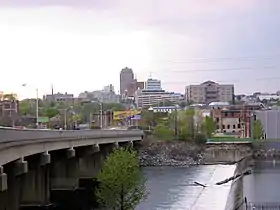
Lehigh County (Pennsylvania German: Lechaa Kaundi) is a county located in the Lehigh Valley region of the U.S. state of Pennsylvania. As of the 2010 census, the population was 349,497.[1] Its county seat is Allentown, the state's third-largest city behind Philadelphia and Pittsburgh.[2] The county, which was first settled around 1730, was formed in 1812 with the division of Northampton County into two counties. It is named after the Lehigh River, whose name is derived from the Delaware Indian term Lechauweki or Lechauwekink, meaning "where there are forks".[3]
Lehigh County | |
|---|---|
 | |
 Seal | |
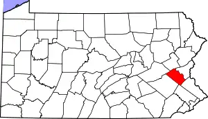 Location within the U.S. state of Pennsylvania | |
 Pennsylvania's location within the U.S. | |
| Coordinates: 40°37′N 75°35′W | |
| Country | |
| State | |
| Founded | March 6, 1812 |
| Named for | Lehigh River |
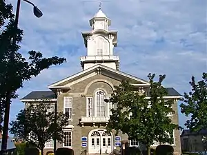
| Seat | Allentown |
| Largest city | Allentown |
| Area | |
| • Total | 348 sq mi (900 km2) |
| • Land | 345 sq mi (890 km2) |
| • Water | 3.1 sq mi (8 km2) 0.9%% |
| Population | |
| • Estimate (2019) | 369,318 |
| • Density | 1,046/sq mi (404/km2) |
| Time zone | UTC−5 (Eastern) |
| • Summer (DST) | UTC−4 (EDT) |
| Congressional district | 7th |
| Website | www |
Lehigh County is part of the Allentown-Bethlehem-Easton, PA-NJ metropolitan area, but also borders the Delaware Valley and is a part of the Philadelphia media market. It is one of the fastest-growing counties in Pennsylvania.[4]
Geography
According to the U.S. Census Bureau, the county has a total area of 348 square miles (900 km2), of which 345 square miles (890 km2) is land and 3.1 square miles (8.0 km2) (0.9%) is water.[5]
Topography
The Lehigh Valley, which includes all of Lehigh and Northampton counties, is bounded on the north by Blue Mountain, a ridge of the Appalachian mountain range with an altitude of 1,300 to 1,604 feet (396 to 489 m), and on the south by South Mountain, a ridge of 700 to 1,100 feet (210 to 340 m) that cuts through the southern portions of the two counties. The highest point in Lehigh County is Bake Oven Knob, a mass of Tuscarora conglomeratic rocks that rise about 100 feet (30 m) above the main ridge of the Blue Mountain in northwestern Heidelberg Township.[6]
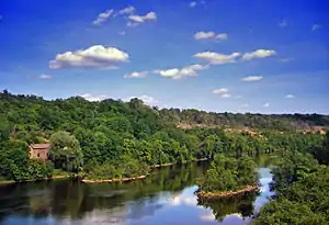
Lehigh County is in the Delaware River watershed. While most of the county is drained by the Lehigh River and its tributaries, the Schuylkill River also drains regions in the south of the county via the Perkiomen Creek and the northwest via the Maiden Creek.
Adjacent counties
- Berks County (west)
- Bucks County (southeast)
- Carbon County (north)
- Montgomery County (south)
- Northampton County (northeast)
- Schuylkill County (northwest)
Climate
The county's climate is considered to fall in the humid continental climate zone. The variety is hot-summer (Dfa) except in higher areas where it is warm-summer (Dfb). Summers are typically hot and muggy, fall and spring are generally mild, and winter is cold. Precipitation is almost uniformly distributed throughout the year.
For the city of Allentown, January lows average −6 °C (21 °F) and highs average 1.3 °C (34.3 °F). The lowest officially recorded temperature was −26.7 °C (−16.1 °F) in 1912. July lows average 17.6 °C (63.7 °F) and highs average 29.2 °C (84.6 °F), with an average relative humidity (morning) of 82%. The highest temperature on record was 40.6 °C (105.1 °F) in 1966. Early fall and mid winter are generally driest, with October being the driest month with only 74.7 mm of average precipitation.[7]
The hardiness zone is mainly 6b with some 6a in higher areas.[8]
Snowfall is variable, with some winters bringing light snow and others bringing numerous significant snowstorms. Average snowfall is 82.3 centimetres (32.4 in) per year,[9] with the months of January and February receiving the highest at just over 22.86 centimetres (9.00 in) each. Rainfall is generally spread throughout the year, with eight to twelve wet days per month,[10] at an average annual rate of 110.54 centimetres (43.52 in).[11]
| Climate data for Allentown, Pennsylvania (Lehigh Valley Int'l), 1981–2010 normals,[lower-alpha 1] extremes 1922–present[lower-alpha 2] | |||||||||||||
|---|---|---|---|---|---|---|---|---|---|---|---|---|---|
| Month | Jan | Feb | Mar | Apr | May | Jun | Jul | Aug | Sep | Oct | Nov | Dec | Year |
| Record high °F (°C) | 72 (22) |
81 (27) |
87 (31) |
93 (34) |
97 (36) |
100 (38) |
105 (41) |
100 (38) |
99 (37) |
93 (34) |
81 (27) |
72 (22) |
105 (41) |
| Mean maximum °F (°C) | 57.9 (14.4) |
59.6 (15.3) |
71.6 (22.0) |
82.5 (28.1) |
88.2 (31.2) |
91.9 (33.3) |
94.2 (34.6) |
92.5 (33.6) |
88.0 (31.1) |
79.0 (26.1) |
70.6 (21.4) |
59.7 (15.4) |
95.4 (35.2) |
| Average high °F (°C) | 36.0 (2.2) |
39.8 (4.3) |
49.4 (9.7) |
61.3 (16.3) |
71.5 (21.9) |
80.1 (26.7) |
84.2 (29.0) |
82.4 (28.0) |
74.9 (23.8) |
63.6 (17.6) |
52.5 (11.4) |
40.5 (4.7) |
61.4 (16.3) |
| Average low °F (°C) | 19.5 (−6.9) |
21.7 (−5.7) |
28.8 (−1.8) |
38.5 (3.6) |
48.3 (9.1) |
58.1 (14.5) |
62.7 (17.1) |
60.9 (16.1) |
52.9 (11.6) |
41.3 (5.2) |
32.9 (0.5) |
24.0 (−4.4) |
40.9 (4.9) |
| Mean minimum °F (°C) | 3.0 (−16.1) |
5.7 (−14.6) |
13.1 (−10.5) |
26.0 (−3.3) |
35.5 (1.9) |
46.3 (7.9) |
52.6 (11.4) |
49.8 (9.9) |
39.2 (4.0) |
28.8 (−1.8) |
19.9 (−6.7) |
9.1 (−12.7) |
0.2 (−17.7) |
| Record low °F (°C) | −15 (−26) |
−12 (−24) |
−5 (−21) |
12 (−11) |
28 (−2) |
39 (4) |
46 (8) |
41 (5) |
30 (−1) |
21 (−6) |
3 (−16) |
−8 (−22) |
−15 (−26) |
| Average precipitation inches (mm) | 3.03 (77) |
2.70 (69) |
3.39 (86) |
3.56 (90) |
4.14 (105) |
4.31 (109) |
4.95 (126) |
3.69 (94) |
4.62 (117) |
3.88 (99) |
3.50 (89) |
3.58 (91) |
45.35 (1,152) |
| Average snowfall inches (cm) | 10.0 (25) |
11.1 (28) |
4.9 (12) |
1.0 (2.5) |
0 (0) |
0 (0) |
0 (0) |
0 (0) |
0 (0) |
0 (0) |
0.7 (1.8) |
5.2 (13) |
32.9 (84) |
| Average precipitation days (≥ 0.01 in) | 11.1 | 9.8 | 11.0 | 12.1 | 12.1 | 11.4 | 10.9 | 9.5 | 9.1 | 9.1 | 9.8 | 10.9 | 126.8 |
| Average snowy days (≥ 0.1 in) | 5.5 | 4.8 | 2.5 | 0.4 | 0 | 0 | 0 | 0 | 0 | 0 | 0.6 | 3.5 | 17.3 |
| Average relative humidity (%) | 69.1 | 66.7 | 62.6 | 60.9 | 65.6 | 67.9 | 68.8 | 71.9 | 74.0 | 71.8 | 70.5 | 71.4 | 68.4 |
| Source: NOAA (relative humidity 1961–1990)[12][13][14] | |||||||||||||
| Historical population | |||
|---|---|---|---|
| Census | Pop. | %± | |
| 1820 | 18,895 | — | |
| 1830 | 22,256 | 17.8% | |
| 1840 | 25,787 | 15.9% | |
| 1850 | 32,479 | 26.0% | |
| 1860 | 43,753 | 34.7% | |
| 1870 | 56,796 | 29.8% | |
| 1880 | 65,969 | 16.2% | |
| 1890 | 76,631 | 16.2% | |
| 1900 | 93,893 | 22.5% | |
| 1910 | 118,832 | 26.6% | |
| 1920 | 148,101 | 24.6% | |
| 1930 | 172,893 | 16.7% | |
| 1940 | 177,533 | 2.7% | |
| 1950 | 198,207 | 11.6% | |
| 1960 | 227,536 | 14.8% | |
| 1970 | 255,304 | 12.2% | |
| 1980 | 272,349 | 6.7% | |
| 1990 | 291,130 | 6.9% | |
| 2000 | 312,090 | 7.2% | |
| 2010 | 349,497 | 12.0% | |
| 2019 (est.) | 369,318 | [15] | 5.7% |
| U.S. Decennial Census[16] 1790-1960[17] 1900-1990[18] 1990-2000[19] 2010-2019[1] | |||
Demographics
As of the 2010 census, the county was 71.6% White Non-Hispanic, 6.1% Black or African American, 0.4% Native American or Alaskan Native, 2.9% Asian, 0.0% Native Hawaiian, 2.9% were two or more races, and 8.6% were some other race. 18.8% of the population were of Hispanic or Latino ancestry.
As of the census[20] of 2000, there were 312,090 people, 121,906 households, and 82,164 families residing in the county. The population density was 900 people per square mile (348/km2). There were 128,910 housing units at an average density of 372 per square mile (144/km2). The racial makeup of the county was 87.02% White, 3.56% Black or African American, 0.18% Native American, 2.10% Asian, 0.04% Pacific Islander, 5.28% from other races, and 1.83% from two or more races. 10.22% of the population were Hispanic or Latino of any race. 27.1% were of German, 7.9% Italian, 7.7% Irish, 6.2% Pennsylvania German and 5.6% American ancestry. 85.0% spoke English, 8.4% Spanish and 1.2% Arabic as their first language.
There were 121,906 households, out of which 30.60% had children under the age of 18 living with them, 53.00% were married couples living together, 10.50% had a female householder with no husband present, and 32.60% were non-families. 27.10% of all households were made up of individuals, and 11.20% had someone living alone who was 65 years of age or older. The average household size was 2.48 and the average family size was 3.02.
In the county, the population was spread out, with 23.90% under the age of 18, 8.10% from 18 to 24, 29.20% from 25 to 44, 23.00% from 45 to 64, and 15.80% who were 65 years of age or older. The median age was 38 years. For every 100 females there were 93.20 males. For every 100 females age 18 and over, there were 89.60 males.
Politics and government
As of January 2010, there were 223,867 registered voters in Lehigh County:[21]
- Democratic: 112,412 (50.21%)
- Republican: 76,904 (34.35%)
- Other Parties: 34,551 (15.43%)
Lehigh County and neighboring Northampton County are part of Pennsylvania's 7th Congressional district. The 7th Congressional district is a contentious swing district with neither Republicans nor Democrats winning the district consistently. Voters elected Republican Charlie Dent in 2004, 2006 and 2008 and, previously, Republican Pat Toomey in 1998, 2000, and 2002. In 2004, the county narrowly voted for John Kerry over George W. Bush for President, and in 2008 the county gave all statewide Democratic candidates significant leads and Barack Obama a victory of more than 15 points over John McCain, 57.1% to 41.5%. In 2012, President Obama carried the county again, but by a narrower margin: 53.17% to 45.52%.[22]
| Year | Republican | Democratic | Third parties |
|---|---|---|---|
| 2020 | 45.5% 84,418 | 53.1% 98,498 | 1.4% 2,739 |
| 2016 | 45.3% 73,690 | 50.0% 81,324 | 4.7% 7,719 |
| 2012 | 45.4% 66,874 | 53.2% 78,283 | 1.4% 2,067 |
| 2008 | 41.6% 63,382 | 57.1% 87,089 | 1.3% 2,002 |
| 2004 | 48.4% 70,160 | 51.0% 73,940 | 0.7% 991 |
| 2000 | 47.7% 55,492 | 48.7% 56,667 | 3.6% 4,148 |
| 1996 | 42.5% 45,103 | 45.8% 48,568 | 11.7% 12,439 |
| 1992 | 37.1% 42,631 | 40.7% 46,711 | 22.2% 25,494 |
| 1988 | 56.3% 56,363 | 42.8% 42,801 | 0.9% 943 |
| 1984 | 59.7% 61,799 | 39.7% 41,089 | 0.6% 649 |
| 1980 | 52.9% 50,782 | 36.3% 34,827 | 10.8% 10,376 |
| 1976 | 49.2% 46,895 | 48.9% 46,620 | 1.9% 1,793 |
| 1972 | 62.4% 58,023 | 35.8% 33,325 | 1.8% 1,654 |
| 1968 | 49.5% 47,255 | 46.2% 44,033 | 4.3% 4,120 |
| 1964 | 34.6% 32,245 | 64.9% 60,377 | 0.5% 471 |
| 1960 | 57.6% 54,278 | 42.1% 39,640 | 0.3% 249 |
| 1956 | 63.3% 50,564 | 36.4% 29,067 | 0.3% 251 |
| 1952 | 57.5% 45,143 | 42.1% 33,033 | 0.4% 303 |
| 1948 | 53.7% 32,202 | 44.7% 26,826 | 1.7% 994 |
| 1944 | 51.8% 31,584 | 47.7% 29,134 | 0.5% 315 |
| 1940 | 47.0% 29,584 | 52.4% 33,007 | 0.6% 359 |
| 1936 | 41.3% 25,841 | 56.4% 35,325 | 2.3% 1,455 |
| 1932 | 47.0% 21,169 | 48.7% 21,939 | 4.4% 1,985 |
| 1928 | 74.4% 40,291 | 24.8% 13,463 | 0.8% 434 |
| 1924 | 59.0% 20,826 | 29.5% 10,415 | 11.5% 4,043 |
| 1920 | 59.5% 18,032 | 35.8% 10,863 | 4.7% 1,415 |
| 1916 | 44.7% 10,588 | 50.3% 11,920 | 5.0% 1,194 |
| 1912 | 12.2% 2,722 | 48.6% 10,834 | 39.2% 8,755 |
| 1908 | 48.8% 11,593 | 47.5% 11,285 | 3.7% 879 |
| 1904 | 52.9% 11,826 | 45.3% 10,138 | 1.8% 394 |
| 1900 | 47.6% 9,775 | 50.9% 10,438 | 1.5% 304 |
| 1896 | 48.9% 9,507 | 48.2% 9,369 | 2.9% 567 |
| 1892 | 41.7% 7,089 | 57.0% 9,699 | 1.4% 231 |
| 1888 | 43.4% 6,977 | 55.5% 8,927 | 1.2% 190 |
| 1884 | 43.7% 6,357 | 55.6% 8,095 | 0.6% 88 |
| 1880 | 42.4% 6,144 | 57.3% 8,292 | 0.1% 23 |
All five statewide winners carried it in November 2004. Although the Republican Party has historically been dominant in county-level politics, the Democratic Party has made substantial inroads this decade. In 2005, Bethlehem Mayor Don Cunningham unseated incumbent County Executive Jane Ervin to become the first Democrat to be elected to the office. Four of the nine commissioner seats and all row offices except for the District Attorney have held by Democrats since winning two at-large seats in November 2007. Lehigh County has a home-rule charter with four at-large and five district commissioners. In 2006 Lehigh County voters approved a county-charter amendment to combine the offices of Clerk of Courts, Register of Wills, and Recorder of Deeds into the office of the Clerk of Judicial Records. Clerk of Courts Andrea Naugle won the new office in November 2007.
County executives
| Name | Party | Term start | Term end |
|---|---|---|---|
| Jane R. Ervin | Republican | 2002 | 2006 |
| Don Cunningham | Democratic | 2006 | 2012 |
| William H. Hansell, Jr. | Democratic | 2012 | 2013 |
| Matt Croslis | Democratic | 2013 | 2014 |
| Tom Muller | Democratic | 2014 | 2018 |
| Phil Armstrong | Democratic | 2018 | Incumbent |
Commissioners
| District | Holder | Party |
|---|---|---|
| 1st | Marc Grammes | Republican |
| 2nd | Percy Dougherty | Republican |
| 3rd | Amy Zanelli | Democratic |
| 4th | Geoff Brace | Democratic |
| 5th | Vacant | |
| At-Large | Bob Elbich | Democratic |
| At-Large | Dave Harrington | Democratic |
| At-Large | Dan Hartzell | Democratic |
| At-Large | Zakiya Smalls | Democratic |
Other county offices
| Office | Holder | Party |
|---|---|---|
| Clerk of Judicial Records | Andrea Naugle | Democratic |
| County Executive | Phil Armstrong | Democratic |
| Controller | Mark Pinsley | Democratic |
| Coroner | Scott Grim | Democratic |
| District Attorney | James B. Martin | Republican |
| Sheriff | Joseph Hanna | Republican |
State House of Representatives[24]
State Senate[24]
| District | Representative | Party |
|---|---|---|
| 16 | Pat Browne | Republican |
| 18 | Lisa Boscola | Democratic |
United States House of Representatives
Education
4-year colleges and universities
- Cedar Crest College, Allentown
- DeSales University, Center Valley
- Muhlenberg College, Allentown
- Penn State Lehigh Valley, Center Valley
2-year colleges and technical institutes
- Baum School of Art, Allentown
- Lehigh Carbon Community College – Main Campus, Schnecksville, and Donley Center, Allentown
- Lincoln Technical Institute, Allentown
Public school districts
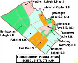
- Allentown School District
- William Allen High School, Allentown
- Louis E. Dieruff High School, Allentown
- Francis D. Raub Middle School
- Harrison-Morton Middle School
- South Mountain Middle School
- Trexler Middle School
- Catasauqua Area School District
- Catasauqua High School, Northampton
- Catasauqua Middle School
- East Penn School District
- Emmaus High School, Emmaus
- Eyer Middle School, Macungie
- Lower Macungie Middle School, Macungie
- Northern Lehigh School District
- Northern Lehigh High School, Slatington
- Northern Lehigh Middle School, Slatington
- Northwestern Lehigh School District
- Northwestern Lehigh High School, New Tripoli
- Parkland School District
- Parkland High School, South Whitehall Township
- Orefield Middle School, Orefield
- Springhouse Middle School, Allentown
- Salisbury Township School District
- Salisbury High School, Salisbury Township
- Salisbury Middle School
- Southern Lehigh School District
- Southern Lehigh High School, Center Valley
- Whitehall-Coplay School District
- Whitehall High School, Whitehall Township
- Whitehall-Coplay Middle School
Public charter schools
- Lincoln Leadership Academy Charter School, Allentown
- Roberto Clemente Charter School, Allentown
- Seven Generations Charter School, Emmaus
Private high schools
- Allentown Central Catholic High School, Allentown
- Lehigh Career and Technical Institute, Schnecksville
- Lehigh Valley Christian High School, Allentown
- Salem Christian School, Macungie
Transportation
Air
Lehigh County's primary airport, Lehigh Valley International Airport (IATA: ABE, ICAO: KABE), is located three miles (4.8 km) northeast of Allentown in Hanover Township.
The county is also served by Allentown Queen City Municipal Airport, a two-runway general aviation facility located off of Allentown's Lehigh Street. Queen City is used predominantly by private aviation that was awarded General Aviation Airport of the year by the Eastern Region of the Federal Aviation Administration in 2006.[25]
Bus
Public bus service in Lehigh County is available through the Lehigh and Northampton Transportation Authority, known as LANTA. Several private bus lines, including Fullington Trailways and Trans-Bridge Lines, provide bus service from Allentown to New York City's Port Authority Bus Terminal, Philadelphia's Greyhound Terminal, Atlantic City's Bus Terminal, and other regional locations.
Major highways
 I-78
I-78
 I-476 / Penna Turnpike NE Extension
 US 22
US 22 US 222
 PA 29
PA 29 PA 100
 PA 143
 PA 145
 PA 222
 PA 309
 PA 329
 PA 378
 PA 863
 PA 873
 PA 987
- Cedar Crest Boulevard
- Lehigh Street
- Tilghman Street
Media
The Lehigh County is part of the Philadelphia broadcast media market, though numerous New York City radio and television stations also are available in Allentown and its suburbs. Lehigh County-based media include The Morning Call, a daily newspaper in Allentown, and two Allentown television stations: WLVT Channel 39 (a PBS affiliate) and WFMZ Channel 69 (an unaffiliated, independent television station).
Television
The four major Philadelphia-based network stations serving Lehigh County include KYW-TV (CBS), WCAU (NBC), WPVI (ABC) and WTXF (Fox). The four major Scranton/Wilkes-Barre-based network stations serving Lehigh County are WNEP-TV (ABC), WBRE-TV (NBC), WYOU (CBS), and WOLF-TV (Fox) The four major New York City-based network stations serving Lehigh County include WABC (ABC), WCBS-TV (CBS), WNBC (NBC), and WNYW (Fox). Lehigh Valley-based television outlets include WFMZ-TV Channel 69 (an Allentown independent station), WBPH-TV Channel 60, and WLVT-TV (a Bethlehem PBS affiliate).
Print
The primary newspaper for the county is The Morning Call, based in Allentown. The Express-Times, based in Easton, and Times News, based in Lehighton, also cover portions of the county.
Radio
Lehigh County-area radio stations include WAEB-AM, a news, talk and sports station (in Allentown), WAEB-FM (known as B104), a Top 40 music station (in Allentown), WZZO, a hard rock music station (in Whitehall Township), and others. Some major New York City stations and every major Philadelphia station also can be heard in the county.
Telecommunications
Lehigh County was once served only by the 215 area code from 1947 (when the North American Numbering Plan of the Bell System went into effect) until 1994. With the county's growing population, however, Lehigh County areas were afforded area code 610 in 1994. Today, Lehigh County is covered by 610. An overlay area code, 484, was added to the 610 service area in 1999.[26] A plan to introduce area code 835 as an additional overlay was rescinded in 2001.[27]
Recreation
Most municipalities in the county have set aside at least some land for public recreation, from neighborhood parks and playgrounds to the more expansive parkways developed by the county, city and several townships. Following are the public parks within the county of more than of 25 acres (100,000 m2), including listings of their primary activities:
- Big Rock Park, Salisbury and Upper Saucon Townships, 77-acre County-owned park atop Lehigh Mountain that is one of the few places in the county south of Blue Mountain exceeding 1000 feet in elevation. Access is from East Rock Road. Activities: hiking/walking, nature study, and picnicking.
- Cedar Creek Parkway, Allentown, 127 acres (0.51 km2). City-owned park along Cedar Creek that includes Lake Muhlenberg and Malcolm W. Gross Rose Gardens. Activities: hiking/walking, jogging, basketball, fishing, swimming and picnicking. "Blues, Brews, and Barbeque," which launched in 2014, is held annually at Cedar Beach Park.[29][30][31]
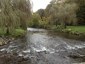
- Cedar Creek Parkway East, South Whitehall Township, 37.5 acres (152,000 m2). County-owned park along Cedar Creek that includes Haines Mill Museum. Activities: hiking/walking, soccer, fishing, nature study and picnicking.
- Cedar Creek Parkway West, South Whitehall Township, 261 acres (1.06 km2). County-owned park along Cedar Creek. Activities: hiking/walking, jogging, baseball, softball, soccer, tennis, basketball, swimming, nature study and picnicking.
- Covered Bridge Park, South Whitehall Township, 165 acres (0.67 km2). Township-owned park along Jordan Creek that includes two historic covered bridges. Activities: hiking/walking, jogging, football, soccer fields, volleyball, handball, fishing, disc golf, playground and nature study.
- Jordan Creek Parkway, Whitehall & South Whitehall Townships, 296.1 acres (1.198 km2). County-owned park along Jordan Creek. Activities: hiking/walking, jogging, bicycling, softball, baseball, soccer, tennis, fishing, cross country skiing and nature study.

- Leaser Lake, Lynn Township, 540.5 acres (2.187 km2). County-owned park (227.6 acres (0.921 km2)) and Pennsylvania Fish Commission-owned (312.9-acre (1.266 km2)) recreation area that includes a 117-acre (0.47 km2) lake. Activities: hiking/walking, fishing, hunting, boating (sail, other non-motor and small electric motor), cross country skiing, ice-skating, nature study and picnicking.
- Lehigh Canal Park, Allentown, 55 acres (220,000 m2). City-owned park along the Lehigh River. Activities: hiking/walking, fishing and non-motor boating.
- Lehigh Parkway, Allentown, 999 acres (4.04 km2). City-owned park along Little Lehigh Creek that also includes the Lil-Le-Hi Trout Nursery. Activities: hiking/walking, bicycling, fishing, disc golf, nature study and picnicking.
- Lock Ridge Park, Alburtis, 59.2 acres (240,000 m2). County-owned park along Swabia Creek that includes the Lock Ridge Furnace Museum. Activities: hiking/walking, baseball, bicycling, fishing, cross country skiing, nature study and picnicking.
- Lower Macungie Township Community Park, Lower Macungie township, 56 acres (230,000 m2). Township-owned park along Spring Creek. Activities: hiking/walking, jogging, soccer and picnicking.
- Bob Rodale Cycling and Fitness Park, Upper Macungie Township, 103.4 acres (0.418 km2). County-owned bicycle track and fitness area. Activities: Hiking/walking, bicycling, softball, cricket, soccer, basketball, cross country skiing, roller blading, jogging, nature study, playground and picnicking.
- Trexler Memorial Park, Allentown, 134 acres (0.54 km2). City-owned park along Cedar Creek. Activities: hiking/walking, jogging and nature study.
- Trexler Nature Preserve, North Whitehall Township, 1,108 acres (4.48 km2). County-owned park along Jordan Creek, formerly Trexler-Lehigh County Game Preserve, which includes the Lehigh Valley Zoo and is adding 18 miles (29 km) of trails in 2010. Activities: hiking/walking, mountain biking, jogging, fishing, hunting, nature study and picnicking.
- Upper Macungie Park, Upper Macungie Township, 156.2 acres (0.632 km2). Township-owned park with nature trail. Activities: hiking/walking, baseball, softball, sand volleyball, horse shoes, playground, jogging, nature study and picnicking.
- Whitehall Parkway, Whitehall Township, 110 acres (0.45 km2). Township-owned park connected to the nine-mile (14 km) Ironton Rail-Trail. Activities: hiking/walking, bicycling, jogging and nature study.
Communities
.
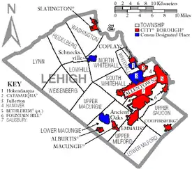
Under Pennsylvania law, there are four types of incorporated municipalities: cities, boroughs, townships, and, in only one case, towns. The following cities, boroughs and townships are located in Lehigh County:
Cities
- Allentown (county seat)
- Bethlehem (mostly in Northampton County)
Townships
- Hanover Township
- Heidelberg Township
- Lower Macungie Township
- Lower Milford Township
- Lowhill Township
- Lynn Township
- North Whitehall Township
- Salisbury Township
- South Whitehall Township
- Upper Macungie Township
- Upper Milford Township
- Upper Saucon Township
- Washington Township
- Weisenberg Township
- Whitehall Township
Census-designated places
Census-designated places are geographical areas designated by the U.S. Census Bureau for the purposes of compiling demographic data. They are not actual jurisdictions under Pennsylvania law. Other unincorporated communities, such as villages, may be listed here as well.
Unincorporated communities
- Balliettsville
- Center Valley
- Colesville
- East Texas
- Emerald
- Evergreen Park
- Fogelsville
- Friedensville
- Gauff Hill
- Germansville
- Guthsville
- Hensingersville
- Hosensack
- Ironton
- Kuhnsville
- Lanark
- Limeport
- Locust Valley
- Lynnport
- Mechanicsville
- Meyersville
- Neffs
- New Smithville
- Old Zionsville
- Orefield
- Pleasant Corners
- Powder Valley
- Scherersville
- Schoenersville
- Shimerville
- Summit Lawn
- Vera Cruz
- Walbert
- Wanamakers
- Werleys Corner
- West Catasauqua
- Zionsville
Population ranking
The population ranking of the following table is based on the 2010 census of Lehigh County.[32]
† county seat
| Rank | City/Town/etc. | Municipal type | Population (2010 Census) |
|---|---|---|---|
| 1 | † Allentown | City | 118,032 |
| 2 | Bethlehem (mostly in Northampton County) | City | 74,982 |
| 4 | Emmaus | Borough | 11,211 |
| 5 | Ancient Oaks | CDP | 6,661 |
| 6 | Catasauqua | Borough | 6,436 |
| 7 | Wescosville | CDP | 5,872 |
| 8 | Fountain Hill | Borough | 4,597 |
| 9 | Dorneyville | CDP | 4,406 |
| 10 | Slatington | Borough | 4,232 |
| 11 | Breinigsville | CDP | 4,138 |
| 13 | Coplay | Borough | 3,192 |
| 14 | Macungie | Borough | 3,074 |
| 15 | Schnecksville | CDP | 2,935 |
| 17 | Coopersburg | Borough | 2,386 |
| 18 | Alburtis | Borough | 2,361 |
| 19 | Cetronia | CDP | 2,115 |
| 20 | Trexlertown | CDP | 1,988 |
| 22 | Laurys Station | CDP | 1,243 |
| 24 | DeSales University | CDP | 953 |
| 25 | New Tripoli | CDP | 898 |
| 26 | Slatedale | CDP | 455 |
Notable people
Lehigh County is the birthplace of, or home to, several notable Americans, including:
- Chuck Bednarik, former professional football player, Philadelphia Eagles, and member of Pro Football Hall of Fame
- Stephen Vincent Benét, author
- Michaela Conlin, stage and television actress, Bones
- Charlie Dent, Member of Congress
- H.D., writer
- Peter Gruner, professional wrestler
- Lee Iacocca, former chairman of Chrysler Corporation
- Keith Jarrett, jazz musician
- Michael Johns, health care executive and former White House speechwriter
- Carson Kressley, fashion consultant on Bravo's Queer Eye
- Rose Lambert, American missionary and witness of the Adana massacre
- Varvara Lepchenko, professional tennis player
- Lil Peep, American rapper, singer, and song writer (formally known as Gustav Elijah Åhr)
- Matt Millen, former professional football player, Oakland Raiders, San Francisco 49ers and Washington Redskins, and former President and General Manager, Detroit Lions
- Andre Reed, former professional football player, Buffalo Bills and Washington Redskins
- Amanda Seyfried, model and actress, The CW's Veronica Mars and HBO's Big Love
- Curt Simmons, former professional baseball player, California Angels, Chicago Cubs, Philadelphia Phillies and St. Louis Cardinals
- Dana Snyder, voice actor, Adult Swim's Aqua Teen Hunger Force
- Albert Solliday, Wisconsin State Senator
- Christine Taylor, actress and wife of actor Ben Stiller
- Lauren Weisberger, author of The Devil Wears Prada
See also
Notes
- Mean monthly maxima and minima (i.e. the highest and lowest temperature readings during an entire month or year) calculated based on data at said location from 1981 to 2010.
- Official records for Allentown were kept at Allentown Gas Company from March 1922 to December 1943, and at Lehigh Valley Int'l since January 1944. For more information, see ThreadEx.
References
- "State & County QuickFacts". United States Census Bureau. Archived from the original on June 6, 2011. Retrieved November 17, 2013.
- "Find a County". National Association of Counties. Retrieved 2011-06-07.
- Roberts, Charles R. (1936). "Place Names of Lehigh County and Their Origin". Proceedings: Lehigh County Historical Society. Lehigh County Historical Society.
- Kraus, Scott (April 2, 2016). "Migration driving Lehigh Valley's recent population growth". The Morning Call. Retrieved May 17, 2017.
- "2010 Census Gazetteer Files". United States Census Bureau. August 22, 2012. Retrieved March 9, 2015.
- Miller, Benjamin LeRoy (1941). Lehigh County Pennsylvania: Geology and Geography. Harrisburg, Pennsylvania: Department of Internal Affairs, Commonwealth of Pennsylvania.
- "Normal Monthly Precipitation, Inches". Archived from the original on September 19, 2006. Retrieved 2006-11-04.
- "Interactive Map," USDA
- "Snowfall – Average Total In Inches". Archived from the original on 2011-06-19. Retrieved 2006-11-04.
- "Average Days of Precipitation, .01 cm or more". Archived from the original on November 3, 2006. Retrieved 2006-11-04.
- "Average Monthly Precipitation". Archived from the original on September 19, 2006. Retrieved 2006-11-04.
- "NowData - NOAA Online Weather Data". National Oceanic and Atmospheric Administration. Retrieved 2019-10-03.
- "Station Name: PA ALLENTOWN LEHIGH VALLEY INTL AP". National Oceanic and Atmospheric Administration. Retrieved 2019-10-03.
- "WMO Climate Normals for ALLENTOWN/A.-BETHLEHEM, PA 1961–1990". National Oceanic and Atmospheric Administration. Retrieved 2014-05-28.
- "Population and Housing Unit Estimates". Retrieved March 26, 2020.
- "U.S. Decennial Census". United States Census Bureau. Retrieved March 9, 2015.
- "Historical Census Browser". University of Virginia Library. Retrieved March 9, 2015.
- Forstall, Richard L., ed. (March 24, 1995). "Population of Counties by Decennial Census: 1900 to 1990". United States Census Bureau. Retrieved March 9, 2015.
- "Census 2000 PHC-T-4. Ranking Tables for Counties: 1990 and 2000" (PDF). United States Census Bureau. April 2, 2001. Retrieved March 9, 2015.
- "U.S. Census website". United States Census Bureau. Retrieved 2008-01-31.
- Pennsylvania Department of State Archived 2008-11-26 at the Wayback Machine
- "Election Results 2008: President Map". New York Times. 2008-11-21. Retrieved 2008-11-23.
- Leip, David. "Dave Leip's Atlas of U.S. Presidential Elections". uselectionatlas.org.
- Center, Legislativate Data Processing. "Find Your Legislator". The official website for the Pennsylvania General Assembly. Retrieved 2017-04-21.
- "Queen City Airport Designated General Aviation Airport of the Year by the Federal Administration Eastern Region". Lehigh Valley International Airport. Archived from the original on 2007-06-12. Retrieved 2007-06-22.
- "NANP-Overlay of 610 (Pennsylvania) Numbering Plan Area (NPA) with 484 NPA" (PDF). (359 KB)
- "PA 835 Implementation for 484/610 NPA Rescinded – 835 NPA Code Reclaimed" (PDF). (20.8 KB)
- "Rollercoaster Database: Steel Force (Dorney Park & Wildwater Kingdom)". Retrieved 2008-07-10.
- "Downtown Allentown Business Alliance - welcome to downtownallentown.com your Lehigh Valley destination for downtown Allentown PPL events, entertainment, dining and arts". www.downtownallentown.com. Archived from the original on 2019-02-11. Retrieved 2019-02-12.
- News, 69 (2018-05-27). "Allentown Fairgrounds holds Music and Arts Celebration". WFMZ. Retrieved 2019-02-12.CS1 maint: numeric names: authors list (link)
- Call, The Morning. "Allentown ArtsFest brings alternative entertainment and fun for the fifth year". themorningcall.com. Retrieved 2019-02-12.
- "2010 U.S. Census website". United States Census Bureau. Retrieved 2016-07-10.
External links
| Wikivoyage has a travel guide for Lehigh County, PA. |
![]() Media related to Lehigh County, Pennsylvania at Wikimedia Commons
Media related to Lehigh County, Pennsylvania at Wikimedia Commons
- Lehigh County Government Official Web Site
- Lehigh County news at The (Allentown) Morning Call
- "Famous People from the Lehigh Valley," The Baltimore Sun
Places adjacent to Lehigh County, Pennsylvania | |
|---|---|
Municipalities and communities of Lehigh County, Pennsylvania, United States | ||
|---|---|---|
| Cities | | |
| Boroughs | ||
| Townships | ||
| CDPs | ||
| Unincorporated communities |
| |
| Footnotes | ‡This populated place also has portions in an adjacent county or counties | |
| ||

| Authority control |
|---|