Lenzspitze
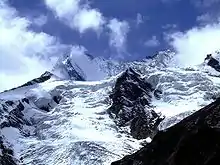
The Lenzspitze is a 4,294-metre (14,088 ft) mountain in the Pennine Alps in Switzerland. It is the southernmost peak on the Nadelgrat, a high-level ridge running roughly north–south, north of Dom in the Mischabel range, above the resort of Saas Fee to the east, and the Mattertal to the west.[2]
| Lenzspitze | |
|---|---|
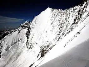 Northeast face | |
| Highest point | |
| Elevation | 4,294 m (14,088 ft) |
| Prominence | 86 m ↓ Nadeljoch [1] |
| Parent peak | Nadelhorn |
| Isolation | 0.61 km → Nadelhorn [1] |
| Coordinates | 46°06′16.7″N 7°52′06.4″E |
| Geography | |
 Lenzspitze Location in Switzerland | |
| Location | Switzerland |
| Parent range | Pennine Alps |
| Climbing | |
| First ascent | August 1870 by Clinton Thomas Dent, Alexander Burgener and Franz Burgener |
| Easiest route | South-west ridge (west flank) Mixed at PD |
Ascent
It was first climbed in August 1870 by Clinton Thomas Dent with guide Alexander Burgener and a porter, Franz Burgener, by the north-east face to the Nadeljoch and then the north-west ridge to the summit. This route is rarely used today.
The east-north-east ridge starts at the Mischabel Hut. This ridge was first climbed on 3 August 1882 by William Woodman Goodman with guides Ambros Supersaxo and Theodor Andenmatten.
Its north-east face is a classic ice climb, comprising a 500-metre (1,600 ft) wall of ice or neve at an angle of up to 56 degrees, first climbed by Dietrich von Bethmann-Hollweg with Oskar and Othmar Supersaxo on 7 July 1911. This face was descended on skis by Heini Holzer on 22 July 1972.
See also
References
- Lenzspitze, Switzerland at peakbagger.com, retrieved 20 February 2016
- "Switzerland Travel".
Bibliography
- Dumler, Helmut; Burkhardt, Willi P. (1994). The High Mountains of the Alps. London: Diadem.CS1 maint: ref=harv (link)