Strahlhorn
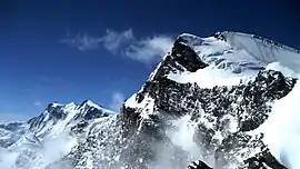
The Strahlhorn (4,190 m) is a mountain of the Swiss Pennine Alps, located south of Saas-Fee and east of Zermatt in the canton of Valais. It lies on the range that separates the Mattertal from the Saastal and is located approximately halfway between the Rimpfischhorn and the Schwarzberghorn.
| Strahlhorn | |
|---|---|
 | |
| Highest point | |
| Elevation | 4,190 m (13,750 ft) |
| Prominence | 401 m (1,316 ft) [1] |
| Parent peak | Rimpfischhorn |
| Isolation | 1.8 km (1.1 mi) |
| Coordinates | 46°00′47.6″N 7°54′06.3″E |
| Geography | |
 Strahlhorn Location in Switzerland | |
| Location | Valais |
| Country | Switzerland |
| Parent range | Pennine Alps |
| Topo map | Swiss Federal Office of Topography swisstopo |
| Climbing | |
| First ascent | 15 August 1854 by Christopher Smyth, Ulrich Lauener, Edmund J. Grenville and Franz-Josef Andenmatten |
| Easiest route | Basic snow climb |
There are three less known peaks of the same name in Switzerland (3027m, 3194m, 3200m).[2]
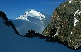
Monte Rosa and Strahlhorn (right)
See also
References
- Retrieved from the Swisstopo topographic maps. The key col is the Adlerpass (3,789 m).
- "Gipfel der Schweiz - Gipfel - Liste". www.gipfelderschweiz.ch.
Sources
- Dumler, Helmut and Willi P. Burkhardt, The High Mountains of the Alps, London: Diadem, 1994
External links
| Wikimedia Commons has media related to Strahlhorn. |
- "Strahlhorn". SummitPost.org.
- Strahlhorn on Hikr
This article is issued from Wikipedia. The text is licensed under Creative Commons - Attribution - Sharealike. Additional terms may apply for the media files.