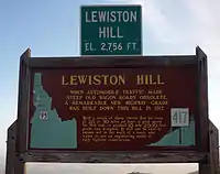
Lewiston Hill
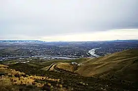
Lewiston Hill is a large sloping escarpment north of the confluence of the Clearwater River (Idaho) and the Snake River. Residents of the nearby cities of Lewiston, Idaho and Clarkston, Washington typically refer to "Lewiston Hill" as the mostly-unfarmed land north of the city limits of the respective cities, but still remaining visible from the cities. At the top of the escarpment is a grain farming region known as "the Palouse". The border between Lewiston Hill and the Palouse is at an approximate elevation of 2,756 feet (840 m), as measured at a rest area at the junction of U.S. Route 195 and U.S. Route 95 in Idaho. Lower Granite Lake at the foot of the hill, and at the confluence of the Clearwater River and the Snake River has a typical surface elevation of 741 feet (226 m).[1]
| Lewiston Hill | |
|---|---|
 photograph taken 2006 | |
| Elevation | 2,756 ft (840 m) |
| Length | 5.3 miles (8.5 km) |
| Traversed by | |
| Max gradient | 7 % |
| Location | Nez Perce County, Idaho, U.S. |
| Coordinates | 46.460246°N 117.016264°W |
Highways
.jpg.webp)
Old Spiral Highway
.jpg.webp)
Branching off of Idaho State Highway 128 (just east of the Washington-Idaho transition from Washington State Route 128), the "Old Spiral Highway" and former 10-mile segment of U.S. Route 95 in Idaho climbs 2,000 vertical feet (610 m) of the riverbank north of the confluence of the Snake and the Clearwater Rivers. The summit is at (elev. 2,756 ft (840 m)), following a very twisty road (64 curves) that was opened in 1917. It was the primary route north until it was replaced sixty years later, and received an award as one of the best-engineered stretches of mountain highway at the time. It was decommissioned in 1977, when it was replaced by the current alignment of U.S. Route 95 in Idaho
The 1950s rock and roll hit by singer-songwriter Charlie Ryan titled "Hot Rod Lincoln" tells of an actual race on that hill. The lyrics of the song were changed variously to say San Pedro or The Grapevine in later versions, but the Ryan claimed at later performances that he was inspired by Lewiston Hill.[2]
The north end of the Old Spiral Highway joins with U.S. Route 95 in Idaho and U.S. Route 195 on the Washington-Idaho border.
U.S. Route 95 up Lewiston Hill
The newer multi-lane grade of U.S. Route 95 ascending the slope to the north of Lewiston is often simply referred to as "Lewiston Hill" by local residents.[3] It was constructed from 1975 to 1977, yields a straighter and steeper sweeping "Z" descent to the east, then back to the southwest, and is approximately seven miles (11 km) in length.[4]
Scenery
Both grades provide excellent views of the Lewiston-Clarkston area and beyond.
References
- "File:LewistonHillSignSept2010.jpg", Wikipedia, 2011-12-30, retrieved 2020-12-12
- Johnson, David (June 27, 2003). "That hot rod Lincoln". Lewiston Morning Tribune. Retrieved 2020-12-11.
- Stovall, Scott (2014-12-04). "Lewiston Hill resurfacing project begins this spring". KLEW-TV. Retrieved 2020-12-12.
- Harrell, Sylvia (October 27, 1977). "What a way to go!". Lewiston Morning Tribune. p. 1D. Archived from the original on November 23, 2015. Retrieved November 22, 2015.