List of Cascade Range topics
This article contains a list of volcanoes and a list of protected areas associated with the Cascade Range of the Pacific Northwest of North America.
Volcanoes
Volcanoes south of the Fraser River in the Cascade Volcanic Arc (a geological term) belong to the Cascade Range (a geographic term). Peaks are listed north to south.
North Cascades

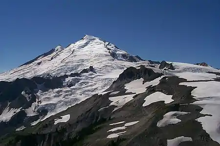
Mount Baker
- Coquihalla Mountain (southern British Columbia) — highest peak in the Bedded Range. It is a major preserved stratovolcano in the Pemberton Volcanic Belt, an extinct portion of the Canadian Cascade Arc.[1]
- Mount Baker (Near the United States-Canada border) — highest peak in northern Washington. It is an active volcano.[2] Steam activity from its crater occurs relatively frequently. Mount Baker is one of the snowiest places on Earth; in 1999 the ski area (on a subsidiary peak) recorded the world's greatest single-season snowfall: 1,140 in (29,000 mm).
- Glacier Peak (northern Washington) — secluded and relatively inaccessible peak. Contrary to its name, its glacial cover is not that extensive. The volcano is surprisingly small in volume, and gets most of its height by having grown atop a nonvolcanic ridge.
High Cascades

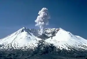
1982 minor eruption of Mount St. Helens
- Mount Rainier (southeast of Tacoma, Washington) — highest peak in the Cascades, it dominates the surrounding landscape. There is no other higher peak northward until the Yukon-Alaska-BC border apex beyond the Alsek River.
- Mount St. Helens (southern Washington) — Erupted in 1980, leveling forests to the north of the mountain and sending ash across the northwest. The northern part of the mountain was destroyed in the blast (1980 Mount St. Helens eruption).
- Mount Adams (east of Mount St. Helens) — the second highest peak in Washington and third highest in the Cascade Range.
- Mount Hood (northern Oregon) — the highest peak in Oregon and arguably the most frequently climbed major peak in the Cascades.
- Mount Jefferson (northcentral Oregon) — the second highest peak in Oregon.
- Three Fingered Jack (northcentral Oregon) — Highly eroded Pleistocene volcano.
- Mount Washington (between Santiam and McKenzie passes) — a highly eroded shield volcano.[3]
- Three Sisters (near the city of Bend, Oregon) — South Sister is the highest and youngest, with a well-defined crater. Middle Sister is more pyramidal and eroded. North Sister is the oldest and has a crumbling rock pinnacle.
- Broken Top (to the southeast of South Sister) — a highly eroded extinct stratovolcano. Contains Bend and Crook Glaciers.
- Newberry Volcano — isolated caldera with two crater lakes. Very variable lavas. Flows from here have reached the city of Bend.
- Mount Bachelor (near Three Sisters) — a geologically young (less than 15,000 years) shield-to-stratovolcano which is now the site of a popular ski resort. (Mt. Bachelor ski area)
- Diamond Peak (south of Willamette Pass) — a 8,744 ft (2,665 m) volcano composed of 15 km3 (3.6 cu mi) of basaltic andesite.
- Mount Bailey (north of Mount Mazama)
- Mount Thielsen (east of Mount Bailey) — highly eroded volcano with a prominent spire, making it the Lightning Rod of the Cascades.
- Mount Mazama (southern Oregon) — better known for its Crater Lake, which is a caldera formed by a catastrophic eruption which took out most of the summit roughly 6,900 years ago. Mount Mazama is estimated to have been about 11,000 ft (3,400 m) elevation prior to the blast.
- Mount Scott (southern Oregon) — on the southeastern flank of Crater Lake. At 8,929 ft (2,722 m) elevation, this small stratovolcano is the highest peak in Crater Lake National Park.
- Mount McLoughlin (near Klamath Falls, Oregon) — presents a symmetrical appearance when viewed from Klamath Lake.
- Medicine Lake Volcano — a shield volcano in northern California which is the largest volcano by volume in the Cascades.
- Mount Shasta (northern California) — second highest peak in the Cascades. Can be seen in the Sacramento Valley as far as 140 mi (230 km) away, as it is a dominating feature of the region.
- Lassen Peak (south of Mount Shasta) — southernmost volcano in the Cascades and the most easily climbed peak in the Cascades. It erupted from 1914 to 1921, and like Mount Shasta, it too can be seen in the Sacramento Valley, up to 120 mi (190 km) away. Lowest Peak because the Cascades extend from it.

Protected areas

Three Fingered Jack and Santiam Pass, Oregon
There are four U.S. National Parks in the Cascade Range, one National Scenic Area, and many U.S. National Monuments, U.S. Wilderness Areas, and U.S. National Forests. Each classification protects the various glaciers, volcanoes, geothermal fields, rivers, lakes, forests, and wildlife to varying degrees.
National parks
- Lassen Volcanic National Park was established in 1916 while its namesake peak was erupting. The park includes the most extensive and active thermal areas in the United States outside Yellowstone National Park.
- Crater Lake National Park preserves the remains of Mount Mazama, a large volcano that imploded thousands of years ago, forming a caldera that was later filled with rain and ground water, later to be known as Crater Lake.
- Mount Rainier National Park surrounds the Cascades' highest volcano, Mount Rainier, which in turn is covered by the largest glacier system in the United States south of Alaska.
- North Cascades National Park was carved out of a primitive part of the range composed of ancient metamorphic and sedimentary rock. Mount Baker and Glacier Peak are nearby.
National Scenic Areas
National monuments
- Mount St. Helens National Volcanic Monument was formed following the 1980 eruption of Mount St. Helens in order to preserve the devastated area and give scientists a chance to study its recovery.
- Newberry National Volcanic Monument includes the area around Newberry Volcano in central Oregon.
- Cascade–Siskiyou National Monument is located in southern Oregon at the junction of the Cascades and the Siskiyou Mountains.
- Lava Beds National Monument in California lies on the northeast flank of the Medicine Lake Volcano and is the site of the largest concentration of lava tubes in the United States.
Provincial Parks
- Skagit Valley Provincial Park
- E.C. Manning Provincial Park
- Cascade Recreation Area
- Cathedral Provincial Park and Protected Area
- Coquihalla Canyon Provincial Park
- Chilliwack Lake Provincial Park
- Coquihalla Summit Recreation Area
- Silver Lake Provincial Park
- Nicolum River Provincial Park
- Skihist Provincial Park
- Bridal Veil Falls Provincial Park
- Cultus Lake Provincial Park
Wilderness areas

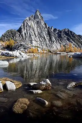
Gnome tarn, The Enchantments, Alpine Lakes Wilderness
- Wenatchee National Forest Wilderness Areas
- Gifford Pinchot National Forest Wilderness Areas
- Mount Baker-Snoqualmie National Forest Wilderness Areas
- Mount Hood National Forest Wilderness Areas
- Deschutes National Forest Wilderness Areas
- Willamette National Forest Wilderness Areas
- Umpqua National Forest Wilderness Areas
- Rogue River – Siskiyou National Forest Wilderness Areas
- Fremont–Winema National Forests Wilderness Areas
- Shasta-Trinity National Forest Wilderness Areas
- Lassen National Forest Wilderness Areas
Natural history
- Cascades Ecoregion
- Ecology of the North Cascades
- Flora of the Cascade Range
| Wikimedia Commons has media related to: |
References
- Monger, J.W.H. (1994). "Character of volcanism, volcanic hazards, and risk, northern end of the Cascade magmatic arc, British Columbia and Washington State". Geology and Geological Hazards of the Vancouver Region, Southwestern British Columbia. Ottawa, Ontario: Natural Resources Canada. p. 235. ISBN 0-660-15784-5.
- Scott, Kevin M.; Wes Hildreth; Cynthia A. Gardner (2005-05-25). Mount Baker-Living with an Active Volcano: U.S. Geological Survey Fact Sheet 059-00. United States Geological Survey.
- "Mount Washington Wilderness, Willamette National Forest, Oregon". Wildernet.com.
This article is issued from Wikipedia. The text is licensed under Creative Commons - Attribution - Sharealike. Additional terms may apply for the media files.

