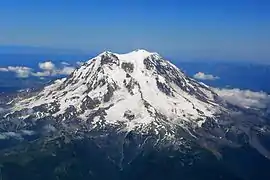
Mount Baker
Mount Baker (Lummi: Qwú’mə Kwəlshéːn; Nooksack: Kw’eq Smaenit or Kwelshán), also known as Koma Kulshan or simply Kulshan, is a 10,781 ft (3,286 m) active[9] glacier-covered andesitic stratovolcano[5] in the Cascade Volcanic Arc and the North Cascades of Washington in the United States. Mount Baker has the second-most thermally active crater in the Cascade Range after Mount St. Helens.[10] About 30 miles (48 km)[11] due east of the city of Bellingham, Whatcom County, Mount Baker is the youngest volcano in the Mount Baker volcanic field.[4] While volcanism has persisted here for some 1.5 million years, the current volcanic cone is likely no more than 140,000 years old, and possibly no older than 80–90,000 years. Older volcanic edifices have mostly eroded away due to glaciation.
| Mount Baker | |
|---|---|
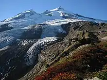
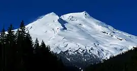 Mount Baker as seen from the Southeast at Boulder Creek | |
| Highest point | |
| Elevation | 10,781 ft (3,286 m) [1] |
| Prominence | 8,812 ft (2,686 m) [1] |
| Listing |
|
| Coordinates | 48°46′38″N 121°48′48″W [2] |
| Naming | |
| Etymology | Joseph Baker |
| Native name | Kulshan (Nooksack) |
| Geography | |
 Mount Baker Washington | |
| Location | Whatcom County, Washington, U.S. |
| Parent range | Cascade Range[3] |
| Topo map | USGS Mount Baker |
| Geology | |
| Age of rock | Less than 140,000 years[4] |
| Mountain type | Stratovolcano[5] |
| Volcanic arc | Cascade Volcanic Arc[3] |
| Last eruption | 7 September to 27 November 1880[6] |
| Climbing | |
| First ascent | 1868 by Edmund Coleman, John Tennant, Thomas Stratton and David Ogilvy[7][8] |
| Easiest route | snow (ice) climb |
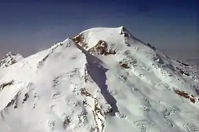
After Mount Rainier, Mount Baker has the heaviest glacier cover of the Cascade Range volcanoes; the volume of snow and ice on Mount Baker, 0.43 cu mi (1.79 km3) is greater than that of all the other Cascades volcanoes (except Rainier) combined. It is also one of the snowiest places in the world; in 1999, Mount Baker Ski Area, located 9 mi (14.5 km) to the northeast, set the world record for recorded snowfall in a single season—1,140 in (29 m; 95 ft).[12]
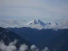
Mt. Baker is the third-highest mountain in Washington and the fifth-highest in the Cascade Range, if Little Tahoma Peak, a subpeak of Mount Rainier, and Shastina, a subpeak of Mount Shasta, are not counted.[5][13] Located in the Mount Baker Wilderness, it is visible from much of Greater Victoria, Nanaimo, and Greater Vancouver in British Columbia, and to the south, from Seattle (and on clear days Tacoma) in Washington.
Indigenous peoples have known the mountain for thousands of years, but the first written record of the mountain is from Spanish explorer Gonzalo Lopez de Haro, who mapped it in 1790 as Gran Montaña del Carmelo, "Great Mount Carmel".[14] The explorer George Vancouver renamed the mountain for 3rd Lieutenant Joseph Baker of HMS Discovery, who saw it on April 30, 1792.[15]
History
.jpg.webp)
Mount Baker was well-known to indigenous peoples of the Pacific Northwest. Indigenous names for the mountain include Koma Kulshan or Kulshan (Lummi: qwú’mə, "white sentinel", , and kwəlshé:n, "puncture wound", i.e. "crater");[16][17][18] Quck Sam-ik (Nooksack: kw’eq sámit, "white mountain");[19] Kobah (Skagit: qwúbə’, "white sentinel", and Tukullum or Nahcullum (in the language of the unidentified "Koma tribe").[20]
In 1790, Manuel Quimper of the Spanish Navy set sail from Nootka, a temporary settlement on Vancouver Island, with orders to explore the newly discovered Strait of Juan de Fuca. Accompanying Quimper was first-pilot Gonzalo Lopez de Haro, who drew detailed charts during the six-week expedition. Although Quimper's journal of the voyage does not refer to the mountain, one of Haro's manuscript charts includes a sketch of Mount Baker.[21][22] The Spanish named the snowy volcano La Gran Montana del Carmelo, as it reminded them of the white-clad monks of the Carmelite Monastery.[23]
The British explorer George Vancouver left England a year later. His mission was to survey the northwest coast of America. Vancouver and his crew reached the Pacific Northwest coast in 1792. While anchored in Dungeness Bay on the south shore of the Strait of Juan de Fuca, Joseph Baker made an observation of Mount Baker, which Vancouver recorded in his journal:
About this time a very high conspicuous craggy mountain ... presented itself, towering above the clouds: as low down as they allowed it to be visible it was covered with snow; and south of it, was a long ridge of very rugged snowy mountains, much less elevated, which seemed to stretch to a considerable distance ... the high distant land formed, as already observed, like detached islands, amongst which the lofty mountain, discovered in the afternoon by the third lieutenant, and in compliment to him called by me Mount Baker, rose a very conspicuous object ... apparently at a very remote distance.[22]
Six years later, the official narrative of this voyage was published, including the first printed reference to the mountain.[22] By the mid-1850s, Mount Baker was a well-known feature on the horizon to the explorers and fur traders who traveled in the Puget Sound region. Isaac I. Stevens, the first governor of Washington Territory, wrote about Mount Baker in 1853:
Mount Baker ... is one of the loftiest and most conspicuous peaks of the northern Cascade range; it is nearly as high as Mount Rainier, and like that mountain, its snow-covered pyramid has the form of a sugar-loaf. It is visible from all the water and islands ... [in Puget Sound] and from the whole southeastern part of the Gulf of Georgia, and likewise from the eastern division of the Strait of Juan de Fuca. It is for this region a natural and important landmark.[22]
Climbing history
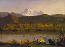
First European ascent
Edmund Thomas Coleman, an Englishman who resided in Victoria, British Columbia, Canada and a veteran of the Alps, made the first attempt to ascend the mountain in 1866. He chose a route via the Skagit River, but was forced to turn back when local Native Americans refused him passage.[14]
Later that same year, Coleman recruited Whatcom County settlers Edward Eldridge, John Bennett, and John Tennant to aid him in his second attempt to scale the mountain. After approaching via the North Fork of the Nooksack River, the party navigated through what is now known as Coleman Glacier and ascended to within several hundred feet of the summit before turning back in the face of an "overhanging cornice of ice" and threatening weather.[14] Coleman later returned to the mountain after two years. At 4:00 pm on August 17, 1868, Coleman, Eldridge, Tennant and two new companions (David Ogilvy and Thomas Stratton) scaled the summit via the Middle Fork Nooksack River, Marmot Ridge, Coleman Glacier, and the north margin of the Roman Wall.[14]
Notable ascents
- 1948 North Ridge (AD, AI 2-3, 3700 feet) Fred Beckey, Ralph and Dick Widrig (August 1948)[24]
Geology
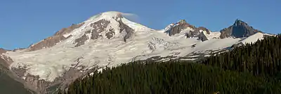
The present-day cone of Mount Baker is relatively young; it is perhaps less than 100,000 years old.[4] The volcano sits atop a similar older volcanic cone called Black Buttes, which was active between 500,000 and 300,000 years ago.[25] Much of Mount Baker's earlier geological record eroded away during the last ice age (which culminated 15,000–20,000 years ago), by thick ice sheets that filled the valleys and surrounded the volcano. In the last 14,000 years, the area around the mountain has been largely ice-free, but the mountain itself remains heavily covered with snow and ice.[26]
Isolated ridges of lava and hydrothermally altered rock, especially in the area of Sherman Crater, are exposed between glaciers on the upper flanks of the volcano; the lower flanks are steep and heavily vegetated. Volcanic rocks of Mount Baker and Black Buttes rest on a foundation of non-volcanic rocks.[4]
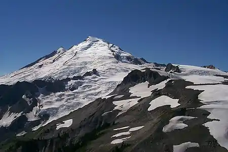
Deposits recording the last 14,000 years at Mount Baker indicate that Mount Baker has not had highly explosive eruptions like those of other volcanoes in the Cascade Volcanic Arc, such as Mount St. Helens, Glacier Peak, or the Mount Meager massif, nor has it erupted frequently. During this period, four episodes of magmatic eruptive activity have been recently recognized.[27][28]
Magmatic eruptions have produced tephra, pyroclastic flows, and lava flows from summit vents and the Schriebers Meadow Cone. The most destructive and most frequent events at Mount Baker have been lahars or debris flows and debris avalanches; many, if not most, of these were not related to magmatic eruptions, but may have been induced by magma intrusion, steam eruptions, earthquakes, gravitational instability, or possibly even heavy rainfall.[26][27][29]
Early history
Research beginning in the late 1990s shows that Mount Baker is the youngest of several volcanic centers in the area and one of the youngest volcanoes in the Cascade Range.[4][29] The Pliocene Hannegan caldera is preserved 16 miles (25 km) northeast of Mount Baker [30][31] Volcanic activity in the Mount Baker volcanic field began more than one million years ago, but many of the earliest lava and tephra deposits have been removed by glacial erosion. The pale-colored rocks northeast of the modern volcano mark the site of the ancient (1.15 million years old) Kulshan caldera that collapsed after an enormous ash eruption one million years ago. Subsequently, eruptions in the Mount Baker area have produced cones and lava flows of andesite, the rock that constitutes much of other Cascade Range volcanoes such as Rainier, Adams, and Hood. From about 900,000 years ago to the present, numerous andesitic volcanic centers in the area have come and disappeared through glacial erosion. The largest of these cones is the Black Buttes edifice, active between 500,000 and 300,000 years ago and formerly bigger than today's Mount Baker.[9][32]
Modern craters and cone
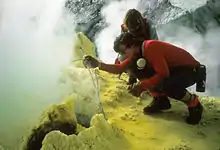
Mount Baker was built from stacks of lava and volcanic breccia prior to the end of the last glacial period, which ended about 15,000 years ago. Two craters are on the mountain. Ice-filled Carmelo Crater is under the summit ice dome.[4] This crater is the source for the last cone-building eruptions[33][34]
The highest point of Mount Baker, Grant Peak, is on the exposed southeast rim of Carmelo Crater, which is a small pile of andesitic scoria lying on top of a stack of lava flows just below. Carmelo Crater is deeply dissected on its south side by the younger Sherman Crater. This crater is south of the summit, and its ice-covered floor is 1,000 ft (300 m) below the summit ice dome. This crater is the site of all Holocene eruptive activity.[27] Hundreds of fumaroles vent gases, primarily H
2O, CO
2, and H
2S.[29][35]
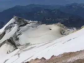
Lava flows from the summit vent erupted between 30,000 and 10,000 years ago, and during the final stages of edifice construction, blocky pyroclastic flows entered the volcano's southeastern drainages.[34] An eruption from Sherman Crater 6,600 years ago erupted a blanket of ash that extended more than 40 mi (64 km) to the east.[36] Today, sulfurous gases reach the surface via two fumarole pathways: Dorr Fumarole, northeast of the summit, and Sherman Crater, south of the summit. Both are sites of hydrothermal alteration, converting lavas to weak, white-to-yellow clays; sulfur is a common mineral around these fumaroles. At Sherman Crater, collapses of this weakened rock generated lahars in the 1840s.[27][37]
Mazama Park eruptive period: 6,600 years ago
Around 6,600 years ago, a series of discrete events culminated in the largest tephra-producing eruption in postglacial time at Mount Baker. This is the last episode of undoubted magmatic activity preserved in the geologic record.[4] First, the largest collapse in the history of the volcano occurred from the Roman Wall and transformed into a lahar that was over 300 feet (91 m) deep in the upper reaches of the Middle Fork of the Nooksack River. It was at least 25 ft (7.6 m) deep 30 mi (48 km) downstream from the volcano.[27] At that time, the Nooksack River is believed to have drained north into the Fraser River; this lahar is unlikely to have reached Bellingham Bay. Next, a small hydrovolcanic eruption occurred at Sherman Crater, triggering a second collapse of the flank just east of the Roman Wall. That collapse also became a lahar that mainly followed the course of the first lahar for at least 20 mi (32 km), and also spilled into tributaries of the Baker River. Finally, an eruption cloud deposited ash as far as 40 mi (64 km) downwind to the northeast and east.[36]
Historical activity
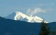
Several eruptions occurred from Sherman Crater during the 19th century;[38] they were witnessed from the Bellingham area.[39] A possible eruption was seen in June 1792 during the Spanish expedition of Dionisio Alcalá Galiano and Cayetano Valdés. Their report read, in part:
During the night [while anchored in Bellingham Bay] we constantly saw light to the south and east of the mountain of Carmelo [Baker] and even at times some bursts of flame, signs which left no doubt that there are volcanoes with strong eruptions in those mountains.[40]
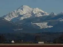
In 1843, explorers reported a widespread layer of newly fallen rock fragments "like a snowfall" and that the forest was "on fire for miles around". These fires were unlikely to have been caused by ashfall, however, as charred material is not found with deposits of this fine-grained volcanic ash, which was almost certainly cooled in the atmosphere before falling. Rivers south of the volcano were reportedly clogged with ash, and Native Americans reported that many salmon perished. Reports of flooding on the Skagit River from the eruption are, however, probably greatly exaggerated.[41] A short time later, two collapses of the east side of Sherman Crater produced two lahars, the first and larger of which flowed into the natural Baker Lake, increasing its level by at least 10 feet (3.0 m). The location of the 19th-century lake is now covered by waters of the modern dam-impounded Baker Lake. Similar but lower-level hydrovolcanic activity at Sherman Crater continued intermittently for several decades afterward.[32][39] On 26 November 1860, passengers who were traveling by steamer from New Westminster to Victoria reported that Mount Baker was "puffing out large volumes of smoke, which upon breaking, rolled down the snow-covered sides of the mountain, forming a pleasing effect of light and shade."[42] In 1891, about 15 km3 (3.6 cu mi) of rock fell producing a lahar that traveled more than 6 mi (9.7 km) and covered 1 sq mi (2.6 km2).[43]
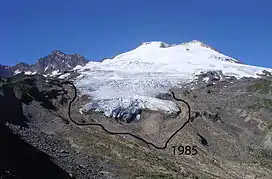
Activity in the 20th century decreased from the 19th century. Numerous small debris avalanches fell from Sherman Peak and descended the Boulder Glacier; a large one occurred on July 27, 2007.[44][45]
In early March 1975, a dramatic increase in fumarolic activity and snow melt in the Sherman Crater area raised concern that an eruption might be imminent.[26] Heat flow increased more than tenfold.[9][32] Additional monitoring equipment was installed and several geophysical surveys were conducted to try to detect the movement of magma.[26] The increased thermal activity prompted public officials and Puget Power to temporarily close public access to the popular Baker Lake recreation area and to lower the reservoir's water level by 33 feet (10 m). If those actions had not been taken, significant avalanches of debris from the Sherman Crater area could have swept directly into the reservoir, triggering a disastrous wave that could have caused human fatalities and damage to the reservoir.[39][46] Other than the increased heat flow, few anomalies were recorded during the geophysical surveys, nor were any other precursory activities observed that would indicate that magma was moving up into the volcano.[26] Several small lahars formed from material ejected onto the surrounding glaciers and acidic water was discharged into Baker Lake for many months.[9][32]
Activity gradually declined over the next two years, but stabilized at a higher level than before 1975.[9][32] The increased level of fumarolic activity has continued at Mount Baker since 1975, but no other changes suggest that magma movement is involved.[26]
Current research at Mount Baker
A considerable amount of research has been done at Mount Baker over the past decade, and it is now among the most-studied of the Cascade volcanoes. Recent and ongoing projects include gravimetric and GPS-based geodetic monitoring, fumarole gas sampling, tephra distribution mapping, new interpretations of the Schriebers Meadow lava flow, and hazards analyses. Mapping of Carmelo and Sherman craters, and interpretations of the eruptive history, continue, as well. The Mount Baker Volcano Research Center[29] maintains an online archive of abstracts of this work, and an extensive references list, as well as photos.
Glaciers and hydrology
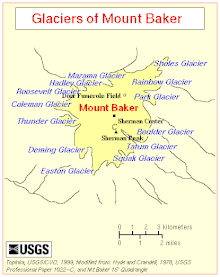
Eleven named glaciers descend from Mount Baker. Two additional glaciers (Hadley Glacier and Sholes Glacier) descend from lower slopes detached from the main glacial mass. The Coleman Glacier is the largest; it has a surface area of 1,285 acres (5.2 km2).[47] The other large glaciers—which have areas greater than 625 acres (2.5 km2)—are Roosevelt Glacier, Mazama Glacier, Park Glacier, Boulder Glacier, Easton Glacier, and Deming Glacier.[47][48] All retreated during the first half of the century, advanced from 1950–1975 and have been retreating with increasing rapidity since 1980.[49][50][51][52]
Mount Baker is drained on the north by streams that flow into the North Fork Nooksack River, on the west by the Middle Fork Nooksack River, and on the southeast and east by tributaries of the Baker River.[53] Lake Shannon and Baker Lake are the largest nearby bodies of water, formed by two dams on the Baker River.
U.S. Navy
Two ammunition ships of the United States Navy (traditionally named for volcanoes) have been named after the mountain. The first was USS Mount Baker (AE-4), which was commissioned from 1941 to 1947 and from 1951 to 1969.[54] In 1972, the Navy commissioned USS Mount Baker (AE-34). She was decommissioned in 1996 and placed in service with the Military Sealift Command as USNS Mount Baker (T-AE-34).[55] She was scrapped in 2012.
See also
References
- "Mount Baker, Washington". Peakbagger.com. Retrieved 2009-03-01.
- "Mount Baker". Geographic Names Information System. United States Geological Survey. Retrieved 2009-03-01.
- Hildreth, Wes (2007). Quaternary Magmatism in the Cascades — Geologic Perspectives. U.S. Geological Survey Professional Paper 1744. Reston, Virginia: United States Geological Survey. p. 9. ISBN 978-1-4113-1945-5.
- Hildreth, W.; Fierstein, J.; Lanphere, M. (2003-06-01). "Eruptive history and geochronology of the Mount Baker volcanic field, Washington". Geol. Soc. Am. Bull. 115 (6): 729–764. Bibcode:2003GSAB..115..729H. doi:10.1130/0016-7606(2003)115<0729:EHAGOT>2.0.CO;2. ISSN 0016-7606.
- Wood, Charles A.; Kienle, Jűrgen (1990). Volcanoes of North America. Cambridge University Press. pp. 155–156. ISBN 0-521-43811-X. OCLC 27910629.
- "Baker". Global Volcanism Program. Smithsonian Institution. Retrieved 2020-09-25.
- Oakley, Janet (2005-11-14). "Coleman Party reaches the summit of Mount Baker on August 17, 1868". The Online Encyclopedia of Washington State History. HistoryLink.org. Retrieved 2008-05-09.
- Coleman, Edmund T. (November 1869). "The First Ascent of Mount Baker". Harper's New Monthly Magazine. 39. Archived from the original on 2011-07-19. Retrieved 2008-05-09.
- Scott, Kevin M.; Hildreth, Wes; Gardner, Cynthia A. (2005-05-25). Mount Baker-Living with an Active Volcano: U.S. Geological Survey Fact Sheet 059-00. United States Geological Survey.
- Harris, Stephen L. (2005). Fire Mountains of the West: The Cascade and Mono Lake Volcanoes (3rd ed.). Mountain Press. p. 347. ISBN 0-87842-511-X.
- Topinka, Lyn (2008-04-15). "Mount Baker". United States Geological Survey. Retrieved 2008-05-08.
- "NOAA: Mt. Baker snowfall record sticks". USA Today. August 1, 1999. Archived from the original on May 25, 2010.
- Smoot, Jeff (2000). "The 100 Highest Mountains in Washington". Cascade Alpine Guide. Archived from the original on 2008-05-11. Retrieved 2008-05-19.
- "A Brief History of Mt. Baker". Mt. Baker-Snoqualmie National Forest — Climbing Mt. Baker. United States Forest Service. 2007-10-26. Retrieved 2008-05-11.
- Meany, Edmond Stephen (1907). "Chapter VI: Proceed up the Straits — Anchor under New Dungeness — Remarks on the Coast of New Albion — Arrive in Port Discovery — Transactions there — Boat Excursion — Quit Port Discovery — Astronomical and Nautical Observations". Vancouver's discovery of Puget Sound: Portraits and biographies of the men honored in the naming of geographic features of northwestern America. pp. 81–82.
- "Mt. Baker Highway — A Driving Guide to Washington State Highway 542" (PDF). Bellingham Whatcom County Tourism. 2005-07-25. Archived from the original (PDF) on 2011-04-28. Retrieved 2008-12-09.
- "The Mt. Baker Foothills Chain of Trails Concept Plan" (PDF). Mt. Baker Foothills Economic Development Association, Whatcom Council of Governments, Port of Bellingham, Whatcom County Parks and Recreation Department. December 2004. Archived from the original (PDF) on 2008-12-19. Retrieved 2008-12-09.
- "Whatcom Watch". February 1999.
- Mcdougall, Connie (1999-02-05). "On The Road To Mount Baker — Meander Through A Mushroom Farm, Ride An Old Railway Or Browse A Shop That Has It All On Whatcom County's Back Roads". The Seattle Times. Retrieved 2008-12-09.
- Beckey, Fred (August 1995). Cascade Alpine Guide: Climbing and High Routes: Rainy Pass to Fraser River. Mountaineers Books. ISBN 978-0-89886-423-6.
- Manuel Quimper (1790). "Map of the "Northwest Coast of North America — Strait of Juan de Fuca" which includes Mount Baker and the Cascade Range".
- "Early Impressions: Euro-American Explorations and Surveys". National Park Service. Retrieved 2012-05-04.
- Majors, H.M., ed. (1978). Mount Baker: A Chronicle of Its Historic Eruptions and First Ascent. Seattle: Northwest Press.
- Selters, Andy (2004). Ways to the Sky. Golden, Colorado: The American Alpine Club Press. p. 156. ISBN 0-930410-83-1.
- Tabor, Rowland W. (1999). Geology of the North Cascades: A Mountain Mosaic. The Mountaineers Books. p. 40. ISBN 0-89886-623-5. OCLC 40559713.
- Gardner, C.A.; Scott, K.M.; Miller, C.D.; Myers, B.; Hildreth, W.; Pringle, P.T. (1995). Potential Volcanic Hazards from Future Activity of Mount Baker, Washington: U.S. Geological Survey Open-File Report 95-498. United States Geological Survey.
- Scott, K.M; Tucker, D.S.; McGeehin, J.P. (2003). "Holocene history of Mount Baker volcano, North Cascades (abs)". XVI INQUA Congress Program with Abstracts: 162.
- Scott, K.M; D.S., Tucker (2006). "Eruptive Chronology of Mount Baker Revealed by Lacustrine Facies of Glacial Lake Baker (abs)". GSA Abstracts with Programs. 38 (5). Retrieved 2009-03-31.
- "Mount Baker Volcano Research Center". Retrieved 2009-03-31.
- Tucker, D.S.; Hildreth, W.; Ullrich, T.; Friedman, R. (2007). "Geology and complex collapse mechanisms of the 3.72 Ma Hannegan caldera, North Cascades, Washington, USA". Geol. Soc. Am. Bull. 119 (3/4): 329–342. Bibcode:2007GSAB..119..329T. doi:10.1130/B25904.1.
- Tucker, D.S. (2006). "Geologic map of the Pliocene Hannegan caldera, North Cascades, Washington (accompanying text)" (PDF). Digital map and Chart Series. Geological Society of America. p. 3. doi:10.1130/2006.DMCH003. Retrieved 2009-03-31.
-
 This article incorporates public domain material from the United States Geological Survey document: Topinka, Lyn. "Mount Baker, Washington, Brief Eruptive History". Retrieved 2008-05-11.
 - Scott, K.M.; Tucker, D.S.; McGeehin, J.P. (2003). "Island of Fire in a Sea of Ice — The Growth of Mount Baker volcano and the Fraser Glaciation in the North Cascades". XVI INQUA Congress Program with Abstracts: 51. Retrieved 2009-03-31.
- Tucker, D.S.; Scott, K.M. (2004). "Boulder Creek assemblage, Mount Baker, Washington: a record of the latest cone building eruptions". GSA Abstracts with Programs. 36 (4). Retrieved 2009-03-31.
- Werner, C.; Evans, W.C.; McGee, K.A.; Doukas, M.P.; Tucker, D.S.; Bergfeld, D.; Poland, M.P.; Crider, J.G. (2007). "Quiescent degassing of Mount Baker, Washington". GSA Abstracts with Programs. 39 (4): 65. Retrieved 2009-03-31.
- Tucker, D.S.; Scott, K.M.; Foit, F.F.; Mierendorf, R.R. (2007). "Age, distribution and composition of Holocene tephras from Mount Baker, Cascade arc, Washington, USA". Geological Society of America Abstracts with Programs. 39 (4): 66. Retrieved 2009-03-31.
- Warren, S.N.; Watters, R.J.; Tucker, D.S. (2006). "Future Edifice Collapse as a Result of Active Hydrothermal Alteration and Geologic Structure at Mt. Baker, Washington". Eos Trans. AGU. 87 (52): Fall Meet. Suppl., Abstract V53A–1746. Bibcode:2006EOSTr..87...53Z. doi:10.1029/2006EO050009. Retrieved 2009-03-31.
- Tucker, D.S; Scott, K.M.; Lewis, D. R. (2007). "Field guide to Mount Baker volcanic deposits in the Baker River valley: Nineteenth Century lahars, tephras, debris avalanches, and early Holocene subaqueous lava". In Stelling; Tucker (eds.). Floods, Faults and Fire: Geological Fieldtrips in Washington State and Southwest British Columbia. Geol. Soc. Amer. Field Guide. 9. Boulder, Colo. p. 83. doi:10.1130/2007.fld009(04). ISBN 978-0-8137-0009-0.
- Scott, K.M.; Tucker, D.S. (2003). "The Sherman Crater eruptive period at Mount Baker, North Cascades, 1843 To present: implications for reservoirs at the base of the volcano". GSA Abstracts with Programs. 35 (6). Retrieved 2009-03-31.
- Kendrick, John (1990). The Voyage of Sutil and Mexicana, 1792: The last Spanish exploration of the Northwest Coast of America. Spokane, Washington: The Arthur H. Clark Company. p. 108. ISBN 0-87062-203-X.
- Scott, K.M.; Tucker, D.S. (2004). "Natural dams and floods of legend at Mount Baker volcano-evidence from the stratigraphic record of volcanic activity during the Sherman Crater eruptive period (AD 1843 to present)". GSA Abstracts with Programs. 36 (5): 377. Retrieved 2009-03-31.
- Begg, Alexander. British Columbia: From the Earliest Times to the Present.
- Lewis, D.R.; Scott, K.M.; Tucker, D.S. (2007). "Debris avalanches in Rainbow Creek at Mount Baker, Washington — dating and matrix analysis". Geological Society of America Abstracts with Programs. 39 (4): 66.retrieved 2009-03-31
- "Boulder Debris Avalanche". Mount Baker Volcano Research Center. Retrieved 2009-03-31.
- Frank, D.; Post, A.; Friedman, J.D. (1975). "Recurrent geothermally induced debris avalanches on Boulder Glacier, Mount Baker, Washington". Journal of Research, US Geological Survey. 3 (1): 77–87.
- Brantley, Steven R. (1999-01-04). "Volcanoes of the United States, Online Version 1.1". USGS General Interest Publications. United States Geological Survey. Retrieved 2008-05-11.
- Post, A.; Richardson, D.; Tangborn, W.V.; Rosselot, F.L. (1971). "Inventory of glaciers in the North Cascades, Washington". USGS Prof. Paper. 705-A: A1–A26.
- Topinka, Lyn (2002-07-09). "Mount Baker Glaciers and Glaciation". United States Geological Survey. Retrieved 2008-05-09.
- Fountain, A.G.; Jackson, K.; Basagic, H.J.; Sitts, D. (2007). "A century of glacier change on Mount Baker, Washington". Geological Society of America Abstracts with Programs. 39 (4): 67. Retrieved 2009-03-31.
- Pelto, Mauri S. "North Cascade Glacier Climate Project". Archived from the original on 2013-05-30. Retrieved 2008-05-08.
- Pelto, M.; Hedlund, C. (2001). "Terminus behavior and response time of North Cascade glaciers, Washington, U.S.A". Journal of Glaciology. 47 (158): 496–506. Bibcode:2001JGlac..47..497P. doi:10.3189/172756501781832098.
- Beckey, Fred (1995). Cascade Alpine Guide: Climbing and High Routes: Rainy Pass to Fraser River (2nd ed.). Mountaineers Books. ISBN 0-89886-423-2. OCLC 14692076.
- Hyde, Jack H.; Crandell, Dwight Raymond (1978). "PostGlacial Volcanic Deposits at Mount Baker, Washington, and Potential Hazards from Future Eruptions". USGS Prof. Paper. 1022-C: C1.
- "Mount Baker". Dictionary of American Naval Fighting Ships. Department of the Navy — Naval Historical Center. Retrieved 2008-05-19.
- "MSC Ship Inventory — USNS Mount Baker". Military Sealift Command — Ship Inventory. Department of the Navy — Military Sealift Command. 2002-03-26. Retrieved 2008-05-19.
External links
- Mount Baker Volcano Research Center
- CVO Menu — Mt. Baker
- Terminus behavior of Mount Baker Glaciers
- Mount Baker Scenic Byway (PDF)
 Mount Baker travel guide from Wikivoyage
