List of Cultural Properties of Japan - historical materials (Kumamoto)
This list is of the Cultural Properties of Japan designated in the category of historical materials (歴史資料, rekishi shiryō) for the Prefecture of Kumamoto.[1]
National Cultural Properties
As of 1 February 2015, one Important Cultural Property has been designated, being of national significance.[2][3]
| Property | Date | Municipality | Ownership | Comments | Image | Coordinates | Ref. |
|---|---|---|---|---|---|---|---|
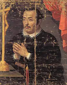
| Materials relating to Amakusa Shirō Tokisada 天草四郎時貞関係資料 Amakusa Shirō Tokisada kankei shiryō | early Edo period | Amakusa | Amakusa Christian Museum | 4 items, including a banner (pictured) used in the Shimabara Rebellion | .jpg.webp) | 32°27′36″N 130°11′03″E | |
Prefectural Cultural Properties
Properties designated at a prefectural level include:
| Property | Date | Municipality | Ownership | Comments | Image | Coordinates | Ref. |
|---|---|---|---|---|---|---|---|
| Ryōnai Meishō Zukan 領内名勝図巻 ryōnai meishō zukan | 1793 | Kumamoto | Eisei Bunko (kept at Kumamoto Prefectural Museum of Art) | 14 scrolls, depicting the domain's meisho; 396.7 metres (1,302 ft) by 59.2 centimetres (23.3 in) | 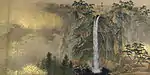 | 32°48′27″N 130°42′02″E | |
Municipal Cultural Properties
Properties designated at a municipal level include:
| Property | Date | Municipality | Ownership | Comments | Image | Coordinates | Ref. |
|---|---|---|---|---|---|---|---|
| Rosary and Jar ロザリオと壺 rozario to tsubo | Edo period | Amakusa | Amakusa Christian Museum | discovered during construction work by the coast in 1965, the seventeenth-century Chinese porcelain jar had inside it a necklace made from antlers, below which was a cross and a miniature image of Mary | 32°27′36″N 130°11′03″E | ||
| Official Bulletin Board Prohibiting Assembly 徒党禁止高札 totō kinshi kōsatsu | 1770 | Amakusa | Amakusa Christian Museum | the notice prohibits farmers from assembling and promises rewards for informers | 32°27′36″N 130°11′03″E | ||
| Oato Jizō Records, Nishinomiya Records, Ebisu Festival Records 尾跡地蔵講帳・西之宮講帳・恵美須祭礼帳 Oato Jizō kōchō・Nishinomiya kōchō・Ebisu saireichō | 1810-1955 | Kumamoto | Oato Community Centre (尾跡公民館) | 32°50′08″N 130°35′22″E | |||
| Documents from Kawachimachi Town Hall 河内町役場文書 Kawachimachi yakuba monsho | 1764 to Shōwa period | Kumamoto | 32°49′50″N 130°35′17″E | ||||
| Tsunami Memorial Tō 津波供養塔 tsunami kuyō tō | 1793 | Kumamoto | hōkyōintō erected in April 1793 after the tsunami of 1 April 1792 that resulted from a landslide on Mount Unzen | 32°49′50″N 130°35′17″E | |||
| Tsunami Memorial Stele 津波供養碑 tsunami kuyō hi | 1795 | Kumamoto | 32°49′50″N 130°35′17″E | ||||
| Tsunami Memorial Stele 津波供養碑 (蓮光寺) tsunami kuyō hi (Renkōji) | Kumamoto | Renkō-ji (蓮光寺) | commemorates 765 people from four villages who died in the tsunami | 32°49′53″N 130°35′19″E | |||
| Tsunami Memorial Inscription 津波供養碑 tsunami kuyō hi | Kumamoto | inscribed boulder commemorating the 1792 tsunami | 32°49′50″N 130°35′17″E | ||||
| Kumamoto Castle Exit and Entry Permit 熊本城出入鑑札附延享二年覚書 Kumamoto-jō shutsunyū kansatsu tsuketari Enkyō ninen oboegaki | Kumamoto | Kumamoto Castle | designation includes a note dated Enkyō 2 (1745) | 32°48′22″N 130°42′21″E | |||
See also
References
- "Pamphlet on Cultural Properties". Agency for Cultural Affairs. Archived from the original on 26 October 2014. Retrieved 5 February 2015.
- 国宝・重要文化財 [Number of National Treasures and Important Cultural Properties by Prefecture] (in Japanese). Agency for Cultural Affairs. 1 February 2015. Archived from the original on 30 June 2011. Retrieved 5 February 2015.
- "Database of National Cultural Properties: 国宝・重要文化財(美術品)(歴史資料 熊本県)" (in Japanese). Agency for Cultural Affairs. Archived from the original on 4 December 2015. Retrieved 5 February 2015.
This article is issued from Wikipedia. The text is licensed under Creative Commons - Attribution - Sharealike. Additional terms may apply for the media files.