Amakusa, Kumamoto
Amakusa (天草市, Amakusa-shi) is a city located in Kumamoto Prefecture, Japan.
Amakusa
天草市 | |||||||||||||
|---|---|---|---|---|---|---|---|---|---|---|---|---|---|
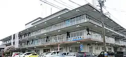 Amakusa City hall | |||||||||||||
 Flag  Emblem | |||||||||||||
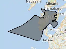
Location of Amakusa in Kumamoto Prefecture | |||||||||||||
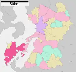 | |||||||||||||
 Amakusa Location in Japan | |||||||||||||
| Coordinates: 32°28′N 130°12′E | |||||||||||||
| Country | Japan | ||||||||||||
| Region | Kyushu | ||||||||||||
| Prefecture | Kumamoto Prefecture | ||||||||||||
| Government | |||||||||||||
| • Mayor | Kunihiko Kaneko(agent) | ||||||||||||
| Area | |||||||||||||
| • Total | 683.17 km2 (263.77 sq mi) | ||||||||||||
| Population (March 31, 2017) | |||||||||||||
| • Total | 83,082 | ||||||||||||
| • Density | 120/km2 (310/sq mi) | ||||||||||||
| Time zone | UTC+09:00 (JST) | ||||||||||||
| City hall address | 8-1 Higashihamamachi, Amakusa-shi, Kumamoto-ken 863-0014 | ||||||||||||
| Website | www | ||||||||||||
| |||||||||||||
| Amakusa | |||||
|---|---|---|---|---|---|
| Japanese name | |||||
| Kanji | 天草市 | ||||
| Hiragana | あまくさし | ||||
| Katakana | アマクサシ | ||||
| |||||
Amakusa City covers parts of two main islands, and six smaller islets. They are referred to as Kamishima 上島 (天草諸島) and Shimoshima 下島 (天草諸島) (Upper Island and Lower Island). It has the distinction of being the fastest depopulating city in Japan since the last census. (2005)
The modern city of Amakusa was established on March 27, 2006, from the merger between the old cities of Hondo and Ushibuka, and the towns of Amakusa (former), Ariake, Goshoura, Itsuwa, Kawaura, Kuratake, Shinwa and Sumoto (all from Amakusa District).
As of March 31, 2017, the city has an estimated population of 83,082[1] and a population density of 120 persons per km2. The total area is 683.17 km (424.50 mi).
Amakusa Airlines is headquartered in Amakusa.[2]
Climate
Amakusa has a humid subtropical climate (Köppen climate classification Cfa) with hot summers and cool winters. Precipitation is significant throughout the year, and is heaviest from May to August.
| Climate data for Ushibuka/Amakusa, Kumamoto | |||||||||||||
|---|---|---|---|---|---|---|---|---|---|---|---|---|---|
| Month | Jan | Feb | Mar | Apr | May | Jun | Jul | Aug | Sep | Oct | Nov | Dec | Year |
| Average high °C (°F) | 10.9 (51.6) |
11.7 (53.1) |
15.0 (59.0) |
19.7 (67.5) |
23.2 (73.8) |
25.8 (78.4) |
29.7 (85.5) |
31.3 (88.3) |
28.5 (83.3) |
24.0 (75.2) |
18.8 (65.8) |
13.5 (56.3) |
21.0 (69.8) |
| Daily mean °C (°F) | 7.8 (46.0) |
8.4 (47.1) |
11.3 (52.3) |
15.9 (60.6) |
19.5 (67.1) |
22.4 (72.3) |
26.4 (79.5) |
27.6 (81.7) |
24.8 (76.6) |
20.1 (68.2) |
15.2 (59.4) |
10.2 (50.4) |
17.5 (63.4) |
| Average low °C (°F) | 4.8 (40.6) |
5.3 (41.5) |
7.8 (46.0) |
12.4 (54.3) |
16.2 (61.2) |
19.7 (67.5) |
23.9 (75.0) |
24.7 (76.5) |
22.0 (71.6) |
17.0 (62.6) |
12.0 (53.6) |
7.2 (45.0) |
14.4 (58.0) |
| Average precipitation mm (inches) | 97.9 (3.85) |
93.7 (3.69) |
132.7 (5.22) |
171.0 (6.73) |
201.1 (7.92) |
350.0 (13.78) |
288.4 (11.35) |
200.6 (7.90) |
181.0 (7.13) |
90.7 (3.57) |
95.5 (3.76) |
86.0 (3.39) |
1,988.6 (78.29) |
| Average snowfall cm (inches) | 5 (2.0) |
3 (1.2) |
0 (0) |
0 (0) |
0 (0) |
0 (0) |
0 (0) |
0 (0) |
0 (0) |
0 (0) |
0 (0) |
2 (0.8) |
10 (4) |
| Average relative humidity (%) | 65 | 65 | 66 | 72 | 75 | 82 | 83 | 78 | 75 | 67 | 66 | 66 | 72 |
| Mean monthly sunshine hours | 105.2 | 109.8 | 158.9 | 164.7 | 180.9 | 141.5 | 196.8 | 237.2 | 187.0 | 192.7 | 152.3 | 117.2 | 1,944.2 |
| Source: NOAA (1961-1990)[3] | |||||||||||||
Sightseeing Spots
- Alegria Gardens
- Amakusa Christian Museum
- Amakusa Dolphin Marine Land
- Ōe Catholic Church
- Sakitsu Catholic Church
- Shimoda Onsen hot springs
 Amakusa Christian Museum
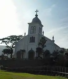 Ōe Catholic Church
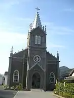 Sakitsu Catholic Church
 Shimoda Onsen hot springs
Notable people
- Sunao Sonoda, statesman
- Hiroyuki Sonoda, statesman
- Kundō Koyama, film writer
- Michiko Ishimure, writer
- Tochihikari Masayuki, sumo wrestler
- Yoshiki Tanaka, novelist
Sister Cities
 Encinitas, California, United States[4]
References
- "Official website of Amakusa City" (in Japanese). Japan: Amakusa City. Retrieved 30 April 2017.
- "AMX会社概要 Archived 2009-08-04 at the Wayback Machine." Amakusa Airlines. Retrieved on May 20, 2009.
- "Ushibuka Climate Normals 1961-1990". National Oceanic and Atmospheric Administration. Retrieved January 6, 2013.
- "Archived copy". Archived from the original on 2012-07-14. Retrieved 2012-08-14.CS1 maint: archived copy as title (link)
External links
| Wikivoyage has a travel guide for Amakusa. |
 Media related to Amakusa, Kumamoto at Wikimedia Commons
- Amakusa City official website (in Japanese)
 Geographic data related to Amakusa, Kumamoto at OpenStreetMap
| Kumamoto |
| |||
|---|---|---|---|---|
| Cities | ||||
| Districts | ||||
| Authority control |
|---|