List of National Monuments in County Limerick
The Irish state has officially approved the following List of National Monuments in County Limerick. In the Republic of Ireland, a structure or site may be deemed to be a "National Monument", and therefore worthy of state protection, if it is of national importance. If the land adjoining the monument is essential to protect it, this land may also be protected.
National Monuments
| NM# | Monument name | Description | Image | Townland | Location |
|---|---|---|---|---|---|
| 212 | Kilmallock Abbey | Friary (Dominican) | 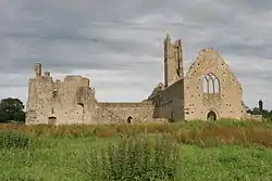 | Abbeyfarm | 52°24′09″N 8°34′30″W |
| 622 | Desmond Castle | Castle | .jpg.webp) | Adare | 52°34′10″N 8°46′56″W |
| 201 | Askeaton Castle | Castle | 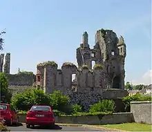 | Askeaton | 52°36′00″N 8°58′26″W |
| 625 | Ballylanders fort | Ringfort | Ballylanders | 52°22′51″N 8°21′09″W | |
| 247 | Lough Gur | Enclosure | 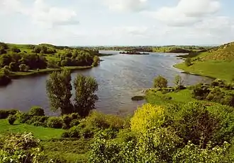 | Bruff | 52°30′51″N 8°32′31″W |
| 247 | Lough Gur Tomb | Megalithic Tomb unclassified |  | Lough Gur | 52°30′31″N 8°31′55″W |
| 85 | Mungret Churches | Three Churches | 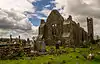 | Baunacloka, Dromdarrig | 52°38′04″N 8°40′32″W |
| 194 | Hospital Church | Church (Knights Hospitallers) | Barrysfarm | 52°28′34″N 8°25′57″W | |
| 83 | Dísert Óengusa | Early Medieval Hermitage | 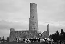 | Carrigeen (Croom) | 52°31′15″N 8°44′41″W |
| 636, 582 | Desmond Hall and Castle | Medieval Castle Complex | %252C_Newcastle_West%252C_Limerick_-_geograph.org.uk_-_1392672.jpg.webp) | Newcastlewest | 52°27′00″N 9°03′42″W |
| 84 | Clonkeen Church | Church | Clonkeen (Barrington) | 52°38′38″N 8°27′36″W | |
| 345 | Killeen Cowpark | Church | 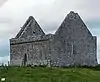 | Cowpark | 52°36′29″N 8°53′38″W |
| 663 | Cush Earthworks | Earthworks | Cush | 52°22′52″N 8°26′34″W | |
| 315 | Duntryleague passage tomb | Passage Tomb | .jpg.webp) | Deerpark (Duntryleague) | 52°24′23″N 8°19′21″W |
| 555 | Rathard | Ringfort | Garryheakin | 52°31′03″N 8°18′24″W | |
| 341 | Killulta Church | Church | 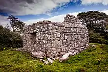 | Glennameade | 52°37′45″N 8°50′10″W |
| 268 | Glenquin Castle | Castle | 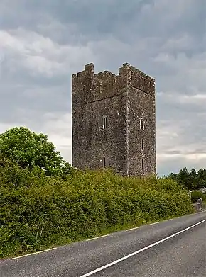 | Killeedy | 52°23′02″N 9°06′25″W |
| 247 | Lough Gur Stone Circle | Stone Circle (potential) |  | Lough Gur | 52°30′55″N 8°32′29″W |
| 247 | Lough Gur Standing Stone | Standing Stone | Lough Gur | ||
| 247 | Grange stone circle | Embanked Stone Circle | 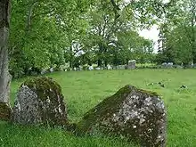 | Grange | 52°30′51″N 8°32′30″W |
| 247 | The Spectacles | House sites & field system | Grange | 52°31′18″N 8°31′11″W | |
| 247 | Crock Island | Crannóg | Grange | 52°31′12″N 8°32′16″W | |
| 247 | Lough Gur Megalithic Structure | Megalithic Structure | Lough Gur | ||
| 680 | Kilmallock Medieval House | Medieval House | Abbeyfarm (Kilmallock) | 52°24′02″N 8°34′23″W | |
| 408 | Collegiate Church of SS Peter & Paul | Church | 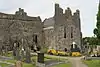 | Killmallock | 52°24′04″N 8°34′29″W |
| 173 | King John's Castle | Castle | _-_geograph.org.uk_-_1392873.jpg.webp) | Kilmallock | 52°24′05″N 8°34′36″W |
| 538 | Kilmihill Ringfort | Ringfort | Kilmihil (Ballingarry) | 52°27′38″N 8°51′17″W | |
| 247 | Lough Gur Cemetery | Cairn | Lough Gur | 52°30′39″N 8°31′39″W | |
| 247 | Lough Gur Ringfort | Ringfort | Lough Gur | ||
| 576 | De Valera's Cottage | House with historic associations | 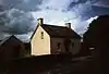 | Knockmore | 52°26′01″N 8°39′25″W |
| 86 | Killaliathan Church (Killagholehane church, Our Lady of the Snows) | Church | Lacka Lower | 52°19′54″N 8°58′38″W | |
| 366 | Kilrush Church | Church | %252C_Kilrush_Church_(1).jpg.webp) | Limerick | 52°39′39″N 8°39′19″W |
| 288 | King John's Castle | Castle | 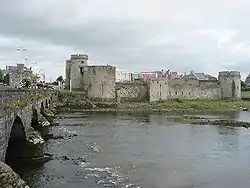 | Limerick | 52°40′11″N 8°37′32″W |
| 383 | Fanning's Castle | Castle | .jpg.webp) | Limerick (Creagh Lane) | 52°40′02″N 8°37′19″W |
| 247 | Lough Gur House | Prehistoric House Site | Lough Gur | ||
| 247 | Lough Gur Wedge Tomb | Wedge Tomb | Lough Gur | ||
| 247 | Knockadoon | Prehistoric Habitation | Lough Gur | ||
| 247 | Carraig Aille | Enclosure | Lough Gur | ||
| 247 | Lough Gur Cemetery Mound | Cemetery Mound | Lough Gur | ||
| 247 | Leagun | Standing Stone | Lough Gur | ||
| 185 | Askeaton Abbey | Friary (Franciscan) | 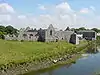 | Moig South | 52°36′14″N 8°58′31″W |
| 171 | Monasteranenagh Abbey | Abbey (Cistercian) | 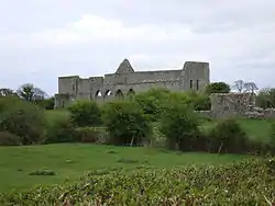 | Monaster South | 52°31′01″N 8°39′46″W |
| 459 | Ardagh Fort | Ringfort | Reerasta South | 52°29′37″N 9°04′05″W |
Sources
This article is issued from Wikipedia. The text is licensed under Creative Commons - Attribution - Sharealike. Additional terms may apply for the media files.