List of fracture zones
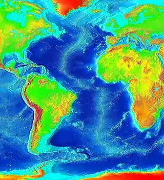
Fracture zones are common features in the geology of oceanic basins. Globally most fault zones are located on divergent plate boundaries on oceanic crust. This means that they are located around mid-ocean ridges and trend perpendicular to them. The term fracture zone is used almost exclusively for features on oceanic crust; similar structures on continental crust are instead termed transform or strike slip faults, a denomination active fracture zones also can have. Some fracture zones have been created by mid-ocean ridge segments that have been subducted and may not longer exist.
Pacific Ocean

Most fracture zones in the Pacific Ocean originate from large mid-ocean ridges (also called "rises") such as the East Pacific Rise, Chile Rise and Juan de Fuca Ridge. The plates that host the fractures are Nazca, Pacific, Antarctic, Juan de Fuca and Cocos among others. Fracture zones being subducted under Southern and Central America are generally southwest-northeast oriented reflecting the relative motion of Cocos, Nazca and the Antarctic Plates.
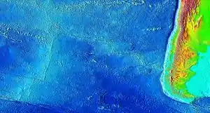
Chile Rise
The fracture zones of the Chile Rise trend in a west to east fashion with the most southern ones taking a slightly more southwest to northeast orientation. This non-perpendicular relation to Chile's coast reflects the oblique subduction of Nazca Plate under southern Chile. West of Chile rise the fracture zones are hosted in the Antarctic Plate. Some fracture zones such as Chile and Valdivia make up large sections of the Nazca-Antarctic Plate boundary.
| Name | Minimum length in km | Length of transform boundary in km | Position at Ridge |
|---|---|---|---|
| Chile | 2,250 (1,400) | 1,100 (680) | 35°32′24″S 104°37′3″W |
| Chiloé | 1,750 (1,090) | 50 (30) | 42°59′43″S 83°11′5″W |
| Darwin | 50 (30) | 45°54′29″S 76°25′31″W | |
| Desolación | 0 | ||
| Esmeralda | 0 | 49°06′47″S 80°12′33″W | |
| Guafo | 1,550 (960) | 280 (170) | 44°47′55″S 80°15′53″W |
| Guamblin | 1,300 (810) | 70 (40) | 45°44′7″S 77°27′32″W |
| Madre de Dios | 0 | ||
| Mocha | 450 (280) | 0 | 39°14′24″S 77°22′59″W |
| Taitao | 0 | ||
| Tres Montes | 0 | ||
| Valdivia | 2,100 (1,300) | 650 (400) | 41°23′25″S 87°23′36″W |
East Pacific Rise
| Name | Minimum length in km | Length as plate boundary in km | Coordinates |
|---|---|---|---|
| Easter | |||
| Mendaña | 0 | ||
| Nazca | 0 | 19°49′28″S 77°35′53″W | |
| Quiros | 0 |
Galapagos Rise
Atlantic Ocean
In the Atlantic Ocean most fracture zones originate from the Mid-Atlantic Ridge, which runs from north to south, and are therefore west to east oriented in general. There are about 300 fracture zones, with an average north-south separation of 55 kilometres (34 mi):[1] two for each degree of latitude. Physically it makes sense to group Atlantic fracture zones into three categories:[2]
- Small offset: length of transform fault less than 30 kilometres (19 mi)
- Medium offset: offset over 30 kilometers
- Large offset: offset several hundreds of kilometers
Mid-Atlantic Ridge (Northern Hemisphere)
Fracture zones involved in the early opening of the North Atlantic
| American side | African side |
|---|---|
| Hudson Fracture Zone | |
| Snorri Fracture Zone | |
| Cartwright Fracture Zone | |
| Julian Haab Fracture Zone | |
| Minna Fracture Zone | |
| Leif Fracture Zone | |
| Newfoundland Fracture Zone[8] | |
| Kelvin Fracture Zone[9] | Canary Fracture Zone[9] |
| Cape Fear Fracture Zone[9] | Cape Verde Fracture Zone[9] |
| Bahama Fracture Zone[9] | Guinea Fracture Zone[9] |
Mid-Atlantic Ridge (Southern Hemisphere)
| Name | Minimum length in km | Length of transform fault in km | Position at Ridge |
|---|---|---|---|
| Romanche[3] | 2445 | 950 | 0.49°S 20.49°W |
| Chain[3] | 1315 | 269 | 1.213°S 14.229°W |
| Ascension[3] | 1149 | 264 | 6.928°S 12.283°W |
| Bode Verde[3] | 3018 | 232 | 11.686°S 13.936°W |
| Cardno[3] | 1649 | 87 | 14.076°S 14.056°W |
| Tetyaev[3] | 810 | 122 | 16.271°S 13.719°W |
| Saint Helena[3] | 1184 | 19 | 16.617°S 14.344°W |
| Hotspur[3] | 1446 | 113 | 17.721°S 13.329°W |
| Martin Vaz[3] | 1324 | 26 | 18.594°S 12.633°W |
| Rio Grande[3] | 1774 | 156 | 29.081°S 13.067°W |
| Tristan Da Cunha[3] | 1014 | 26 | 38.388°S 16.796°W |
| Gough[3] | 1057 | 42 | 40.637°S 16.637°W |
| Conrad (to the west)[3] | 316 | 0 | 55.185°S 0.133°W |
| Bouvet (to the east)[3] | 198 | 0 | 55.185°S 0.133°W |
Indian Ocean
Southwest Indian Ridge
- Bouvet Fracture Zone
- Moshesh Fracture Zone
- Islas Orcadas Fracture Zone
- Shaka Fracture Zone
- Dutoit Fracture Zone
- Prince Edward Fracture Zone
- Discovery II Fracture Zone
- Indomed Fracture Zone
- Gallieni Fracture Zone
- Atlantis II Fracture Zone[10]
- Novara Fracture Zone[10]
- Melville Fracture Zone[10]
Carlsberg Ridge
Central Indian Ridge
- Mauritius
Lakshadweeo-Chagos Ridge
- Vishnu
Southern Ocean
- Endurance
- Eltanin
- Hero
- Quest
- Shackleton
- Vinogradov
References
- Gilman, Larry; Lerner, K. Lee. "Mid-Ocean-Ridges". Water Encyclopedia. Retrieved 2011-11-29.
- Müller, R. Dietmar; Roest, Walter R. (1992). "Fracture Zones in the North Atlantic from Combined Geosat and Seasat Data" (PDF). Journal of Geophysical Research. 97 (B3): 3337–50. Bibcode:1992JGR....97.3337M. doi:10.1029/91JB02605. Archived from the original (PDF) on 2012-03-28. Retrieved 2011-11-30.
- Name from GEBCO gazetteer, position refined by means of etopo2 and sample data of GPlates
- Udintsev, G.B. (1996). "Equatorial Segment of the Mid-Atlantic Ridge". Unesco. Archived from the original on 2012-09-07. Retrieved 2011-12-05.
- Roest, W. R.; Collette, B. J. (1986). "The Fifteen Twenty Fracture Zone and the North American – South American plate boundary". Journal of the Geological Society. 143: 833–43. doi:10.1144/gsjgs.143.5.0833.
- Tucholke, Brian E.; Schouten, Hans (1988-03-01). "Kane Fracture Zone". Marine Geophysical Research. 10: 1–39. Bibcode:1988MarGR..10....1T. doi:10.1007/BF02424659.
- "Map with Jan Mayen, Greenland and Senja Fracture Zones". Ocean Drilling Project. Retrieved 2011-12-16.
- Auzende, J.M.; Olivet, J.L.; Bonnin, J. (1970). "Marge du Grand Bank et la fracture de Terre-Neuve". Compt. Rend. (in French). 271: 1063–66.
- Le Pichon, Xavier; Fox, Paul J. (1971-09-10). "Marginal Offsets, Fracture Zones, and the Early Opening of the North Atlantic". Journal of Geophysical Research. 76 (26): 6294–308. Bibcode:1971JGR....76.6294L. doi:10.1029/JB076i026p06294.
- Patriat, P., Sauter, D., Munschy, M., & Parson, L. (1997). A survey of the Southwest Indian Ridge axis between Atlantis II Fracture Zone and the Indian Ocean Triple Junction: Regional setting and large scale segmentation. Marine Geophysical Researches, 19(6), 457–80.
- Sources
