List of listed buildings in Abercorn, West Lothian
This is a list of listed buildings in the parish of Abercorn in West Lothian, Scotland.
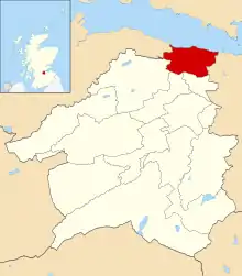
Abercorn parish shown within West Lothian
List
| Name | Location | Date Listed | Grid Ref. [note 1] | Geo-coordinates | Notes | LB Number [note 2] | Image |
|---|---|---|---|---|---|---|---|
| Philipstoun Station, Union Canal, Bridge 39 | 55°58′31″N 3°31′03″W | Category C(S) | 6430 | 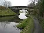 | |||
| Summer House I, Hopetoun Policies | 55°59′49″N 3°28′12″W | Category B | 618 |  | |||
| East Gate, Hopetoun Policies | 55°59′40″N 3°26′38″W | Category B | 624 | 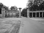 | |||
| Craigton House | 55°58′29″N 3°29′16″W | Category B | 6423 | 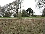 | |||
| Old East Gate, Hopetoun Policies | 55°59′32″N 3°26′37″W | Category B | 5649 | | |||
| Hopetoun House | 55°59′43″N 3°27′46″W | Category A | 613 | 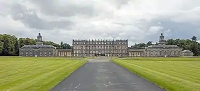 | |||
| Hopetoun Estate Buildings | 55°59′39″N 3°27′36″W | Category A | 614 | | |||
| Stoney Hill Gate (Obelisk Gate) | 55°59′29″N 3°27′14″W | Category B | 621 | | |||
| Duddingstone Icehouse | 55°59′12″N 3°26′24″W | Category C(S) | 627 | | |||
| Craigton, Sundial | 55°58′28″N 3°29′16″W | Category C(S) | 6424 | | |||
| Stone Couple, Union Canal, Bridge 36 | 55°58′24″N 3°29′40″W | Category C(S) | 6427 | | |||
| Obelisk Cottage | 55°59′31″N 3°27′11″W | Category B | 622 | | |||
| Society House, Hopetoun Policies | 55°59′45″N 3°26′55″W | Category B | 623 | | |||
| Woodend, Norwood | 55°58′51″N 3°27′45″W | Category C(S) | 628 | | |||
| Woodend, Hopetoun Estate Cottages (Nos 1-5) | 55°58′52″N 3°27′48″W | Category C(S) | 629 | | |||
| Cockmuir, Union Canal, Bridge 37 | 55°58′25″N 3°30′09″W | Category C(S) | 6428 | | |||
| Philipstoun House | 55°59′01″N 3°29′54″W | Category B | 6431 |  | |||
| Philipstoun House, Dovecote | 55°59′07″N 3°29′59″W | Category B | 6432 | | |||
| The Binns | 55°59′17″N 3°31′26″W | Category A | 632 |  | |||
| West Lodge, Hopetoun Policies | 55°59′35″N 3°28′47″W | Category B | 615 |  | |||
| Summer House II ("The Pulpit"), Hopetoun Policies | 55°59′33″N 3°27′56″W | Category B | 619 | | |||
| Duddingstone House | 55°59′00″N 3°26′28″W | Category B | 625 | | |||
| Duntarvie Castle | 55°58′22″N 3°27′32″W | Category A | 6422 | 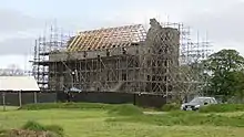 | |||
| Craigton, Union Canal, Bridge 35 | 55°58′22″N 3°29′25″W | Category B | 6426 | | |||
| Fawnspark, Union Canal, Bridge 38 | 55°58′27″N 3°30′31″W | Category C(S) | 6429 | 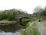 | |||
| Abercorn Kirk | 55°59′46″N 3°28′27″W | Category A | 612 | 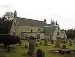 | |||
| Nethermill Bridge, Hopetoun Policies | 55°59′52″N 3°28′36″W | Category C(S) | 617 | | |||
| Midhope Castle | 55°59′32″N 3°29′16″W | Category A | 630 | 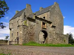 | |||
| Midhope Doocot | 55°59′29″N 3°29′12″W | Category B | 631 | 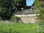 | |||
| Binns Tower, Binns Hill | 55°59′27″N 3°31′13″W | Category B | 633 | 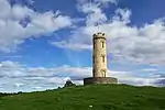 | |||
| Abercorn House, (Former Manse) Including North Courtyard Range And Walls, Walled Garden And Linked Outbuildings, Entrance Gatepiers And Boundary Walls | 55°59′41″N 3°28′29″W | Category C(S) | 50231 | 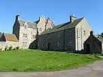 | |||
| Craigton, Gatepiers | 55°58′28″N 3°29′22″W | Category C(S) | 6425 | | |||
| Hopetoun Mausoleum, Hopetoun Policies | 55°59′43″N 3°28′23″W | Category B | 616 | | |||
| Duddingstone Steading | 55°59′00″N 3°26′33″W | Category B | 626 | | |||
| Abercorn School and Former School Master's House | 55°58′47″N 3°29′18″W | Category C(S) | 48419 | 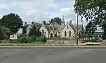 |
Key
The scheme for classifying buildings in Scotland is:
- Category A: "buildings of national or international importance, either architectural or historic; or fine, little-altered examples of some particular period, style or building type."[1]
- Category B: "buildings of regional or more than local importance; or major examples of some particular period, style or building type, which may have been altered."[1]
- Category C: "buildings of local importance; lesser examples of any period, style, or building type, as originally constructed or moderately altered; and simple traditional buildings which group well with other listed buildings."[1]
In March 2016 there were 47,288 listed buildings in Scotland. Of these, 8% were Category A, and 50% were Category B, with the remaining 42% being Category C.[2]
Notes
- Sometimes known as OSGB36, the grid reference (where provided) is based on the British national grid reference system used by the Ordnance Survey.
• "Guide to National Grid". Ordnance Survey. Retrieved 2007-12-12.
• "Get-a-map". Ordnance Survey. Retrieved 2007-12-17. - Historic Environment Scotland assign a unique alphanumeric identifier to each designated site in Scotland, for listed buildings this always begins with "LB", for example "LB12345".
References
- All entries, addresses and coordinates are based on data from Historic Scotland. This data falls under the Open Government Licence
- "What is Listing?". Historic Environment Scotland. Retrieved 29 May 2018.
- Scotland's Historic Environment Audit 2016 (PDF). Historic Environment Scotland and the Built Environment Forum Scotland. pp. 15–16. Retrieved 29 May 2018.
This article is issued from Wikipedia. The text is licensed under Creative Commons - Attribution - Sharealike. Additional terms may apply for the media files.