List of listed buildings in Mid Calder, West Lothian
This is a list of listed buildings in the parish of Mid Calder in West Lothian, Scotland.
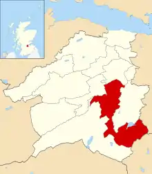
Mid Calder parish shown within West Lothian
List
| Name | Location | Date Listed | Grid Ref. [note 1] | Geo-coordinates | Notes | LB Number [note 2] | Image |
|---|---|---|---|---|---|---|---|
| 68 Main Street | 55°53′27″N 3°28′56″W | Category C(S) | 14146 |  | |||
| Calder House | 55°53′22″N 3°29′04″W | Category A | 14153 | 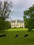 | |||
| Wester Causewayend Farmhouse And Steading | 55°49′58″N 3°27′55″W | Category B | 18980 | | |||
| Westfield House | 55°51′31″N 3°31′40″W | Category B | 18442 | | |||
| Alderston House, With Offices | 55°52′49″N 3°31′48″W | Category B | 18443 | | |||
| Murieston House, Easter Murieston | 55°51′57″N 3°30′24″W | Category B | 14134 | | |||
| Black Bull Inn 6-4A-4 Market Street | 55°53′33″N 3°28′52″W | Category C(S) | 14136 | 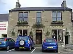 | |||
| 23-25 Bank Street | 55°53′34″N 3°28′49″W | Category C(S) | 14141 | | |||
| 41, 43, 47 Bank Street | 55°53′34″N 3°28′46″W | Category B | 14149 | | |||
| Torphichen Arms Hotel, Bank Street | 55°53′33″N 3°28′47″W | Category B | 14150 | 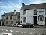 | |||
| Howden Bridge | 55°53′19″N 3°30′13″W | Category B | 14163 | 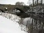 | |||
| Williamston Bridge | 55°52′31″N 3°29′42″W | Category C(S) | 14164 | | |||
| Bridge, Murieston House | 55°51′57″N 3°30′21″W | Category B | 18833 | | |||
| Alderston Park, Doocot | 55°52′50″N 3°31′46″W | Category B | 18444 | | |||
| Newpark House | 55°52′00″N 3°31′19″W | Category C(S) | 14143 | | |||
| Midcalder Village Mid Calder Parish Kirk (St. John's Church) Main Street | 55°53′24″N 3°28′57″W | Category A | 14144 | | |||
| Calder Steading | 55°53′16″N 3°29′19″W | Category B | 14154 | | |||
| Gateway, Calder Estate, West Calder Road | 55°53′20″N 3°28′54″W | Category A | 14155 | 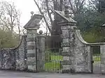 | |||
| Oak Cafe 11 Bank Street | 55°53′33″N 3°28′51″W | Category C(S) | 14138 | | |||
| Brewery House, 70 Main Street | 55°53′26″N 3°28′56″W | Category B | 14145 | | |||
| Livingston Bridge, River Almond | 55°53′05″N 3°32′21″W | Category B | 14161 | | |||
| Cairns Castle, Easter Cairns, By Harperrig Reservoir | 55°49′45″N 3°27′13″W | Category B | 47559 | | |||
| Skivo Farm (Skivo Kennels) | 55°51′26″N 3°30′51″W | Category C(S) | 14135 | | |||
| 37-39 Bank Street | 55°53′35″N 3°28′47″W | Category C(S) | 14142 | | |||
| 35 Bank Street | 55°53′35″N 3°28′48″W | Category C(S) | 14148 | | |||
| East Bridge, Linhouse Water, East Calder Road | 55°53′34″N 3°28′41″W | Category B | 14151 | | |||
| Howden House | 55°53′34″N 3°31′02″W | Category B | 14162 | | |||
| Bellsquarry, 30 Calder Road With Boundary Walls | 55°52′10″N 3°31′37″W | Category C(S) | 44584 | | |||
| 19-21-21A Bank Street | 55°53′34″N 3°28′49″W | Category C(S) | 19670 | | |||
| 2 Market Street | 55°53′33″N 3°28′51″W | Category C(S) | 14137 | | |||
| The Old Schoolhouse Causewayend Kirknewton | 55°50′03″N 3°27′30″W | Category B | 14158 | | |||
| House, Pumpherston Road | 55°53′36″N 3°28′40″W | Category B | 19671 | | |||
| 15 (Formerly 13-15) Bank Street | 55°53′33″N 3°28′50″W | Category C(S) | 14139 | | |||
| Clydesdale Bank 17 Bank Street | 55°53′33″N 3°28′50″W | Category C(S) | 14140 | | |||
| 29 Bank Street | 55°53′34″N 3°28′48″W | Category B | 14147 | | |||
| Linhouse Mansion | 55°51′03″N 3°29′57″W | Category A | 14156 |  | |||
| Doocot, Linhouse | 55°51′07″N 3°30′05″W | Category B | 14157 | | |||
| Stables, The Old Schoolhouse, Causewayend Kirknewton | 55°50′04″N 3°27′31″W | Category B | 14159 | | |||
| Brucefield Farmhouse And Steading | 55°51′59″N 3°32′07″W | Category B | 14160 | | |||
| Bankton House | 55°52′28″N 3°30′04″W | Category B | 19672 | | |||
| Wester Murieston, Murieston Castle | 55°51′19″N 3°31′08″W | Category B | 18441 | | |||
| Gate-Lodge And Gate-Way, Calder Estate, Bank Street | 55°53′32″N 3°28′50″W | Category C(S) | 14152 | |
Key
The scheme for classifying buildings in Scotland is:
- Category A: "buildings of national or international importance, either architectural or historic; or fine, little-altered examples of some particular period, style or building type."[1]
- Category B: "buildings of regional or more than local importance; or major examples of some particular period, style or building type, which may have been altered."[1]
- Category C: "buildings of local importance; lesser examples of any period, style, or building type, as originally constructed or moderately altered; and simple traditional buildings which group well with other listed buildings."[1]
In March 2016 there were 47,288 listed buildings in Scotland. Of these, 8% were Category A, and 50% were Category B, with the remaining 42% being Category C.[2]
Notes
- Sometimes known as OSGB36, the grid reference (where provided) is based on the British national grid reference system used by the Ordnance Survey.
• "Guide to National Grid". Ordnance Survey. Retrieved 2007-12-12.
• "Get-a-map". Ordnance Survey. Retrieved 2007-12-17. - Historic Environment Scotland assign a unique alphanumeric identifier to each designated site in Scotland, for listed buildings this always begins with "LB", for example "LB12345".
References
- All entries, addresses and coordinates are based on data from Historic Scotland. This data falls under the Open Government Licence
- "What is Listing?". Historic Environment Scotland. Retrieved 29 May 2018.
- Scotland's Historic Environment Audit 2016 (PDF). Historic Environment Scotland and the Built Environment Forum Scotland. pp. 15–16. Retrieved 29 May 2018.
This article is issued from Wikipedia. The text is licensed under Creative Commons - Attribution - Sharealike. Additional terms may apply for the media files.