List of places of worship in Adur
The district of Adur, one of seven local government districts in the English county of West Sussex, has 26 extant churches and other places of worship, and a further seven former churches that are no longer in religious use. The southern part of the district forms part of the Brighton/Worthing/Littlehampton conurbation, and almost all of the churches are in the towns and villages within this continuous built-up area. The rural northern part of the district has one ancient church that is still in use, and another former chapel that served a now deserted medieval village. Many Christian denominations are represented, but followers of other religions must travel outside the area to worship.
Seven of Adur's extant places of worship, and two former churches, have been awarded listed status. A building is defined as "listed" when it is placed on a statutory register of buildings of "special architectural or historic interest" in accordance with the Planning (Listed Buildings and Conservation Areas) Act 1990.[1] The Department for Culture, Media and Sport, a Government department, is responsible for this; English Heritage, a non-departmental public body, acts as an agency of the department to administer the process and advise the department on relevant issues.[2] There are three grades of listing status. Grade I, the highest, is defined as being of "exceptional interest"; Grade II* is used for "particularly important buildings of more than special interest"; and Grade II, the lowest, is used for buildings of "special interest".[3]
By the 11th century, the area now covered by Adur district had several small settlements, each with their own church. Although some have been restored and altered, most ancient structural work and internal features remain. These include an anchorite's cell (where a hermit was walled up for life),[4] a rare series of wall paintings,[5] an example of the Tapsel gate design found only in Sussex,[6] and a "Rhenish helm" four-gabled tower cap that is unique in England.[7][8][9]
Location
Adur, which has an area of 4,180 hectares (10,300 acres),[10] is a coastal district between the South Downs and the English Channel. The city of Brighton and Hove lies to the east, and Worthing is to the west.[11] The River Adur, from which the district takes its name, flows from north to south and cuts the area in two. In the Saxon and Norman eras, villages developed on both sides: Southwick, Kingston Buci and Shoreham in the east; Lancing and Sompting in the west.[11] Each had its own ancient church. As the settlements grew, they merged into a continuous urban area and absorbed hamlets such as Upper Cokeham,[12] Lower Cokeham[12] and Fishersgate.[13] Housing spread on to the lower slopes of the Downs, but little extended north of the Old Shoreham Road (built as the main east-west route through the area in the 18th century).[13] The A27 trunk road now forms the northern limit of the urban area.
Churches had been founded at Southwick,[13] Kingston Buci,[14] Old Shoreham,[15] Sompting,[12] the downland village of Coombes[16] and the now abandoned village of Old Erringham[15] at the time of the Domesday Survey in 1086. New Shoreham's church existed by the end of the 11th century,[15] and Lancing had one by the 12th century.[17]
Religious affiliation
According to the United Kingdom Census 2011, 61,182 people lived in Adur. Of these, 58.6% identified themselves as Christian, 1% were Muslim, 0.4% were Jewish, 0.3% were Buddhist, 0.2% were Hindu, fewer than 0.1% were Sikh, 0.6% followed another religion, 31.3% claimed no religious affiliation and 7.6% did not state their religion. The proportion of Christians was lower than the 59.4% in England as a whole, while affiliation with Islam, Hinduism and Sikhism was much less widespread than in England overall: in 2011, 5% of people in England were Muslim, 1.5% were Hindu and 0.8% were Sikh. The proportion of Jews was slightly lower than the national figure of 0.5%, and the proportion of people with no religious affiliation was higher than the 24.7% recorded nationally.[18]
Administration
Adur's 11 extant Anglican churches are in the Archdeaconry of Chichester, one of four archdeaconries in the Diocese of Chichester, whose cathedral is at Chichester.[19] The churches at Coombes, Lancing (St James the Less at North Lancing and St Michael and All Angels at South Lancing) and Sompting (St Mary the Blessed Virgin and St Peter the Apostle) are part of the Worthing Deanery[20] of the Archdeaconry of Chichester.[19] The three churches at Shoreham-by-Sea, two in Kingston Buci and St Michael and All Angels Church at Southwick are part of Hove Deanery[21] within the Brighton & Lewes Archdeaconry.[19] The redundant church at Fishersgate was also within this deanery.[21]
The Roman Catholic Diocese of Arundel and Brighton, whose cathedral is at Arundel,[22] administers Adur's Roman Catholic churches. The parish of Our Lady Queen of Peace, Adur Valley, includes St Peter's Church in Shoreham-by-Sea as well as two churches outside the district.[23] St Theresa of Lisieux Church in Southwick is in the combined parish of Southwick with Portslade, which also serves the Portslade area of Brighton and Hove.[24] The Church of the Holy Family in Lancing is part of the parish of East Worthing in the neighbouring district of Worthing.[25]
Southwick Christian Community Church[26] is part of the 31-church South-East Area[27] of the Congregational Federation, an association of independent Congregational churches in Great Britain. The federation came into existence in 1972 when the Congregational Church in England and Wales merged with several other denominations to form the United Reformed Church. Certain congregations wanted to remain independent of this, and instead joined the Congregational Federation.[28] The church has its origins in a fellowship founded by Shoreham Baptist Church, and both churches are also members of the organisation Baptists Together (the Baptist Union of Great Britain).[29][30]
Shoreham Baptist Church is also a member of the Evangelical Alliance, along with Shoreham Free Church and the Lancing Tabernacle. The last named church belongs additionally to the Fellowship of Independent Evangelical Churches.[31]
The three Methodist churches in Adur, at Lancing, Shoreham-by-Sea and Southwick, are part of the nine-church Worthing Methodist Circuit.[32]
Southwick Christian Community Church[26] is part of the Congregational Federation, an association of independent Congregational churches in Great Britain. The federation came into existence in 1972 when the Congregational Church in England and Wales merged with several other denominations to form the United Reformed Church. Certain congregations wanted to remain independent of this, and instead joined the Congregational Federation.[28] As of January 2021 there were 235 churches in the Federation.[33]
Current places of worship
| Name | Image | Location | Denomination/ Affiliation |
Grade | Notes | Refs |
|---|---|---|---|---|---|---|
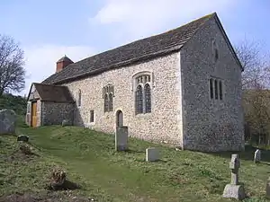
| Coombes Church | |
Coombes 50.8607°N 0.3097°W |
Anglican | I | The nave, entrance door and chancel arch remain from the original 11th-century building. The congregation rebuilt the church (apart from its former tower) after a partial collapse in the 18th century. Important 12th-century and later wall paintings were uncovered in 1949. The churchyard has a rare Tapsel gate—a design unique to Sussex. | [16][34] [35][36] [5][37] [6] |
| Lighthouse Community Church | 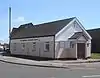 |
Fishersgate 50.8329°N 0.2186°W |
Assemblies of God | – | Originally recorded in 1909 as a mission hall, this became an Evangelical church by the 1930s. It has undergone several name changes, and is now affiliated with the Assemblies of God Pentecostal denomination. | [13][34] [38][39] |
| St Giles' Church | 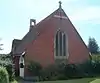 |
Kingston Buci 50.8405°N 0.2614°W |
Anglican | – | This church, built in 1906 in the Decorated Gothic style and attributed to Lacy W. Ridge, was the chapel of the workhouse (now Southlands Hospital) until 1934. It then became part of the parish of St Julian's Church and opened for public worship. | [34][40] [14] |
| St Julian's Church | .jpg.webp) |
Kingston Buci 50.8333°N 0.2466°W |
Anglican | I | The dedication is 12th-century, but the church existed at the time of the Domesday survey and some 11th-century parts survive. There are remains of an anchorite cell, where a hermit lived in medieval times, in the chancel wall. | [14][34] [41][42] [43] |
| St James the Less Church | 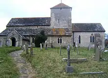 |
Lancing 50.8379°N 0.3226°W |
Anglican | I | A Norman-era doorway is preserved in the south porch at this mostly 13th-century flint-built church. The font survives from the 12th century. The tower was given a new pyramidal cap in the 17th century. | [17][34] [44][45] [46][47] |
| St Michael and All Angels Church | 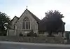 |
Lancing 50.8242°N 0.3233°W |
Anglican | – | A chapel of ease was provided for South Lancing in 1879. It was succeeded by a temporary iron church in 1893, but in 1924 Arthur Young designed a permanent building in the 14th-century Gothic style. A 1950s extension in brick contrasts with the original flint and stone. | [17][34] [44][48] |
| Lancing Tabernacle | 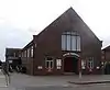 |
Lancing 50.8302°N 0.3220°W |
Evangelical | – | The first church of this name was a Railway Mission hall. The wooden building of 1927 was dismantled and re-erected at Fittleworth when a new Tabernacle, of red brick, opened nearby in 1937. | [17][34] [31][48] [49] |
| Lancing Methodist Church | 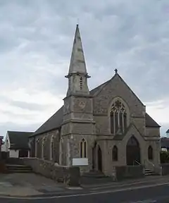 |
Lancing 50.8251°N 0.3228°W |
Methodist | – | A Methodist church existed in South Lancing by 1833 and possibly as early as 1815. Its popularity grew, and in 1904 a larger Early English-style church was built on the site. The 250-capacity building has a tower and spire; a complementary porch was built in 1979. | [17][34] [48][50] |
| Plymouth Brethren Hall | 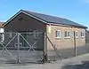 |
Lancing 50.8314°N 0.3261°W |
Plymouth Brethren | – | A Brethren community was established in Lancing in the 1930s. Its first place of worship was in First Avenue, but it later moved to a new building in Wembley Gardens. | [17][34] [51] |
| Church of the Holy Family | 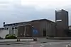 |
Lancing 50.8314°N 0.3217°W |
Roman Catholic | – | A former farmhouse was used for Masses from 1954 and was registered for worship in March of that year. It was later extended, and served Roman Catholics in Lancing and Sompting until a church was built next to it. This new building was registered in January 1971 and consecrated in 1972. | [17][34] [52][53] [54] |
| St Peter the Apostle's Church | 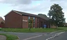 |
Lower Cokeham, Sompting 50.8269°N 0.3389°W |
Anglican | – | This modern brick building is within the parish of St Mary the Blessed Virgin. Consecrated as a church in 1966, it functions as a church hall as well as a place of worship. | [12][34] |
| Lancing Kingdom Hall | Lower Cokeham, Sompting 50.8264°N 0.3341°W |
Jehovah's Witnesses | – | This new Kingdom Hall on Leconfield Road replaced the building in Wembley Avenue used since 1960 and was registered for marriages in February 2014. It serves the Lancing Congregation of Jehovah's Witnesses. | [55] | |
| Church of the Good Shepherd | 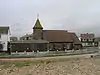 |
Shoreham Beach 50.8263°N 0.2865°W |
Anglican | – | Architect Charles Latham designed this church to serve the Shoreham Beach area, where permanent houses were built to replace the wooden buildings of Bungalow Town—destroyed in a storm in 1913. His Early English-style roughcast-clad building opened in 1913 and was extended in 1971. | [34][40] |
| Providence Strict Baptist Chapel | 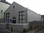 |
Shoreham-by-Sea 50.8325°N 0.2764°W |
Baptist | – | This small stuccoed building, in a simple Classical style with deeply recessed windows, was opened in 1867 to replace a nearby meeting room. The chapel is aligned with the Gospel Standard movement. | [40][56] [57][58] |
| St Mary de Haura Church | .jpg.webp) |
Shoreham-by-Sea 50.8329°N 0.2742°W |
Anglican | I | This church, built to serve the Port of Shoreham, was built on a massive scale in the 11th century—possibly as a collegiate church; its east end has survived and forms the present building. The old chancel became the nave when the church was rebuilt in the 18th century from a ruined state. | [15][34] [59][60] [61][62] |
| St Nicolas' Church | 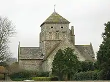 |
Shoreham-by-Sea 50.8408°N 0.2856°W |
Anglican | I | Old Shoreham's church predates the Norman conquest and received its dedication by the 11th century. Much of the present structure was built in about 1140, although it was restored in 1839–1840. The crossing has a set of carved faces. | [15][34] [63][64] [65][66] |
| Shoreham Baptist Church | 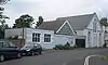 |
Shoreham-by-Sea 50.8344°N 0.2742°W |
Baptist | – | Built in 1880 and since extended to the west, this chapel replaced a smaller predecessor dating from 1870. The Italianate design had stuccoed walls, but these have been painted over. | [34][40] [56][67] |
| Shoreham Free Church | 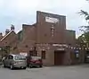 |
Shoreham-by-Sea 50.8352°N 0.2716°W |
Countess of Huntingdon's Connexion | – | Behind the 1958 red-brick façade, the original structure of 1906—built of brick and terracotta—remains. The Countess of Huntingdon's Connexion established its first church in Shoreham in 1800. | [34][40] [56][68] |
| Shoreham Methodist Church |  |
Shoreham-by-Sea 50.8331°N 0.2727°W |
Methodist | – | This was built as a Wesleyan Methodist chapel in 1900. The first such church in Shoreham had opened a century earlier, and another existed from 1829. Josiah Gunton designed a Perpendicular Gothic red-brick and flint building for the congregation. A glass porch was added in 1995. | [34][56] [69][70] |
| St Peter's Church | %252C_Shoreham-by-Sea.jpg.webp) |
Shoreham-by-Sea 50.8341°N 0.2770°W |
Roman Catholic | – | After the town's original Roman Catholic church, also dedicated to Saint Peter, closed in 1982, this new building opened nearby on the site of a Catholic school. Construction started in 1983. | [34][71] [72][73] |
| Church of St Mary the Blessed Virgin | .jpg.webp) |
Sompting 50.8386°N 0.3518°W |
Anglican | I | Renowned for its German-style "Rhenish helm" spire (unique in England) and its Saxon tower, Sompting's parish church retains many 11th- and 12th-century structural elements, including additions made by the Knights Templar and Knights Hospitaller when they held the patronage. | [12][34] [8][9] [74][75] [76] |
| St Michael and All Angels Church | .jpg.webp) |
Southwick 50.8349°N 0.2413°W |
Anglican | II* | Southwick's flint-built parish church was controlled from Kingston Buci in its early years. Most structural work is from the 12th and 13th centuries, but traces of Norman walls remain and the nave dates from the 14th century. The tower was damaged by World War II bombing but was repaired. | [13][34] [77][78] |
| Southwick Christian Community Church | 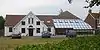 |
Southwick 50.8374°N 0.2370°W |
Congregational Federation | – | Modern additions have hidden the building's origins as a "traditional chapel" built in 1903. This was a stuccoed building with small round-arched windows. A large extension opened to the east in 2003, costing over £1 million. | [13][34] [26][79] [80] |
| Southwick Methodist Church | 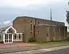 |
Southwick 50.8370°N 0.2341°W |
Methodist | – | Southwick's first Methodist church—now demolished—was active from 1876 to 1955, when its successor (designed by John Leopold Denman) opened. On 4 June 1966 a larger building designed by W.J. Thrasher, linked to the original brick hall by a modern porch structure, was opened. | [13][34] [79][81] [82] |
| St Theresa of Lisieux Church | 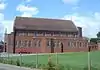 |
Southwick 50.8411°N 0.2375°W |
Roman Catholic | – | Southwick's Roman Catholic community had to travel elsewhere to worship until 1950, when Mass began to be celebrated in a private house. A Romanesque-style church was built on a site next to the Old Shoreham Road in 1955. | [13][34] [83] |
| Sompting United Reformed Church | 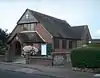 |
Upper Cokeham, Sompting 50.8332°N 0.3362°W |
United Reformed Church | – | The Congregational community established a church in Sompting in 1936 in a brick building. Since the Congregational Church became part of the United Reformed Church in the 1970s, the church has served that denomination. | [12][34] [84] |
Former places of worship
| Name | Image | Location | Denomination/ Affiliation |
Grade | Notes | Refs |
|---|---|---|---|---|---|---|
| St Peter and St Mary's Church | 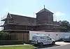 |
Fishersgate 50.8326°N 0.2242°W |
Anglican | – | A mission hall opened in 1881 to serve new housing in this area southeast of Southwick. It was replaced in 1938 by a Romanesque church of dark brickwork and tiles, with a squat tower and spire. It became part of the Parish of Southwick in 2004, was declared redundant in November 2008 and is now the Stepping Stones Children and Family Centre. | [13][79] [85][86] |
| Kingdom Hall | 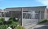 |
Lancing 50.8303°N 0.3265°W |
Jehovah's Witnesses | – | This Kingdom Hall was built in 1960 to serve the Lancing Congregation of Jehovah's Witnesses. In 2009, planning permission was granted for the site to be redeveloped with housing, and it has been replaced by a new building in Leconfield Road. | [17][34] [87][88] |
| First Avenue Hall | Lancing 50.8352°N 0.3187°W |
Plymouth Brethren | – | This was the Brethren community of Lancing's first permanent place of worship. The building stands behind First Avenue and is now empty: the present hall on Wembley Avenue superseded it. | [17][51] | |
| Erringham Chapel | .jpg.webp) |
Old Erringham 50.8569°N 0.2882°W |
Pre-Reformation[note 1] | II | A chapel of ease to St Nicolas' Church at Old Shoreham was built in the now depopulated village of Old Erringham in the 11th century. It was out of use by the time of the Reformation, and the remains of its chancel have been turned into a barn. This now stands on private land and is only visible from a distance. | [15][89] [90][91] [92] |
| St Peter's Church | %252C_Shoreham-by-Sea_(IoE_Code_297316).jpg.webp) |
Shoreham-by-Sea 50.8327°N 0.2769°W |
Roman Catholic | II | Shoreham's first permanent Roman Catholic church was completed in 1875. Charles Alban Buckler's 13th-century Decorated Gothic style design was executed in flint and stone, and featured a bell-turret. Augusta, Duchess of Norfolk funded it. It was replaced by a new church in 1982, and became a nursing home and then flats. | [40][93] [94] |
| West Street Primitive Methodist Chapel | 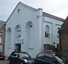 |
Shoreham-by-Sea 50.8330°N 0.2776°W |
Methodist | – | This Classical-style chapel was opened in 1862 for the Primitive Methodist community. When a new chapel opened in 1879, it became a Salvation Army hall. Since the 1930s it has been home to the Shoreham Snooker Club. The round-arched recessed side windows can still be seen. | [69] |
| Southwick Undenominational Mission Hall | Southwick 50.8376°N 0.2396°W |
Non-denominational | – | This mission hall on Cross Road in Southwick was registered for religious worship in 1932. In 1978, planning permission was granted to convert it into a house. | [13][95] | |
See also
Notes
- The church fell out of use before the Reformation, when the Church of England was established.
References
- "Planning (Listed Buildings and Conservation Areas) Act 1990 (c. 9)". The UK Statute Law Database. Ministry of Justice. 24 May 1990. Archived from the original on 24 January 2013. Retrieved 7 April 2015.
- "What English Heritage Does". English Heritage. 2012. Archived from the original on 24 January 2013. Retrieved 7 April 2015.
- "Listed Buildings". English Heritage. 2012. Archived from the original on 24 January 2013. Retrieved 7 April 2015.
- Nairn & Pevsner 1965, p. 252.
- Nairn & Pevsner 1965, pp. 194–195.
- Wales 1999, pp. 67–68.
- Nairn & Pevsner 1965, p. 330.
- Coppin 2006, p. 104.
- "Detailed Record: The Parish Church of St Mary, Church Lane, Sompting, Adur, West Sussex". historicengland.org.uk. English Heritage. 2007. Retrieved 7 April 2015.
- "Area: Adur (Local Authority) – Population Density (UV02)". Neighbourhood Statistics website. Office for National Statistics. 18 November 2004. Archived from the original on 7 April 2015. Retrieved 7 April 2015.
- "West Sussex Local Economic Assessment Spatial Area Factsheets: Adur" (PDF). West Sussex County Council. 2011. p. 11. Archived (PDF) from the original on 7 April 2015. Retrieved 7 April 2015.
- Hudson, T. P. (ed) (1980). "A History of the County of Sussex: Volume 6 Part 1 – Bramber Rape (Southern Part). Sompting". Victoria County History of Sussex. British History Online. pp. 53–64. Retrieved 7 April 2015.CS1 maint: extra text: authors list (link)
- Hudson, T. P. (ed) (1980). "A History of the County of Sussex: Volume 6 Part 1 – Bramber Rape (Southern Part). Southwick". Victoria County History of Sussex. British History Online. pp. 173–183. Retrieved 7 April 2015.CS1 maint: extra text: authors list (link)
- Hudson, T. P. (ed) (1980). "A History of the County of Sussex: Volume 6 Part 1 – Bramber Rape (Southern Part). Kingston by Sea". Victoria County History of Sussex. British History Online. pp. 132–138. Retrieved 7 April 2015.CS1 maint: extra text: authors list (link)
- Hudson, T. P. (ed) (1980). "A History of the County of Sussex: Volume 6 Part 1 – Bramber Rape (Southern Part). Old and New Shoreham – Churches". Victoria County History of Sussex. British History Online. pp. 167–171. Retrieved 7 April 2015.CS1 maint: extra text: authors list (link)
- Hudson, T. P. (ed) (1980). "A History of the County of Sussex: Volume 6 Part 1 – Bramber Rape (Southern Part). Coombes". Victoria County History of Sussex. British History Online. pp. 215–219. Retrieved 7 April 2015.CS1 maint: extra text: authors list (link)
- Hudson, T. P. (ed) (1980). "A History of the County of Sussex: Volume 6 Part 1 – Bramber Rape (Southern Part). Lancing". Victoria County History of Sussex. British History Online. pp. 34–53. Retrieved 7 April 2015.CS1 maint: extra text: authors list (link)
- "Area: Adur (Local Authority) – Religion, 2011 (KS209EW)". Neighbourhood Statistics website. Office for National Statistics. 30 January 2013. Archived from the original on 7 April 2015. Retrieved 7 April 2015.
- "Deaneries & Parishes". Diocese of Chichester. 2015. Archived from the original on 7 April 2015. Retrieved 7 April 2015.
- "Deanery of Worthing". A Church Near You website. Archbishops' Council. 2015. Archived from the original on 7 April 2015. Retrieved 7 April 2015.
- "Deanery of Hove". A Church Near You website. Archbishops' Council. 2015. Archived from the original on 7 April 2015. Retrieved 7 April 2015.
- "Arundel Cathedral Parish". Diocese of Arundel and Brighton website. DABNet. 2015. Archived from the original on 7 April 2015. Retrieved 7 April 2015.
- "Adur Valley, West Sussex". Diocese of Arundel and Brighton website. DABNet. 2015. Archived from the original on 7 April 2015. Retrieved 7 April 2015.
- "Southwick with Portslade, West Sussex". Diocese of Arundel and Brighton website. DABNet. 2015. Archived from the original on 7 April 2015. Retrieved 7 April 2015.
- "East Worthing, West Sussex". Diocese of Arundel and Brighton website. DABNet. 2015. Archived from the original on 7 April 2015. Retrieved 7 April 2015.
- "Southwick – Christian Community". Congregational Federation. 2015. Archived from the original on 7 April 2015. Retrieved 7 April 2015.
- "Church Finder – Search Results (South-East Area)". Congregational Federation. 2015. Archived from the original on 7 April 2015. Retrieved 7 April 2015.
- "Who we are". Congregational Federation. 2015. Archived from the original on 7 April 2015. Retrieved 7 April 2015.
- "History of the Church". Southwick Christian Community Church. 2010. Archived from the original on 7 April 2015. Retrieved 7 April 2015.
- "Church Finder". Baptist Union of Great Britain. 2015. Archived from the original on 7 April 2015. Retrieved 7 April 2015. (Search for "Shoreham-by-Sea" in town name)
- "Welcome to Lancing Tab..." Lancing Tabernacle. 2015. Archived from the original on 7 April 2015. Retrieved 7 April 2015.
- "Churches". Worthing Methodist Circuit. 2015. Archived from the original on 7 April 2015. Retrieved 7 April 2015.
- "Church Finder". Congregational Federation. 2021. Archived from the original on 24 January 2021. Retrieved 24 January 2021.
- "Churches, religions and current places of worship". Adur District Council. 1 November 2005. Archived from the original on 17 December 2009. Retrieved 7 April 2015.
- Coppin 2006, p. 107.
- "Detailed Record: The Parish Church, Coombes Road, Coombes, Adur, West Sussex". historicengland.org.uk. English Heritage. 2007. Retrieved 7 April 2015.
- Pé 2006, p. 46.
- Registered in accordance with the Places of Worship Registration Act 1855 (Number in Worship Register: 53501; Name: The Lighthouse Christian Centre; Address: St Aubyn's Road, Fishersgate; Denomination: Christians not otherwise designated). Retrieved 22 October 2012. (Archived version of list from April 2010; Click here for access to subsequent updates)
- "The Lighthouse Community Church". Assemblies of God Incorporated. 2015. Archived from the original on 19 April 2015. Retrieved 7 April 2015.
- Elleray 2004, p. 49.
- "Detailed Record: Church of St Julian, St Julians Lane (south side), Shoreham by Sea, Adur, West Sussex". historicengland.org.uk. English Heritage. 2007. Retrieved 11 July 2009.
- Coppin 2006, p. 132.
- Nairn & Pevsner 1965, pp. 252–253.
- Wales 1999, p. 134.
- "Detailed Record: The Parish Church of St James, Manor Road, Lancing, Adur, West Sussex". historicengland.org.uk. English Heritage. 2007. Retrieved 11 July 2009.
- Coppin 2006, p. 105.
- Nairn & Pevsner 1965, pp. 255–256.
- Elleray 2004, p. 37.
- Registered in accordance with the Places of Worship Registration Act 1855 (Number in Worship Register: 57762; Name: Lancing Tabernacle; Address: North Road, Lancing; Denomination: Independent Evangelical Church). Retrieved 22 October 2012. (Archived version of list from April 2010; Click here for access to subsequent updates)
- Registered in accordance with the Places of Worship Registration Act 1855 (Number in Worship Register: 40386; Name: Methodist Church; Address: Lancing; Denomination: Methodist Church). Retrieved 22 October 2012. (Archived version of list from April 2010; Click here for access to subsequent updates)
- Registered in accordance with the Places of Worship Registration Act 1855 (Number in Worship Register: 74826; Name: Meeting Room; Address: Rear of Dorset Lodge, First Avenue, Lancing; Denomination: Christians not otherwise designated). Retrieved 22 October 2012. (Archived version of list from April 2010; Click here for access to subsequent updates)
- Registered in accordance with the Places of Worship Registration Act 1855 (Number in Worship Register: 72401; Name: Church of the Holy Family; Address: North Road, Lancing; Denomination: Roman Catholics). Retrieved 22 October 2012. (Archived version of list from April 2010; Click here for access to subsequent updates)
- "No. 45282". The London Gazette. 15 January 1971. p. 632.
- "No. 45280". The London Gazette (Supplement). 14 January 1971. p. 486.
- "No. 60786". The London Gazette. 20 February 2014. p. 3750.
- Hudson, T. P. (ed) (1980). "A History of the County of Sussex: Volume 6 Part 1 – Bramber Rape (Southern Part). Old and New Shoreham – Protestant Nonconformity". Victoria County History of Sussex. British History Online. pp. 171–172. Retrieved 7 April 2015.CS1 maint: extra text: authors list (link)
- "List of Chapels and Times of Services" (PDF). Gospel Standard Trust Publications. 2009. Archived from the original (PDF) on 14 February 2013. Retrieved 14 February 2013.
- Registered in accordance with the Places of Worship Registration Act 1855 (Number in Worship Register: 18142; Name: Providence Chapel; Address: John Street, Shoreham-by-Sea; Denomination: Baptists). Retrieved 22 October 2012. (Archived version of list from April 2010; Click here for access to subsequent updates)
- "Detailed Record: Church of St Mary de Haura, Church Street (east side), Shoreham by Sea, Adur, West Sussex". historicengland.org.uk. English Heritage. 2007. Retrieved 11 July 2009.
- Coppin 2006, p. 116.
- Nairn & Pevsner 1965, pp. 276–282.
- Pé 2006, p. 93.
- Coppin 2006, p. 115.
- Nairn & Pevsner 1965, pp. 285–287.
- Pé 2006, pp. 91–93.
- "Detailed Record: Church of St Nicolas, St Nicolas Lane (north side), Shoreham by Sea, Adur, West Sussex". historicengland.org.uk. English Heritage. 2007. Retrieved 4 August 2009.
- Registered in accordance with the Places of Worship Registration Act 1855 (Number in Worship Register: 25256; Name: Baptist Chapel; Address: Western Road, Shoreham-by-Sea; Denomination: Baptists). Retrieved 22 October 2012. (Archived version of list from April 2010; Click here for access to subsequent updates)
- Registered in accordance with the Places of Worship Registration Act 1855 (Number in Worship Register: 63163; Name: Shoreham Free Church; Address: Gordon Road, Shoreham-by-Sea; Denomination: Countess Of Huntingdon's Connexion). Retrieved 22 October 2012. (Archived version of list from April 2010; Click here for access to subsequent updates)
- Elleray 2004, p. 50.
- Registered in accordance with the Places of Worship Registration Act 1855 (Number in Worship Register: 37655; Name: Methodist Church; Address: Brunswick Road, Shoreham-by-Sea; Denomination: Methodist Church). Retrieved 22 October 2012. (Archived version of list from April 2010; Click here for access to subsequent updates)
- Norman 1989, p. 13.
- Colquhoun 2008, p. 29.
- Registered in accordance with the Places of Worship Registration Act 1855 (Number in Worship Register: 76540; Name: St Peter's Church; Address: West Street, Shoreham-by-Sea; Denomination: Roman Catholics). Retrieved 22 October 2012. (Archived version of list from April 2010; Click here for access to subsequent updates)
- Pé 2006, p. 39.
- Nairn & Pevsner 1965, pp. 330–332.
- Wales 1999, p. 196.
- "Detailed Record: Church of St Michael, Church Lane (south side), Shoreham by Sea, Adur, West Sussex". historicengland.org.uk. English Heritage. 2007. Retrieved 11 July 2009.
- Nairn & Pevsner 1965, pp. 334–335.
- Elleray 2004, p. 51.
- Registered in accordance with the Places of Worship Registration Act 1855 (Number in Worship Register: 40767; Name: Southwick Christian Community Church; Address: Corner of Green and Southview Road, Southwick; Denomination: Congregationalists). Retrieved 22 October 2012. (Archived version of list from April 2010; Click here for access to subsequent updates)
- Registered in accordance with the Places of Worship Registration Act 1855 (Number in Worship Register: 70546; Name: Methodist Church; Address: Manor Hall Road, Southwick; Denomination: Methodist Church). Retrieved 22 October 2012. (Archived version of list from April 2010; Click here for access to subsequent updates)
- "Our History". Southwick Methodist Church. 2015. Archived from the original on 7 April 2015. Retrieved 7 April 2015.
- Registered in accordance with the Places of Worship Registration Act 1855 (Number in Worship Register: 65064; Name: St Theresa; Address: Old Shoreham Road, Southwick; Denomination: Roman Catholics). Retrieved 22 October 2012. (Archived version of list from April 2010; Click here for access to subsequent updates)
- Registered in accordance with the Places of Worship Registration Act 1855 (Number in Worship Register: 57951; Name: Sompting United Reformed Church; Address: Cokeham Road, Sompting; Denomination: United Reformed Church). Retrieved 22 October 2012. (Archived version of list from April 2010; Click here for access to subsequent updates)
- "St Peter & St Mary, Fishersgate". A Church Near You website. Archbishops' Council. 2015. Archived from the original on 7 April 2015. Retrieved 7 April 2015.
- "Stepping Stones Children and Family Centre (Fishersgate)". West Sussex County Council. 12 November 2014. Archived from the original on 7 April 2015. Retrieved 7 April 2015.
- "Application Summary (ADC/0036/09)". Adur District Council planning application. Adur District Council/CAPS Solutions Ltd. 26 January 2009. Archived from the original on 7 April 2015. Retrieved 7 April 2015.
Redevelopment with 6 one-bedroom dwellings with 3 parking spaces (accessed from east side of Wembley Gardens) (outline with access details): Kingdom Hall, Wembley Gardens, Lancing, West Sussex
- Registered in accordance with the Places of Worship Registration Act 1855 (Number in Worship Register: 71500; Name: Kingdom Hall; Address: Wembley Gardens, Wembley Avenue, Lancing; Denomination: Jehovah's Witnesses). Retrieved 22 October 2012. (Archived version of list from April 2010; Click here for access to subsequent updates)
- Nairn & Pevsner 1965, p. 287.
- Vincent 2005, p. 46.
- "Detailed Record: Remains of Chapel to southwest of No.1 and No.2 (Old Erringham Farm Cottages), Steyning Road (east side), Shoreham by Sea, Adur, West Sussex". historicengland.org.uk. English Heritage. 2007. Retrieved 7 April 2015.
- Vigar 1994, p. 64.
- "Detailed Record: Church of St Peter, Ship Street (east side), Shoreham by Sea, Adur, West Sussex". historicengland.org.uk. English Heritage. 2007. Retrieved 22 September 2009.
- Hudson, T. P. (ed) (1980). "A History of the County of Sussex: Volume 6 Part 1 – Bramber Rape (Southern Part). Old and New Shoreham – Roman Catholicism". Victoria County History of Sussex. British History Online. p. 171. Retrieved 7 April 2015.CS1 maint: extra text: authors list (link)
- "Application Summary (SW/12/78/TP/8600)". Adur District Council Planning Application SW/12/78/TP/8600. Adur District Council. 12 January 1978. Archived from the original on 7 April 2015. Retrieved 7 April 2015.
Change of Use from Mission Hall to Residential: Southwick Undenominational Mission, 17 Cross Road, Southwick
Bibliography
- Colquhoun, Edward W. (2008). Shoreham – In Times of Change. Shoreham-by-Sea: Marlipins Museum.
- Coppin, Paul (2006). 101 Medieval Churches of West Sussex. Seaford: S.B. Publications. ISBN 1-85770-306-5.
- Elleray, D. Robert (1981). The Victorian Churches of Sussex. Chichester: Phillimore & Co. Ltd. ISBN 0-85033-378-4.
- Elleray, D. Robert (2004). Sussex Places of Worship. Worthing: Optimus Books. ISBN 0-9533132-7-1.
- Nairn, Ian; Pevsner, Nikolaus (1965). The Buildings of England: Sussex. Harmondsworth: Penguin Books. ISBN 0-14-071028-0.
- Norman, Michael (1989). A Walkabout Guide to Shoreham (2nd ed.). Shoreham-by-Sea: Marlipins Museum.
- Pé, Diana (2006). Mid Sussex Church Walks. PP (Pé Publishing). ISBN 0-9543690-2-5.
- Vigar, John (1994). The Lost Villages of Sussex. Stanbridge: The Dovecote Press Ltd. ISBN 1-874336-29-6.
- Vincent, Alex (2005). The Lost Churches and Chapels of Sussex. Seaford: S.B. Publications. ISBN 1-85770-303-0.
- Wales, Tony (1999). The West Sussex Village Book. Newbury: Countryside Books. ISBN 1-85306-581-1.
- Whitman, Ken; Whitman, Joyce (1994). Ancient Churches of Sussex. Brighton: Roedale Books. ISBN 0-9522560-0-2.
Places of worship in Sussex (by district) | ||
|---|---|---|
| East Sussex | .jpg.webp) | |
| West Sussex | ||
| Demolished | ||
| Cathedrals | ||
| Styles |  | |
|---|---|---|
| Buildings and structures | ||
| Other | ||
Category | ||