List of road routes in the Australian Capital Territory
Road routes in the Australian Capital Territory assist drivers navigating roads. Many major roads in the ACT are not assigned a route number.
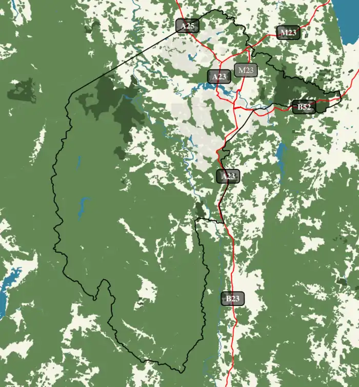
Current routes
| Route | Component roads | From | Via (Districts) | To | Length | Notes |
|---|---|---|---|---|---|---|
M23 |
ACT–NSW border at Sutton, New South Wales | Canberra Avenue/Monaro Highway junction at Fyshwick–Symonston–Narrabundah triple point | 14.1 km (8.8 mi)[2] | Continues south as A23 Continues northeast into NSW as M23 | ||
A23 |
|
Majura Parkway junction in Majura | ACT–NSW border at Williamsdale, New South Wales | 51.8 km (32.2 mi)[3] | Continues south into NSW as B23 | |
B23 |
Monaro Highway | Fyshwick | Calwell | NSW Border | Formerly | |
A25 |
A23 junction at the Lyneham–Downer boundary | ACT–NSW border at Wallaroo, New South Wales | 11.9 km (7.4 mi)[4] | Continues northwest into NSW as A25 | ||
B52 |
|
First Section: A23 junction at the Fyshwick–Symonston boundary Second (Kowen) Section: ACT–NSW border at Carwoola, New South Wales |
|
First Section: ACT–NSW border at Queanbeyan West–Crestwood, New South Wales boundary Second (Kowen) Section: ACT–NSW border at Bungendore, New South Wales |
4.2 km (2.6 mi)[5] 7.5 km (4.7 mi)[6] |
Continues east into NSW as B52 |
Proposed but cancelled routes[7]
| Route | Component roads | From | Via (Districts) | To | Length | Notes |
|---|---|---|---|---|---|---|
A230 |
|
Majura Parkway junction in Majura | ACT–NSW border at Williamsdale, New South Wales | 51.8 km (32.2 mi)[3] | It is now A23. It was proposed to be changed to avoid duplicate numbers with the M23 | |
B250 |
Gungahlin Dr, Caswell Dr, Tuggeranong Pwy, Drakeford Dr and Tharwa Dr |
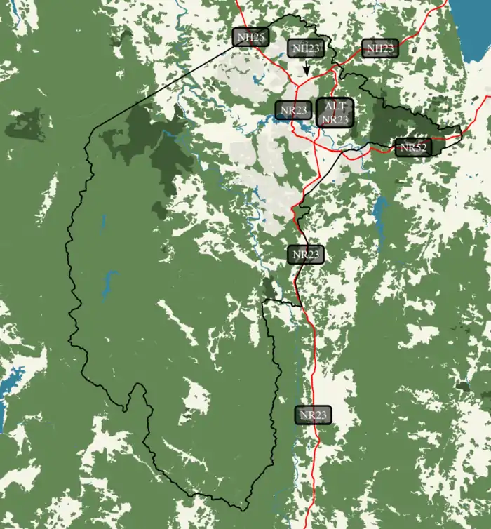
Former routes
| Route | Component roads | From | Via (Districts) | To | Length | Notes |
|---|---|---|---|---|---|---|
National Highway 23 |
NH25 and NR23 terminus at the Lyneham–Downer boundary | ACT–NSW border at Sutton, New South Wales | 7.1 km (4.4 mi)[9] | Replaced by M23 and A23 | ||
National Highway 25 |
NH23 and NR23 terminus at the Lyneham–Downer boundary | ACT–NSW border at Wallaroo, New South Wales | 11.9 km (7.4 mi)[4] | Replaced by A25 | ||
National Route 23 |
NH23 and NH25 terminus at the Lyneham–Downer boundary | ACT–NSW border at Williamsdale, New South Wales | 44.7 km (27.8 mi)[10] | Replaced by A23 | ||
Alternate National Route 23 |
|
NH23 junction at the Gungahlin–Majura district boundary | NR23 junction and NR52 terminus at the Fyshwick–Symonston–Narrabundah triple point |
15.1 km (9.4 mi)[11] | Largely replaced by M23 | |
National Route 52 |
|
First Section: NR23 junction and ALT NR23 terminus at the Fyshwick–Symonston–Narrabundah triple point Second (Kowen) Section: ACT–NSW border at Carwoola, New South Wales |
|
First Section: ACT–NSW border at Queanbeyan West–Crestwood, New South Wales boundary Second (Kowen) Section: ACT–NSW border at Bungendore, New South Wales |
4.6 km (2.9 mi)[12] 7.5 km (4.7 mi)[6] |
Largely replaced by B52 Replaced by B52 |
References
- "Guide Signs MIS 12" (PDF). ACT Government. April 2019. p. 13. Retrieved 9 June 2020.
- Google (21 June 2020). "Driving directions to Monaro Hwy/National Route 23" (Map). Google Maps. Google. Retrieved 21 June 2020.
- Google (21 June 2020). "Driving directions to Federal Hwy/M23/National Highway 23" (Map). Google Maps. Google. Retrieved 21 June 2020.
- Google (5 October 2013). "Driving directions to Barton Hwy/National Highway 25" (Map). Google Maps. Google. Retrieved 5 October 2013.
- Google (21 June 2020). "Driving directions to Canberra Ave/National Route 52" (Map). Google Maps. Google. Retrieved 21 June 2020.
- Google (5 October 2013). "Driving directions to Kings Hwy/National Route 52" (Map). Google Maps. Google. Retrieved 5 October 2013.
- (PDF). 11 November 2018 https://web.archive.org/web/20181111022731/https://www.tccs.act.gov.au/__data/assets/pdf_file/0011/808859/MIS12-Guide-signs-Ed0-Rev0.pdf. Archived from the original (PDF) on 11 November 2018. Retrieved 23 September 2020. Missing or empty
|title=(help) - "Trunk Road Infrastructure Standard No .03 – Traffic Management" (PDF). Attachment A – Road Signs. Territory and Municipal Services. October 2012. pp. 7, 18, 24–25. Retrieved 5 October 2013.
- Google (5 October 2013). "Driving directions to Federal Hwy/M23/National Highway 23" (Map). Google Maps. Google. Retrieved 5 October 2013.
- Google (5 October 2013). "Driving directions to Monaro Hwy/National Route 23" (Map). Google Maps. Google. Retrieved 5 October 2013.
- Google (5 October 2013). "Driving directions to Monaro Hwy/National Route Alt 23" (Map). Google Maps. Google. Retrieved 5 October 2013.
- Google (5 October 2013). "Driving directions to Canberra Ave/National Route 52" (Map). Google Maps. Google. Retrieved 5 October 2013.
This article is issued from Wikipedia. The text is licensed under Creative Commons - Attribution - Sharealike. Additional terms may apply for the media files.