Lockyer, Western Australia
Lockyer is a north-western suburb of Albany in southern Western Australia. Its local government area is the City of Albany. The suburb has a median age of 33, and was officially named in 1954.[2]
| Lockyer Albany, Western Australia | |||||||||||||||
|---|---|---|---|---|---|---|---|---|---|---|---|---|---|---|---|
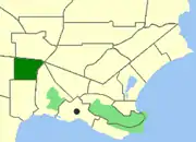 Map of Lockyer within Albany | |||||||||||||||
| Population | 1,150 (2011 census)[1] | ||||||||||||||
| • Density | 880/km2 (2,290/sq mi) | ||||||||||||||
| Postcode(s) | 6330 | ||||||||||||||
| Area | 1.3 km2 (0.5 sq mi) | ||||||||||||||
| Location | 4 km (2 mi) from Albany | ||||||||||||||
| LGA(s) | City of Albany | ||||||||||||||
| State electorate(s) | Albany | ||||||||||||||
| Federal Division(s) | O'Connor | ||||||||||||||
| |||||||||||||||
Geography
Lockyer is bounded to the North by the South Coast Highway, to the east by Hanrahan Road, to the south by Cuming Road and to the west by Cull Road.
Facilities
The suburb has a local primary school within its boundaries, Mount Lockyer Primary School. Local students would attend North Albany Senior High School in Milpara for secondary education.
References
- Australian Bureau of Statistics (31 October 2012). "Lockyer (State Suburb)". 2011 Census QuickStats. Retrieved 4 January 2015.

- "Naming of Localities at Albany (per 8175/50)". Western Australia Government Gazette. 27 August 1954. p. 1954:1494.
This article is issued from Wikipedia. The text is licensed under Creative Commons - Attribution - Sharealike. Additional terms may apply for the media files.