Longeville-sur-Mer
Longeville-sur-Mer is a commune in the Vendée department in the Pays de la Loire region in western France.
Longeville-sur-Mer | |
|---|---|
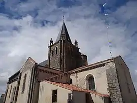 The church of Our Lady of the Assumption | |
 Coat of arms | |
Location of Longeville-sur-Mer 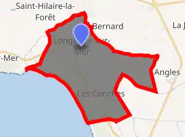
| |
 Longeville-sur-Mer  Longeville-sur-Mer | |
| Coordinates: 46°25′31″N 1°29′18″W | |
| Country | France |
| Region | Pays de la Loire |
| Department | Vendée |
| Arrondissement | Les Sables-d'Olonne |
| Canton | Talmont-Saint-Hilaire |
| Government | |
| • Mayor (2008–2014) | Michel Bridonneau |
| Area 1 | 38.05 km2 (14.69 sq mi) |
| Population (2017-01-01)[1] | 2,466 |
| • Density | 65/km2 (170/sq mi) |
| Time zone | UTC+01:00 (CET) |
| • Summer (DST) | UTC+02:00 (CEST) |
| INSEE/Postal code | 85127 /85560 |
| Elevation | 0–30 m (0–98 ft) (avg. 20 m or 66 ft) |
| 1 French Land Register data, which excludes lakes, ponds, glaciers > 1 km2 (0.386 sq mi or 247 acres) and river estuaries. | |
Geography
North of the Marais Poitevin, Longeville-sur-Mer is situated in the south of the Vendée department, along the Côte de Lumière (English: Coast of Light). The commune gives its name to a coastal forest of pines and oaks. The town's central village lies one kilometre inland, but the municipality itself comprises three smaller seaside resorts, these beings the hamlets of 'Le Bouil', 'Le Rocher' and 'Les Conches'. A celebrated surf spot, named Bud Bud, is found at Les Conches, whilst the road leading from the beach to the nearby town of Angles passes through a marsh, from which one may observe wild birds, including storks.
Demographics
As of the 2008 census, Longeville-sur-Mer had a population of 2,328 (an increase of 18% as compared to 1999). The commune ranks as the 4,337th largest in France (4,676th in 1999) and the 72nd largest of the 282 communes in the department.
See also
References
- "Populations légales 2017". INSEE. Retrieved 6 January 2020.
| Wikimedia Commons has media related to Longeville-sur-Mer. |
| Authority control |
|
|---|