Saint-Cyr-des-Gâts
Saint-Cyr-des-Gâts is a commune in the Vendée department in the Pays de la Loire region in western France.
Saint-Cyr-des-Gâts | |
|---|---|
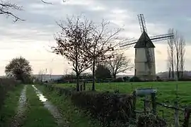 The windmill in Saint-Cyr-des-Gâts | |
Location of Saint-Cyr-des-Gâts 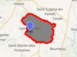
| |
 Saint-Cyr-des-Gâts  Saint-Cyr-des-Gâts | |
| Coordinates: 46°34′12″N 0°53′00″W | |
| Country | France |
| Region | Pays de la Loire |
| Department | Vendée |
| Arrondissement | Fontenay-le-Comte |
| Canton | La Châtaigneraie |
| Intercommunality | Pays de l'Hermenault |
| Government | |
| • Mayor (2008–2014) | Michel Garnier |
| Area 1 | 21.08 km2 (8.14 sq mi) |
| Population (2017-01-01)[1] | 534 |
| • Density | 25/km2 (66/sq mi) |
| Time zone | UTC+01:00 (CET) |
| • Summer (DST) | UTC+02:00 (CEST) |
| INSEE/Postal code | 85205 /85410 |
| Elevation | 49–132 m (161–433 ft) |
| 1 French Land Register data, which excludes lakes, ponds, glaciers > 1 km2 (0.386 sq mi or 247 acres) and river estuaries. | |
Geography
The river Smagne forms all of the commune's southern border.
See also
References
- "Populations légales 2017". INSEE. Retrieved 6 January 2020.
| Wikimedia Commons has media related to Saint-Cyr-des-Gâts. |
| Authority control |
|---|
This article is issued from Wikipedia. The text is licensed under Creative Commons - Attribution - Sharealike. Additional terms may apply for the media files.