Louisville, Georgia
Louisville is a city in Jefferson County, Georgia, United States. It is a former state capital of Georgia and is the county seat of Jefferson County.[7] It is located southwest of Augusta on the Ogeechee River, and its population was 2,493 at the 2010 census,[8] down from 2,712 at the 2000 census. The name is of French origin, but is pronounced "Lewis-ville" by locals.[9]
Louisville, Georgia | |
|---|---|
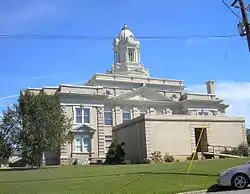 Jefferson County Courthouse | |
| Motto(s): "A Capital Community" | |
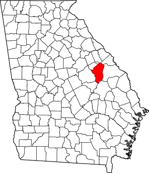
 Location in Jefferson County and the state of Georgia | |
 Louisville Location of Louisville in the US | |
| Coordinates: 33°0′15″N 82°24′17″W | |
| Country | |
| State | |
| County | Jefferson |
| Incorporated | January 26, 1786[1] |
| Named for | Louis XVI |
| Government | |
| • Type | Mayor–Council |
| • Mayor | Larry Morgan |
| • Council | Members
|
| Area | |
| • Total | 3.68 sq mi (9.53 km2) |
| • Land | 3.61 sq mi (9.34 km2) |
| • Water | 0.07 sq mi (0.18 km2) |
| Elevation | 322 ft (98 m) |
| Population (2010) | |
| • Total | 2,493 |
| • Estimate (2019)[4] | 2,215 |
| • Density | 614.08/sq mi (237.09/km2) |
| Time zone | UTC-5 (Eastern (EST)) |
| • Summer (DST) | UTC-4 (EDT) |
| ZIP code(s) | 30434 |
| Area code(s) | 478 |
| FIPS code | 13-47560[5] |
| GNIS feature ID | 0332271[6] |
| Major airport | AGS |
| Website | cityoflouisvillegeorgia |
History
.jpg.webp)
Louisville was incorporated on January 26, 1786, as the prospective state capital. Savannah had served as the colonial capital, but was considered too far from the center of population in the growing state. Louisville was named for Louis XVI, who was still the King of France and had aided the Continentals during the successful American Revolutionary War. Development of the city began later, and its state government buildings were completed in 1795. An old Revolutionary War Soldiers Cemetery is located on the western side of town.
The city of Louisville served as the state capital of Georgia from 1796 to 1806. It was a center of trade, legislators and political influence. The Jefferson County courthouse, built in 1904, stands on the site of Georgia's first permanent capitol building.[10]
Louisville's historic, open-sided market house, Old Market, still stands in the center of downtown. The original market had sections for sales of farm produce, household goods, and enslaved African Americans. The city of Louisville and state of Georgia are backing off the claim that it was a slave market. The caption of a 1934 photograph in the Library of Congress says otherwise; with details. https://www.loc.gov/item/ga0248/ The Old Market is listed on the National Register of Historic Places. Roads and other transportation routes intersected at the market square, the hub of the region when the town was the state capital. The state capital was moved to Milledgeville and later to Atlanta, in the Piedmont.
As a small city and county seat, Louisville now has few major businesses and industries. A marker dedicated to the Yazoo land scandal of the 19th century is located in front of the Jefferson County Courthouse. Queensborough National Bank and Trust Company was founded in 1902 and is currently headquartered in Louisville, on U.S. Highway 1.
Geography
Louisville is located slightly south of the center of Jefferson County at 33°0′15″N 82°24′18″W (33.004291, -82.404588).[11] U.S. Route 1 passes through the east side of the city, leading northeast 46 miles (74 km) to Augusta and south 30 miles (48 km) to Swainsboro. U.S. Route 221 passes through the north side of downtown as Peachtree Street and leads southwest 10 miles (16 km) to Bartow. US-221 leaves Louisville to the north, running with US-1 15 miles (24 km) to Wrens before continuing north toward Harlem.
According to the United States Census Bureau, Louisville has a total area of 3.7 square miles (9.5 km2), of which 3.6 square miles (9.3 km2) are land and 0.1 square miles (0.2 km2), or 1.93%, are water.[8] The western city boundary follows Rocky Comfort Creek, which flows into the Ogeechee River at the city limits' southwest corner. The Ogeechee flows to the Atlantic Ocean south of Savannah.
Demographics
| Historical population | |||
|---|---|---|---|
| Census | Pop. | %± | |
| 1810 | 524 | — | |
| 1820 | 694 | 32.4% | |
| 1870 | 356 | — | |
| 1880 | 575 | 61.5% | |
| 1890 | 836 | 45.4% | |
| 1900 | 1,009 | 20.7% | |
| 1910 | 1,039 | 3.0% | |
| 1920 | 1,040 | 0.1% | |
| 1930 | 1,650 | 58.7% | |
| 1940 | 1,803 | 9.3% | |
| 1950 | 2,231 | 23.7% | |
| 1960 | 2,413 | 8.2% | |
| 1970 | 2,691 | 11.5% | |
| 1980 | 2,823 | 4.9% | |
| 1990 | 2,429 | −14.0% | |
| 2000 | 2,712 | 11.7% | |
| 2010 | 2,493 | −8.1% | |
| 2019 (est.) | 2,215 | [4] | −11.2% |
| U.S. Decennial Census[12] | |||
As of the census[5] of 2000, there were 2,712 people, 994 households, and 664 families residing in the city. The population density was 755.5 people per square mile (291.7/km2). There were 1,123 housing units at an average density of 312.8 per square mile (120.8/km2). The racial makeup of the city was 65.93% African American, 33.63% White, 0.04% Native American, 0.22% Asian, 0.07% from other races, and 0.11% from two or more races. Hispanic or Latino of any race were 0.37% of the population.
There were 994 households, out of which 33.4% had children under the age of 18 living with them, 35.8% were married couples living together, 27.4% had a female householder with no husband present, and 33.1% were non-families. 31.4% of all households were made up of individuals, and 16.1% had someone living alone who was 65 years of age or older. The average household size was 2.56 and the average family size was 3.22.
In the city, the population was spread out, with 28.2% under the age of 18, 8.3% from 18 to 24, 25.1% from 25 to 44, 19.9% from 45 to 64, and 18.5% who were 65 years of age or older. The median age was 37 years. For every 100 females, there were 77.7 males. For every 100 females age 18 and over, there were 71.8 males.
The median income for a household in the city was $19,883, and the median income for a family was $32,578. Males had a median income of $31,500 versus $16,921 for females. The per capita income for the city was $15,028. About 23.1% of families and 28.9% of the population were below the poverty line, including 27.8% of those under age 18 and 51.8% of those age 65 or over.
Education
Jefferson County School District
The Jefferson County School District holds pre-school to grade twelve, and consists of two elementary schools, two middle schools, a high school, and an academy school.[13] The district has 199 full-time teachers and over 3,526 students.[14]
- Louisville Academy
- Carver Elementary School
- Wrens Elementary School
- Jefferson County Middle School
- Jefferson County High School
Private education
See also
- Central Savannah River Area
- List of municipalities in Georgia (U.S. state)
- Local radio station: WPEH, Big Peach Radio (92.1 FM and 1420 AM)
- National Register of Historic Places listings in Jefferson County, Georgia
References
- Holmes, Yulssus Lynn (1996). Those Glorious Days: A History of Louisville as Georgia's Capital, 1796-1807. Macon, Georgia: Mercer University Press. p. 26. ISBN 0-86554-527-8. LCCN 96030440. OCLC 35084837. OL 992000M.
- "City Officials". City of Louisville, Georgia. 2017. Archived from the original on May 9, 2017. Retrieved May 17, 2017.
- "2019 U.S. Gazetteer Files". United States Census Bureau. Retrieved July 9, 2020.
- "Population and Housing Unit Estimates". United States Census Bureau. May 24, 2020. Retrieved May 27, 2020.
- "U.S. Census website". United States Census Bureau. Retrieved January 31, 2008.
- "US Board on Geographic Names". United States Geological Survey. October 25, 2007. Archived from the original on February 12, 2012. Retrieved January 31, 2008.
- "Find a County". National Association of Counties. Archived from the original on May 31, 2011. Retrieved June 7, 2011.
- "Geographic Identifiers: 2010 Census Summary File 1 (G001): Louisville city, Georgia". American Factfinder. U.S. Census Bureau. Archived from the original on February 13, 2020. Retrieved May 4, 2018.
- Krakow, Kenneth K. (1975). Georgia Place-Names: Their History and Origins (PDF). Macon, GA: Winship Press. p. 137. ISBN 0-915430-00-2. Archived (PDF) from the original on March 11, 2016. Retrieved March 13, 2019.
- Louisville Archived August 6, 2013, at the Wayback Machine, Georgia.gov, accessed August 27, 2013.
- "US Gazetteer files: 2010, 2000, and 1990". United States Census Bureau. February 12, 2011. Retrieved April 23, 2011.
- "Census of Population and Housing". Census.gov. Retrieved June 4, 2015.
- Georgia Board of Education, Retrieved June 20, 2010.
- School Stats Archived November 25, 2011, at the Wayback Machine, Retrieved June 20, 2010.
Further reading
- Strong, Robert Hale (1961). Halsey, Ashley (ed.). A Yankee Private's Civil War. Chicago: Henry Regnery Company. pp. 106–108. LCCN 61-10744. OCLC 1058411.
External links
- Government
- General information
 Geographic data related to Louisville, Georgia at OpenStreetMap
- Louisville, Georgia at the Digital Library of Georgia
- Louisville, Georgia at Jefferson County Chamber of Commerce and Development Authority of Jefferson County (jeffersoncounty.org)
- Louisville, Georgia at New Georgia Encyclopedia
- Louisville Public Library at Jefferson County Library System
- The Sacking of Louisville at The Historical Marker Database (HMdb.org)
| |||||||||||||||||||||
| Authority control |
|---|