Luís Vaz de Torres
Luís Vaz de Torres (Galician and Portuguese), or Luis Váez de Torres in the Spanish spelling (born c. 1565; fl. 1607), was a 16th- and 17th-century maritime explorer of a Spanish expedition noted for the first recorded European navigation of the strait that separates the Australian mainland from the island of New Guinea, and which now bears his name (Torres Strait).

Origins and early life
Captain Luis Váez de Torres was recorded as being called a "Breton" by crewmen in reports of the 1606 –1608 voyage,[1] which points to an origin in the northwest province of Spain, i. e., Galicia. Most contemporary historians accept this as evidence of his origins.[2][3][4][5] The year and exact place of his birth are unknown; assuming him to have been in his late thirties or forties in 1606, a birth year of around 1565 is considered likely.
Torres has been presented by some writers as Portuguese, without any evidence other than his name.[6][7][8] Galician spelling at the time being indistinguishable from Portuguese. Records never call Torres Portuguese but note remarks made by crew members of the Portuguese origins of Pedro Fernandes de Queirós.
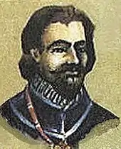
Torres entered the navy of the Spanish Crown at some point and found his way to its South American colonies. By late 160, he first entered the historical record as the nominated commander of the second ship in an expedition to the Pacific proposed by the Portuguese born navigator Pedro Fernandes de Queirós, searching for Terra Australis. There is no known contemporary depiction of his face or person.
The Queirós voyage
Pedro Fernandes de Queirós was a Portuguese-born navigator who commanded a party of three Spanish ships, San Pedro y San Pablo (60 tons), San Pedrico (40 tons) and the tender Los Tres Reyes Magos. The three ships left Callao in Spanish Peru, on 21 December 1605, with Torres in command of the San Pedrico.
In May 1606, they reached a group of islands that would later be known as the New Hebrides and Vanuatu. Queirós named the group La Austrialia del Espiritu Santo: "Austrialia [sic] of the Holy Spirit".[9] A morphological derivation of Austria, Queirós's neologism Austrialia was a reference to the Austrian origins of the House of Habsburg – to which the Spanish royal family belonged.[10] The largest island in Vanuatu is still known officially by the abbreviated form, Espiritu Santo. Along with the ancient Latin name Terra Australis, Queirós's word Austrialia has often been regarded as one of the bases of the name of Australia.
After six weeks, Queirós’ ships put to sea again to explore the coastline. On the night of 11 June 1606 Queirós in the San Pedro y San Pablo became separated from the other ships in bad weather and was unable (or so he later said) to return to safe anchorage at Espiritu Santo. In reality, the crew mutinied, with the unfavorable wind conditions just giving them an opportunity to do so. The captain on the San Pedro y San Pablo named Don Diego de Prado, aware of the crew's plans, had already transferred to Torres' ship, and so did the expedition's surgeon. Queirós' ship, with Queirós being held in his cabin, then sailed to Acapulco in Mexico, where she arrived in November 1606. In the account by Prado, which is highly critical of Queirós, mutiny and poor leadership are given as the reason for Queirós’ disappearance.[11] Torres, in his account, says that whoever was in charge of San Pedro y San Pablo departed intentionally, saying "it was not possible for us to find them, for they did not sail on the proper course, nor with good intention". Later, although Torres' crew was displeased with Torres' decisions, a full-scale mutiny did not happen; Torres says his "condition was different to that of Captain Queirós."[12][13]
Torres assumes command
Torres remained at Espiritu Santo for 15 days before opening sealed orders he had been given by the Viceroy of Peru. These contained instructions on what course to follow if the ships became separated and who would be in command in the event of the loss of Queirós. The orders appear to have listed Prado as successor to Queirós, as he was capitán-entretenido (spare captain) on the voyage.[14] However, there is overwhelming evidence Torres remained in command, including Prado’s own account.[15][16]
The south coast of New Guinea and Torres Strait

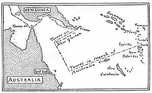
On 26 June 1606 the San Pedrico and Los Tres Reyes Magos under Torres’ command set sail for Manila. Contrary winds prevented the ships taking the more direct route along the north coast of New Guinea. Prado’s account notes that they sighted land on 14 July 1606, which was probably the island of Tagula in the Louisiade Archipelago, south east of New Guinea. The voyage continued over the next two months along the southeastern coast, and a number of landfalls were made to replenish the ships’ food and water. The expedition discovered Milne Bay including Basilaki Island which they named Tierra de San Buenaventura, taking possession of the land for Spain in July 1606.[12] This brought the Spanish in close and sometimes violent contact with local indigenous people. Prado and Torres both record the capture of twenty people, including a woman who gave birth several weeks later.[11] From these islands, Torres sailed along the southern coast of New Guinea reaching Orangerie Bay, which he named Bahía de San Lorenzo because he landed on 10 August, the feast of Saint Lawrence or San Lorenzo. The expedition then sailed to the Gulf of Papua, exploring and charting the coastline. Prado drew a number of sketch charts of anchorages in the Gulf of Papua, several of which survive.[17]
Torres then took a route close to the New Guinea coast to navigate the 150 kilometre strait that now bears his name. In 1980 the Queensland master mariner Captain Brett Hilder proposed that it was more likely that Torres took a southerly route through the nearby channel now called Endeavour Strait, on 2–3 October 1606.[18] From this position, he would certainly have seen Cape York, the northernmost extremity of Australia. According to 19th-century Australian writer George Collingridge, Torres "had discovered Australia without being aware of the fact".[19] However, Willem Janszoon had made several landfalls on the west coast of the Cape York Peninsula 7 to 8 months prior, while Torres never claimed that he had sighted the southern continent. "Here there are very large islands, and more to the south" he wrote.[12]

Torres followed the coastline of New Guinea, and claimed possession of the island in the name of the King of Spain on 18 October 1606. On 27 October he reached the western extremity of New Guinea and then made his way north of Ceram and Misool toward the Halmahera Sea. At the beginning of January 1607 he reached Ternate, part of the Spice Islands. He sailed on 1 May for Manila arriving on 22 May. The expedition proved that New Guinea was not part of the sought-after continent.
Results of the voyage
Torres intended to personally present the captives, weapons and a detailed account to the king on his return to Spain. His short written account of the voyage indicates this.[12] However, it appears there was no interest in Manila in outfitting his voyage back to Spain, and he was told his ships and men were required locally for the King’s service.[20]
On 1st June 1607, two ships arrived in Manila from South America, one being Queirós former flagship San Pedro y San Pablo, now under another name, but with some of her former crewmen still aboard. Learning that Queirós had survived, Torres immediately wrote a report of his voyage to Queirós. Although that account no longer survives, Queirós himself referred to it in some of his many memorials to the king, agitating for another voyage.
The official account was written by Diego de Prado and signed by Torres and other officials in Manila 6 June 1608.[21] Torres, his crew and his captives disappear entirely from the historical record at this point, and their subsequent fate is unknown. Prado returned to Spain, possibly taking one of the captive New Guineans with him.[22] Most documents of Torres's discoveries were not published, but on reaching Spain, filed away in Spanish archives, including Prado’s lengthy account and the accompanying charts.
Some time between 1762 and 1765, written accounts of the Torres expedition were seen by British Admiralty Hydrographer Alexander Dalrymple. Dalrymple provided a sketch map which included the Queirós - Torres voyages to Joseph Banks, who undoubtedly passed this information to James Cook.[23][24]
The original official manuscript account reappeared in the collections of Sir Thomas Phillips during the 19th century. At the sale of some of Phillipps' manuscripts by Sotheby's, London, on 26 June 1919 it was purchased by booksellers Henry Stevens, Son and Stiles who sold it to English collector Sir Leicester Harmsworth. The State Library of New South Wales in Australia acquired it from Harmsworth's collection in 1932.[21] It went on public display for the first time in August 1997.
Accounts of the voyage
There are a number of documents describing the Queirós – Torres voyages still in existence. Most significant are
- Queirós’ many subsequent Memorials to the King Philip III regarding the voyage and further exploration,[25]
- Torres brief account to the king (written July 1607),[12]
- Prado’s narrative Relacion Sumaria (first written in 1608) and 4 charts of New Guinea,[26]
- Juan Luis Arias de Loyola’s memorial to King Philip IV (written about 1630 and based on discussions between Queirós and Loyola).[27]
1617 may be the date of the first English translation of one of Queirós’ memorials, as Terra Australis Incognita, or A New Southerne Discoverie.[28] A short account of Queirós’ voyage and discoveries was published in English by Samuel Purchas in 1625 in Haklvytvs posthumus, or, Pvrchas his Pilgrimes, vol. iv, p. 1422-1432. This account also appears to be based on a letter by Queirós to the King in 1610, the eighth on the matter.[25]
Notes
- Diego de Prado y Tovar - Summary Account of the Discovery started by Pero Fernandes de Quirós and that was Finished by Captain Diego de Prado y Tovar with the assistance of Captain Luis Váez de Tores on the nao San Pedrico until the city of Manila 20 May 1608 for honouring and glorifying the Allmighty (Relación sumaria del del descubrimto. que empeçó Pero Fernandes de Quirós y le acabo El Capitán Don Diego de Prado con Asistencia del Capitán Luis Vaez de Torres en la nao San Pedrico hasta la ciudad de Manila el 2 de mayo de 1608 a horna y gloria del omnipotente. Handwritten by Diego de Prado, certified and signed by all officials of the nao, including Captain Váez de Torres on Manila on 6 June 1608. Original document published electronically by New South Wales State library. Page 1, line 17. "De la nao almiranta San Pedrico será Capitán Don Luis Váez de Torres, bretón" (Of the nao almiranta San Pedrico it will be captain Don Luis Váez de Torres, bretón). Page 1 available (latest access 01/10/2013 at http://acms.sl.nsw.gov.au/album/ItemViewer.aspx?itemid=824242&suppress=N&imgindex=2
- Estensen, M. (2006) Terra Australis Incognita: The Spanish Quest for the mysterious Great South Land, p. 115. Allen & Unwin, Australia. ISBN 978-1-74175-054-6. Estensen notes that Don Diego de Prado y Tovar, a Spanish nobleman who accompanied Torres, refers to him in his account as a "Breton". Estensen points out that Spaniards then colloquially called Galicians Bretons, and that, therefore, Torres was almost certainly from Galicia.
- Hilder, B.(1980) The Voyage of Torres. University of Queensland Press, St. Lucia. 1980, ISBN 0-7022-1275-X
- "The Celtic zones par excellence, however, continued to be Galicia and Portugal." 'A history of Spain from the beginnings to the present day' by Rafael Altamira; translated by Muna Lee, 1966
- Journal of Diego de Prado y Tobar, State Library of New South Wales. ADLIB110326511 Accessed 18/1/2017. For the original account, see page 1 line 17 of the account by Dom Diego de Prado, signed by Captain Vaz de Torres and other officials in Manila on June 6, 1608, also page 10 line 26-28
- Alan Villiers, The Coral Sea, Whittlesey House, 1949, p. 99.: "The second-in-command, or at any rate the commanding officer of the second ship, was a Portuguese pilot named Luis Vaz de Torres".
- William A. R. Richardson, Was Australia charted before 1606? The Java la Grande inscriptions, National Library Australia, 2006, p. 20. ISBN 0-642-27642-0 ISBN 978-0-642-27642-1: "Pedro Fernandes de Quirós and Luis Vaz de Torres, both Portuguese in command of Spanish vessels..."
- Kenneth Gordon McIntyre, The secret discovery of Australia: Portuguese ventures 250 years before Captain Cook, Pan Books, 1987, p. 181. ISBN 0-330-27101-6 ISBN 978-0-330-27101-1:"In these Spanish expeditions to the South Seas, the Portuguese explorers Pedro Fernandes de Queiros and Luis Vaz de Torres played a leading part. ..." - Found in the search results
- With regard to the name Austrialia [sic], see accounts of the voyage cited, e.g. Estensen, M (2006)
- Hilder, B.(1980) The Voyage of Torres. p.17. University of Queensland Press, St. Lucia. ISBN 0-7022-1275-X
- Prado's account can be read online
- Translation of Torres’ report to the king in Collingridge, G. (1895) The Discovery of Australia p.229-237. Golden Press Edition 1983, Gradesville, NSW. ISBN 0-85558-956-6. Full text available online: The Discovery of Australia, chapter 39: Relation of Luis Vaez de Torres
- Brett Hilder notes that there are "at least a dozen (letters in Spanish archives) from various officers denouncing Queirós(as) an incompetent leader." Hilder, B. (1980) p.175
- The claim he assumed command, made by Prado himself, was accepted by some writers in the 1930s, including Stevens, H.N. (Ed) New Light on the Discovery of Australia as Revealed by the Journal of Captain Don Diego de Prado y Tovar. Hakluyt Society, London, 1930
- Hilder, B. (1980) p.17+
- Estensen, M. (2006) p186-189
- For colour photos of the charts, see Hilder, B. (1980). Also see Collingridge’s The First Discovery of Australia and New Guinea, 1905, which includes Collingridge’s own copies of three of the charts . The charts are the coloured maps 5,6 and 9.Map 9 is incorrectly titled "Moresby's Map of the Islands at the South-east end of New Guinea." It is in fact based on Prado’s Mappa III - showing Orangerie Bay, New Guinea
- Hilder, B.(1980) p.89-101
- George Collingridge (1905) The First Discovery of Australia and New Guinea.
- Hilder, B. (1980). p.130
- Hilder, B (1980) p132-133. Prado wrote letters from Goa in December 1613, indicating he had taken the Portuguese route home. Some time afterwards he is described as "a monk of our father Saint Basil the Great of Madrid." Estensen, M. (2006) p.219
- Hilder, B (1980) p.31
- Estensen, M. (2006) p.222
- A copy at the Library of Congress can be read online
- For colour photos of the charts, see Hilder, B. (1980). Also see Collingridge’s The First Discovery of Australia, 1895, which includes Collingridge’s own copies of three of the charts The charts are the coloured maps 5,6 and 9.(Map 9 is incorrectly titled "Moresby's Map of the Islands at the South-east end of New Guinea" . It is in fact based on Prado’s Mappa III - showing Orangerie Bay, New Guinea.),
- Hilder, B (1980) p.175-176
- The La Trobe Library of Victoria lists a copy of this as one of its rare books "Archived copy". Archived from the original on 3 September 2007. Retrieved 9 December 2007.CS1 maint: archived copy as title (link)
External links
- Prado y Tobar - Relacion sumaria del del descubrimto. que enpeco pero fernandez de quiros...y le acabo El capan don diego de prado...con asistencia del capan luis baes de torres...1607, written ca. 1614-1615, catalogue record, contents description and digitised pages 1-32, State Library of New South Wales.
- Discovery of Australia by de Queirós in the Year 1606 by Patrick F. Cardinal Moran, Archbishop of Sydney
- Discoverer’s Website project
- Hakluytus Posthumus - Purchas his Pilgrimes
- The First Discovery of Australia and New Guinea by George Collingridge, Chapter XI
- "New Light on the Discovery of Australia" edited by H Stevens, at Project Gutenberg Australia
