Louisiade Archipelago
The Louisiade Archipelago is a string of ten larger volcanic islands frequently fringed by coral reefs, and 90 smaller coral islands in Papua New Guinea.
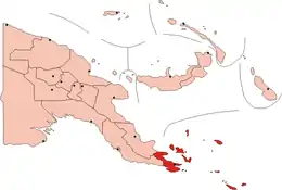 Map of Papua New Guinea The Louisiade Archipelago is in the dark red area at the bottom of the map. | |
| Geography | |
|---|---|
| Coordinates | 11°12′S 153°00′E |
| Total islands | 300+ |
| Area | 1,871.1 km2 (722.4 sq mi) |
| Administration | |
| Province | Milne Bay Province |
| Capital city | Bwagaoia |
| Largest settlement | Bwagaoia (pop. 2680) |
| Demographics | |
| Population | 47000 (2014) |
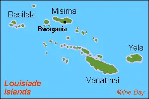
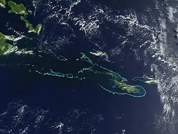
It is located 200 km southeast of New Guinea, stretching over more than 160 kilometres (99 mi) and spread over an ocean area of 26,000 square kilometres (10,000 sq mi) between the Solomon Sea to the north and the Coral Sea to the south. The aggregate land area of the islands is about 1,871 square kilometres (722 sq mi), with Vanatinai (Tagula) being the largest.
Rogeia, Samarai and Sariba lie closest to New Guinea, while Misima, Vanatinai, and Rossel islands lie further east.
History
The islands were discovered by a Spanish expedition led by Luis Váez de Torres in 1606, that was part of the Fernandez de Quiros fleet which had sailed from South America in search of Australia. The Torres expedition visited various islands including Basilaki Island, which he named San Buenaventura in July 1606. It is possible that Malay and Chinese sailors also visited the islands earlier. More than a century later, in 1768, Louis Antoine de Bougainville visited the islands and named them for Louis XV, the king of France. Visits were also paid by Admiral Bruni d'Entrecasteaux in 1793 and Captain Owen Stanley in 1849.
The 1942 Battle of Coral Sea was fought nearby, after Japanese occupation in the same year. The Deboyne Islands were the site of the 1942 Raids on Deboyne.
Rain forests
The islands have a moist tropical climate, and are largely covered with tropical moist broadleaf forests. The Louisiade Archipelago rain forests form a distinct ecoregion, and are home to a number of endemic species, including several endemic trees (in genera Pandanus, Diospyros, and Hopea), as well as five endemic frog species, two endemic lizard species, and five endemic bird species.
Government
The archipelago is divided into the Local Level Government (LLG) areas Bwanabwana Rural (western part, with Basilaki), Louisiade Rural (central part, with Misima), and Yaleyamba (eastern part, with Rossell and Vanatinai islands). The LLG areas are part of Samarai-Murua District of Milne Bay. The seat of the Louisiade Rural LLG is Bwagaoia on Misima Island, the population center of the archipelago.[1] The seat of the Yaleyamba is changed every couple of years between Rambuso and Jingo (Rossell). The seat of the Bwanabwana was Samarai from the Louisiade archipelago, but was recently transferred to the mainland of Papua New Guinea to the city of Alotau.
Islands
The Louisiade Archipelago consists of the following island groups and islands:[2]
| Island | Capital | Other Cities | Area (km²) | Population |
|---|---|---|---|---|
| Bentley Islands | Anagusa | Nare | 2.49 | 122 |
| Anagusa | Anagusa | 1.42 | 112 | |
| Mudge | Nare | 1.07 | 10 | |
| Bonvouloir Islands | 5.54 | 0 | ||
| East | 2.93 | 0 | ||
| Hastings | 1.26 | 0 | ||
| Strathord | 1.35 | 0 | ||
| Calvados Chain | Pana Wina | Motorina, Bagaman, Hemenahei | 85.1 | 3276 |
| Bagaman | Bagaman | 7.45 | 264 | |
| Bobo Eina | 2.43 | 0 | ||
| Bonna Wan | 1.09 | 0 | ||
| Gigila | Nogui | 1.42 | 121 | |
| Gilia | 0.36 | 0 | ||
| Gulewa | Gulewa | 0.59 | 18 | |
| Hemenahei | 10.15 | 0 | ||
| Kuwanak | Kuwanak | 3.66 | 170 | |
| Mabneian | 0.38 | 0 | ||
| Motorina | Riman Bay | Tawara, Mabaraboraboa | 7.8 | 595 |
| Nigaho | Nigaho | 0.1 | 226 | |
| North Leiga | 0.05 | 0 | ||
| Other | Burnett | Ehiki, Panua Keikeisa | 1.78 | 0 |
| Pana Krusima | 1.47 | 0 | ||
| Pana Numara | Hoba Bay | 1.93 | 183 | |
| Pana Rora | 0.81 | 0 | ||
| Pana Udu Udi | 0.69 | 0 | ||
| Pana Varavara | 0.57 | 0 | ||
| Pana Wina | Bomalou | Panambari, Boiama Point | 30.55 | 456 |
| Panangaribu | 0.5 | 0 | ||
| Panasia | 2.11 | 0 | ||
| Panatanian | 0.79 | 0 | ||
| Sabari | Hekampan | Tandeyai, Hebenahine, Maho | 4.04 | 708 |
| Sloss | 0.36 | 0 | ||
| South Leiga | 0.05 | 0 | ||
| Taifaur | 0.4 | 0 | ||
| Ululina | Ululina | 0.59 | 5 | |
| Utian | Utian | 1.54 | 514 | |
| Venariwa | Venariwa | 0.76 | 16 | |
| Yakimoan | 0.31 | 0 | ||
| Yaruman | 0.37 | 0 | ||
| Conflict Group | Panasesa | Irai, Lunn | 5.06 | 30 |
| Auriroa | 0.76 | 0 | ||
| Gabugabutau | 0.12 | 0 | ||
| Ginara | 0.14 | 0 | ||
| Irai | Irai | 1.08 | 20 | |
| Itamarina | 0.04 | 0 | ||
| Lunn | 0.51 | 0 | ||
| Moniara | 0.2 | 0 | ||
| Other | Kolavia | Madiboiboi, Lutmatavi | 0.4 | 0 |
| Panaboal | 0.52 | 0 | ||
| Panarakuum | 0.51 | 0 | ||
| Panasesa | Panasesa | 0.68 | 10 | |
| Quesal | 0.08 | 0 | ||
| Tupit | 0.02 | 0 | ||
| Deboyne Islands | Bwaganati | Nulia | 41.9 | 2700 |
| Losai | 0.01 | 0 | ||
| Nibub | 0.02 | 0 | ||
| Nivani | Nivani | 0.5 | 20 | |
| Pana Uya Wana | 0.36 | 0 | ||
| Panaeati | Bwaganati | Maggiau, Palualual, Siakeu, Namati, Panakakamwa, Nulia Wharf, Lebwalebwal | 30.32 | 2080 |
| Panapompom | Nulia | Galowawaisana, Panaewau | 7.72 | 600 |
| Passage | 0.06 | 0 | ||
| Rara | 0.14 | 0 | ||
| Duchateau Islands | 2.58 | 0 | ||
| Jomard Islands | 0.96 | 0 | ||
| Kukuluba | 0.32 | 0 | ||
| Montemont Islands | 0.12 | 0 | ||
| Pana Bobai Ana | 0.75 | 0 | ||
| Pana Rura Wara | 0.42 | 0 | ||
| Dumoulin Islands | 0.66 | 0 | ||
| Ana Karu Karua | 0.2 | 0 | ||
| Baiiri | 0.34 | 0 | ||
| Duperre Islands | Punawan | 0.82 | 10 | |
| Duperre | 0.15 | 0 | ||
| Punawan | Punawan | 0.43 | 10 | |
| East Deboyne Islands | 1.02 | 0 | ||
| Basses Group | 0.515 | 0 | ||
| Bushy Islets | 0.105 | 0 | ||
| Mabui | 0.027 | 0 | ||
| Pana Sagusagu | 0.172 | 0 | ||
| Redlick Islets | 0.2 | 0 | ||
| Engineer Islands | Skelton | Watts | 11.12 | 1200 |
| Bright | 0.07 | 0 | ||
| Butchart | 0.09 | 0 | ||
| Button | 0.07 | 0 | ||
| Deedes | 0.11 | 0 | ||
| Flat | 0.03 | 0 | ||
| Good | 0.32 | 0 | ||
| Haszard | 0.72 | 0 | ||
| Hummock | Tewatewa | 0.61 | 105 | |
| Messum | 0.06 | 0 | ||
| Pender | 0.12 | 0 | ||
| Powell | 0.15 | 0 | ||
| Skelton | Naruaruari | Koialia, Waiaku, Digaigaia | 3.56 | 375 |
| Slade | Samoa | Tubetube | 2.61 | 245 |
| Watts | Gegadali | Taeaknabululu, Kwaraiwa | 2.56 | 475 |
| Laseinie Islands | Dawson | 2 | 245 | |
| Dawson | Koyagaugau | 1.36 | 245 | |
| Hardman | 0.25 | 0 | ||
| Kagawan | 0.05 | 0 | ||
| Keaawan | 0.3 | 0 | ||
| Misima Islands | Bwagaoia | 215 | 19330 | |
| Gigira | 0.03 | 0 | ||
| Managun | 0.26 | 0 | ||
| Misima | Bwagaoia | Baimatana, Hinauta, Kaubwaga, Boiou, Siagara, Kalotawa, Gulewa, Mwana, Liak, Panataval, Bagilina, Manihuna, Ewena, Ebora, Bwagabwaga, Alhoga, Eaus, Gaibobo, Narian | 214.5 | 19330 |
| Daloloia Group | 0.13 | 0 | ||
| Pana Tinani Islands | Bwailahina | Kabagi-bagi | 99.92 | 1764 |
| Daddahai | Dadahai | 0.258 | 34 | |
| Hevaisi | 0.234 | 1 | ||
| Nimoa | Soluwo | Boiminusi, Woos, Galanga Beach | 3.556 | 395 |
| Osasai | 0.133 | 0 | ||
| Pana Tinani | Bwailahina | Hobuk, Hauagili, Hessessai Bay, Buvara Bay, Bounce Point, Imadi Bay, Gawn Point, Hati Lawi Bay, Heihuti Bay, Bonawi Point | 78 | 527 |
| Sibumbum | 0.01 | 0 | ||
| Wanim | Bunbun | 1.66 | 400 | |
| Yeina | Kabagi-bagi | Araeda, Buwo, Jolandan | 16 | 407 |
| Renard Islands | Kimuta | 4.3 | 617 | |
| Baiwa | 0.17 | 0 | ||
| Kimuta | Awa | Atuatua | 2.86 | 617 |
| Manuga Reef | 0.02 | 0 | ||
| Niva Beno | 0.49 | 0 | ||
| Oreia | 0.47 | 0 | ||
| Rossel Islands | Rossel | 293.8 | 5100 | |
| Adele Islet | 0.18 | 0 | ||
| Diama | 0.06 | 1 | ||
| Other | Heron | 0.02 | 7 | |
| Pocklington Reef | 0.01 | 0 | ||
| Rossel | Jinjo | Damunu, Yonga Bay, Mbuwo, Morpa, Wulunga Bay, Pum, Pwepwo, Piniga, Abeleti, Vyukwa, N’Jaru, Wale, Saman, Pambwa | 292.5 | 5000 |
| Wule | Wule | 1.03 | 92 | |
| Samarai Islands | Samarai | Basilaki | 262.1 | 8200 |
| Arch Islands | Nasa Rua Rua | 0.5 | 0 | |
| Doini | Doini | 4.07 | 30 | |
| Tuyam | 0.16 | 0 | ||
| Gonubalabala | Ranger station | 0.26 | 0 | |
| Logea | Kasabanalua | Kumikuku, Dabali, Pota | 9.02 | 1004 |
| Deka Deka | 0.04 | 0 | ||
| Bonarua Hili Hili | 0.05 | 0 | ||
| Kwato | Kwato | Isuhina | 0.35 | 66 |
| Samarai | Samarai | 0.29 | 460 | |
| Ebuma | Evennett Mansion | 0.022 | 1 | |
| Gesila | 0.17 | 19 | ||
| Dagadaga | 0.07 | 1 | ||
| Kwai Ama | 0.03 | 0 | ||
| Beika | 0.02 | 0 | ||
| Galahi | Galahi | 0.92 | 20 | |
| Lesimano | 0.21 | 0 | ||
| Igwali | Igwali | Naba Riaria, Ga-Uri | 1.47 | 10 |
| Kui | Kui | 0.19 | 5 | |
| Ito | 3.06 | 10 | ||
| Sariba | Sidudu | Sauasauaga, Magehau, Sebuluna | 23.21 | 1880 |
| Sideia | Sideia | Oba, Gotai, Gadogadowa, Sekuku, Dulauna, Tegerauna | 101.3 | 1890 |
| Populai | Margaret Ville | 1.71 | 15 | |
| Dinana | 0.9 | 0 | ||
| Buiari | Weitoa | 3.12 | 500 | |
| Basilaki | Yokowa | Habani | 106 | 1883 |
| Kitai Bai | 0.11 | 0 | ||
| Kitai Katoa | Maragum | 0.55 | 17 | |
| Kitai Katu | 0.72 | 10 | ||
| Kitai Lilivea | 3 | 190 | ||
| Kitai Bona Bona | Kibou | 0.42 | 10 | |
| Castori Islets | Baia Baia Karona | 0.18 | 0 | |
| Gado-Gadoa | 0.15 | 1 | ||
| Wasima | 0.05 | 0 | ||
| Other | Sripkunui Island, Nasariri Island, Didigilo Island, Grant Island, Shortland Island | 0.8 | 0 | |
| Torlesse Islands | 2.08 | 0 | ||
| Pananiu | 0.86 | 0 | ||
| Tinolan | 0.8 | 0 | ||
| Vanatinai Islands | Rambuso | Tagula, Donuwo, Bololo | 831.6 | 3360 |
| Boboa | 0.07 | 0 | ||
| Iyen | Iyen | 0.86 | 102 | |
| Pana Man | 0.12 | 0 | ||
| Vanatinai | Rambuso | Tagula, Eden, Mitin, Edwahi, Griffin Point, Tarangia, Lajamare, Donuwo, Siri Point, Buiawe, Bololo, Emeli, Pamela, Madaua, Jelewaga | 830 | 3257 |
| Venama | 0.55 | 0 | ||
| Wari Islands | Wari | 3.85 | 926 | |
| Imbert | 0.22 | 0 | ||
| Kosman Reef | Kosman | Nabaina | 0.17 | 100 |
| Lebrun Islands | 0.22 | 0 | ||
| Long Reef | Lejeune | 0.03 | 100 | |
| Other | 0.15 | 0 | ||
| Quessant | 0.41 | 0 | ||
| Sable | 0.03 | 0 | ||
| Siga | 0.01 | 0 | ||
| Stuers Islands | 0.34 | 0 | ||
| Wari | Wari | 2.27 | 726 | |
| Louisiade Archipelago | Bwagaoia | Samarai, Rossel | 1871.1 | 47000 |
References
- http://www.pngec.gov.pg/ElectionInfo2007/PollSched-MilneBay.pdf%5B%5D
- "Archived copy". Archived from the original on 2006-01-02. Retrieved 2006-01-02.CS1 maint: archived copy as title (link)
External links
| Wikimedia Commons has media related to Louisiade Archipelago. |
- . Encyclopædia Britannica. 17 (11th ed.). 1911.
- "Louisiade Archipelago rain forests". Terrestrial Ecoregions. World Wildlife Fund.
- Milne Bay Province Polling list with place names (2007)
- Eusoils.jrc.it: detailed geology/soils map (1:1.000.000)
- Louisiades.net: Information and advice for yachts and travellers visiting the Louisiade Archipelago islands
| Authority control |
|
|---|