Lushton, Nebraska
Lushton is a village in York County, Nebraska, United States. The population was 30 at the 2010 census.
Lushton, Nebraska | |
|---|---|
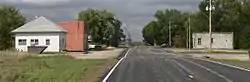 Downtown Lushton: Gilbert Street | |
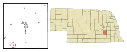 Location of Lushton, Nebraska | |
| Coordinates: 40°43′26″N 97°43′28″W | |
| Country | United States |
| State | Nebraska |
| County | York |
| Area | |
| • Total | 0.14 sq mi (0.37 km2) |
| • Land | 0.14 sq mi (0.37 km2) |
| • Water | 0.00 sq mi (0.00 km2) |
| Elevation | 1,677 ft (511 m) |
| Population | |
| • Total | 30 |
| • Estimate (2019)[3] | 29 |
| • Density | 204.23/sq mi (78.62/km2) |
| Time zone | UTC-6 (Central (CST)) |
| • Summer (DST) | UTC-5 (CDT) |
| ZIP code | 68371 |
| Area code(s) | 402 |
| FIPS code | 31-29645[4] |
| GNIS feature ID | 0830954[5] |
History
Lushton was laid out and platted in 1887 when the Kansas City & Omaha Railroad was extended to that point.[6][7] It was named for a railroad official.[8]
A post office was established in Lushton in 1887, and remained in operation until it was discontinued in 1965.[9]
Geography
Lushton is located at 40°43′26″N 97°43′28″W (40.723807, -97.724476).[10]
According to the United States Census Bureau, the village has a total area of 0.14 square miles (0.36 km2), all land.[11]
Demographics
| Historical population | |||
|---|---|---|---|
| Census | Pop. | %± | |
| 1910 | 205 | — | |
| 1920 | 186 | −9.3% | |
| 1930 | 148 | −20.4% | |
| 1940 | 126 | −14.9% | |
| 1950 | 60 | −52.4% | |
| 1960 | 45 | −25.0% | |
| 1970 | 34 | −24.4% | |
| 1980 | 33 | −2.9% | |
| 1990 | 28 | −15.2% | |
| 2000 | 33 | 17.9% | |
| 2010 | 30 | −9.1% | |
| 2019 (est.) | 29 | [3] | −3.3% |
| U.S. Decennial Census[12] | |||
2010 census
As of the census[2] of 2010, there were 30 people, 15 households, and 10 families residing in the village. The population density was 214.3 inhabitants per square mile (82.7/km2). There were 18 housing units at an average density of 128.6 per square mile (49.7/km2). The racial makeup of the village was 100.0% White.
There were 15 households, of which 13.3% had children under the age of 18 living with them, 60.0% were married couples living together, 6.7% had a female householder with no husband present, and 33.3% were non-families. 33.3% of all households were made up of individuals, and 6.7% had someone living alone who was 65 years of age or older. The average household size was 2.00 and the average family size was 2.50.
The median age in the village was 51 years. 13.3% of residents were under the age of 18; 0.1% were between the ages of 18 and 24; 23.4% were from 25 to 44; 26.6% were from 45 to 64; and 36.7% were 65 years of age or older. The gender makeup of the village was 56.7% male and 43.3% female.
2000 census
As of the census[4] of 2000, there were 33 people, 16 households, and 12 families residing in the village. The population density was 232.9 people per square mile (91.0/km2). There were 17 housing units at an average density of 120.0 per square mile (46.9/km2). The racial makeup of the village was 100.00% White.
There were 16 households, out of which 6.3% had children under the age of 18 living with them, 62.5% were married couples living together, 6.3% had a female householder with no husband present, and 25.0% were non-families. 25.0% of all households were made up of individuals, and 6.3% had someone living alone who was 65 years of age or older. The average household size was 2.06 and the average family size was 2.42.
In the village, the population was spread out, with 12.1% under the age of 18, 21.2% from 25 to 44, 48.5% from 45 to 64, and 18.2% who were 65 years of age or older. The median age was 56 years. For every 100 females, there were 120.0 males. For every 100 females age 18 and over, there were 93.3 males.
As of 2000 the median income for a household in the village was $31,250, and the median income for a family was $43,750. Males had a median income of $22,500 versus $22,500 for females. The per capita income for the village was $17,726. None of the population and none of the families were below the poverty line.
References
- "2019 U.S. Gazetteer Files". United States Census Bureau. Retrieved July 26, 2020.
- "U.S. Census website". United States Census Bureau. Retrieved 2012-06-24.
- "Population and Housing Unit Estimates". United States Census Bureau. May 24, 2020. Retrieved May 27, 2020.
- "U.S. Census website". United States Census Bureau. Retrieved 2008-01-31.
- "US Board on Geographic Names". United States Geological Survey. 2007-10-25. Retrieved 2008-01-31.
- Burr, George L. (1921). History of Hamilton and Clay Counties, Nebraska, Volume 1. S.J. Clarke Publishing Company. p. 142.
- "Lushton, York County". Center for Advanced Land Management Information Technologies. University of Nebraska. Retrieved 24 August 2014.
- Fitzpatrick, Lillian L. (1960). Nebraska Place-Names. University of Nebraska Press. p. 147. ISBN 0-8032-5060-6. A 1925 edition is available for download at University of Nebraska—Lincoln Digital Commons.
- "York County". Jim Forte Postal History. Retrieved 24 August 2014.
- "US Gazetteer files: 2010, 2000, and 1990". United States Census Bureau. 2011-02-12. Retrieved 2011-04-23.
- "US Gazetteer files 2010". United States Census Bureau. Archived from the original on 2012-01-25. Retrieved 2012-06-24.
- "Census of Population and Housing". Census.gov. Retrieved June 4, 2015.
External links
Municipalities and communities of York County, Nebraska, United States | ||
|---|---|---|
| Cities | Map of Nebraska highlighting York County | |
| Villages | ||
| Unincorporated communities | ||
| Ghost towns | ||
| ||