Märkisch-Oderland
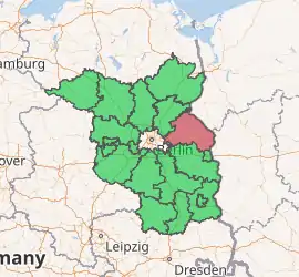
Märkisch-Oderland is a Landkreis (district) in the eastern part of Brandenburg, Germany. Neighboring are (from the north clockwise) the district Barnim, the country Poland, the district-free city Frankfurt (Oder), the district Oder-Spree and the Bundesland Berlin. The administrative seat is Seelow but the largest town is Strausberg.
Märkisch-Oderland | |
|---|---|
 Coat of arms | |
| |
| Country | Germany |
| State | Brandenburg |
| Capital | Seelow |
| Area | |
| • Total | 2,127.7 km2 (821.5 sq mi) |
| Population (31 December 2019)[1] | |
| • Total | 195,751 |
| • Density | 92/km2 (240/sq mi) |
| Time zone | UTC+01:00 (CET) |
| • Summer (DST) | UTC+02:00 (CEST) |
| Vehicle registration | MOL (former: FRW, SEE, SRB) |
| Website | maerkisch-oderland.de |
Geography
The district extends from the outskirts of Berlin in the west to the Oder river and the Polish border in the east. It includes a swampy area along the Oder known as the Oderbruch, about 60 km in length and 17 km in width. The Oderbruch was partially drained and populated in the 18th century. The rest of the district is mainly agricultural land.
History
The district dates back to the district Lebus and the district Oberbarnim, which were both created in 1816. The district Lebus dates back to the Land Lebus, the region around the town of Lebus. In 1863 Seelow became the seat of the administration of the district Lebus, and in 1950 the district was renamed to Kreis Seelow. In 1952 the districts were split into three parts, the districts Bad Freienwalde, Seelow and Strausberg. In 1993 the three parts were merged to form the current district - the new name refers to Northmarch lands at the Oder river.
Demography
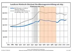 Development of Population since 1875 within the Current Boundaries (Blue Line: Population; Dotted Line: Comparison to Population Development of Brandenburg state)
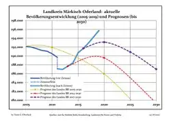 Recent Population Development and Projections (Population Development before Census 2011 (blue line); Recent Population Development according to the Census in Germany in 2011 (blue bordered line); Official projections for 2005-2030 (yellow line); for 2014-2030 (red line); for 2017-2030 (scarlet line)
|
|
|
Coat of arms
The coat of arms shows the eagle of Brandenburg in the upper half. The upper half also resembles the coat of arms of the former district Oberbarnim. In the lower half are two boat-hooks and a star, both taken from the coat of arms of the former district Seelow. The wavy line in the bottom represents the Oder river.
Towns and municipalities
| Amt-free towns | Ämter | |
|---|---|---|
|
Amt-free municipalities
|
1. Amt Barnim-Oderbruch 3. Amt Golzow 4. Amt Lebus |
7. Amt Seelow-Land |
| 1seat of the Amt; 2town | ||
References
- "Bevölkerung im Land Brandenburg nach amtsfreien Gemeinden, Ämtern und Gemeinden 31. Dezember 2019". Amt für Statistik Berlin-Brandenburg (in German). July 2020.
- Detailed data sources are to be found in the Wikimedia Commons.Population Projection Brandenburg at Wikimedia Commons
External links
| Wikimedia Commons has media related to Märkisch-Oderland. |
- (in German) Märkisch-Oderland official website
- (in German) History and infos about Märkisch-Oderland
| Urban districts | |
|---|---|
| Rural districts | |
| Authority control |
|---|