Elbe-Elster
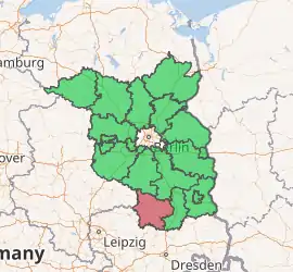
Elbe-Elster is a Kreis (district) in the southern part of Brandenburg, Germany. Neighboring districts are Teltow-Fläming, Dahme-Spreewald, Oberspreewald-Lausitz, Meißen, Nordsachsen and Wittenberg. The district has a partnership with the Märkischer Kreis.
Elbe-Elster | |
|---|---|

| |
| Country | Germany |
| State | Brandenburg |
| Capital | Herzberg |
| Area | |
| • Total | 1,889.4 km2 (729.5 sq mi) |
| Population (31 December 2019)[1] | |
| • Total | 101,827 |
| • Density | 54/km2 (140/sq mi) |
| Time zone | UTC+01:00 (CET) |
| • Summer (DST) | UTC+02:00 (CEST) |
| Vehicle registration | EE, FI, LIB |
| Website | landkreis-elbe-elster.de |
History
The district was established in 1993 by merging the former districts (Kreise) of Finsterwalde, Bad Liebenwerda and Herzberg.
Geography
The district is named after two rivers - the Elbe river forms the western border with Saxony, the Black Elster (Schwarze Elster) is a tributary of the Elbe and runs through the district. The district is part of the Lusatia region. The fens along the Black Elster are a habitat of several rare animals, like common kingfishers, beavers and Eurasian otters.
Demography
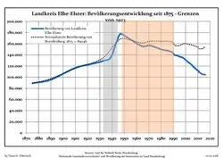
 Development of Population since 1875 within the Current Boundaries (Blue Line: Population; Dotted Line: Comparison to Population Development of Brandenburg state)
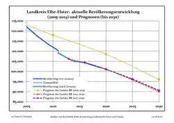
 Recent Population Development and Projections (Population Development before Census 2011 (blue line); Recent Population Development according to the Census in Germany in 2011 (blue bordered line); Official projections for 2005-2030 (yellow line); for 2014-2030 (red line); for 2017-2030 (scarlet line)
|
|
|
Coat of arms
 |
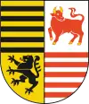
The coat of arms was granted in 1995. The lion in the bottom left derives from the county of Meissen (see Saxony), to which the southern area of the district belonged historically. The black bars derive from the Saxony-Wittenberg county as the area around Bad Liebenwerda belonged there in the past. The red bars derive from the oldest coat of arms of Brandenburg, and the bull is the symbol for the Lower Lusatia area were the district is located. |
Towns and municipalities
| Amt-free towns | Ämter | Verbandsgemeinde | |
|---|---|---|---|
|
|
1. Elsterland 2. Kleine Elster (Niederlausitz) 3. Plessa |
4. Schlieben 5. Schradenland |
1. Liebenwerda |
| 1seat of the Amt; 2town | |||
References
- "Bevölkerung im Land Brandenburg nach amtsfreien Gemeinden, Ämtern und Gemeinden 31. Dezember 2019". Amt für Statistik Berlin-Brandenburg (in German). July 2020.
- Detailed data sources are to be found in the Wikimedia Commons.Population Projection Brandenburg at Wikimedia Commons
External links
| Wikimedia Commons has media related to Elbe-Elster. |
- Official Website (German)
- Touristic website
