Målilla
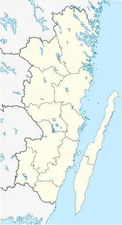
Målilla (Swedish pronunciation: [ˈmôːˌlɪlːa])[2] is a locality situated in Hultsfred Municipality, Kalmar County, Sweden with 1,524 inhabitants in 2010.[1]
Målilla | |
|---|---|
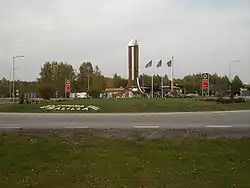 Målilla roundabout, here in October 2005, has a huge thermometer in its centre | |
 Målilla  Målilla | |
| Coordinates: 57°23′N 15°48′E | |
| Country | Sweden |
| Province | Småland |
| County | Kalmar County |
| Municipality | Hultsfred Municipality |
| Area | |
| • Total | 3.26 km2 (1.26 sq mi) |
| Population (31 December 2010)[1] | |
| • Total | 1,524 |
| • Density | 468/km2 (1,210/sq mi) |
| Time zone | UTC+1 (CET) |
| • Summer (DST) | UTC+2 (CEST) |
It is more commonly known as the temperature capital of Sweden due to the frequent records, both high and low, being set there. A Swedish record high temperature of +38°C (100.4°F) was set on June 29, 1947. This record is shared with Ultuna in Uppland. The lowest temperature recorded is −33.8 °C, one of the lowest ever recorded in southern Sweden.
Being famous for the extremes in temperature, visitors are welcomed by a 15 metre high thermometer in the middle of the town's only roundabout. Shortly after its inauguration in December 2000, it was hit by a car and the bulb had to be replaced.
Målilla is further famous for motorcycle speedway. Almost since the birth of the sport the local team has been amongst the best in Sweden. Dackarna Målilla, the original name of the team has lately changed names due to sponsorship deals. Luxo Stars and Team Svelux were two passing names until the original name once again was reinstated.
The other two things which has put Målilla on the Swedish map is their bandy team Målilla Bandy which has had quite big success during the years and adventurer and mountaineer Janne Corax who is the only Swedish alpinist with first ascents in the Himalayas on the CV.
Climate
Målilla has a humid continental climate for the reference period of 1961–1990 with a January and February mean of −3 °C (27 °F).[3] The data from recent years shows the climate moving towards that oceanic, though still continental overall with significant differences between seasons. Whilst winter temperatures have been too cold to be oceanic, summers have become warmer on average. The 2002–2014 July average high was 23.4 °C (74.1 °F), although the temperature record of 38 °C (100 °F) was not attained during this period. The highest temperature recorded since the all-time record-high temperature has been the 36.2 °C (97.2 °F) measured in August 1992 according to SMHI's data series.
Despite being prone to temperature extremes, Målilla has a relatively normal average climate for the southern parts of the country with slightly warmer days and colder nights than typical for the parallel, especially during spring, with April high temperatures averaging 13 °C (55 °F) for 2002–2014, but with night time lows being around the freezing mark.[4] Other official statistical records include exceeding 20 °C (68 °F) in March, attaining 28.8 °C (83.8 °F) in April, and reaching 23 °C (73 °F) in October, all exceptionally warm by Swedish standards. In spite of this, the tied Swedish record of 38 °C (100 °F) set in June 1947 is the only national monthly record currently held by Målilla.[5]
| Climate data for Målilla 2002–2018 (Extremes since 1946) | |||||||||||||
|---|---|---|---|---|---|---|---|---|---|---|---|---|---|
| Month | Jan | Feb | Mar | Apr | May | Jun | Jul | Aug | Sep | Oct | Nov | Dec | Year |
| Record high °C (°F) | 11.0 (51.8) |
16.2 (61.2) |
20.9 (69.6) |
28.8 (83.8) |
30.2 (86.4) |
38.0 (100.4) |
35.0 (95.0) |
36.2 (97.2) |
29.0 (84.2) |
24.0 (75.2) |
15.7 (60.3) |
13.2 (55.8) |
38.0 (100.4) |
| Mean maximum °C (°F) | 7.4 (45.3) |
8.4 (47.1) |
15.3 (59.5) |
20.7 (69.3) |
25.6 (78.1) |
28.5 (83.3) |
29.9 (85.8) |
28.6 (83.5) |
23.9 (75.0) |
17.4 (63.3) |
12.0 (53.6) |
8.5 (47.3) |
31.0 (87.8) |
| Average high °C (°F) | 0.9 (33.6) |
1.9 (35.4) |
6.4 (43.5) |
12.8 (55.0) |
18.0 (64.4) |
21.4 (70.5) |
23.6 (74.5) |
22.2 (72.0) |
17.9 (64.2) |
11.0 (51.8) |
5.9 (42.6) |
2.6 (36.7) |
12.0 (53.7) |
| Average low °C (°F) | −5.0 (23.0) |
−4.9 (23.2) |
−3.6 (25.5) |
0.1 (32.2) |
4.3 (39.7) |
8.1 (46.6) |
11.2 (52.2) |
10.2 (50.4) |
7.0 (44.6) |
2.9 (37.2) |
0.3 (32.5) |
−2.9 (26.8) |
2.3 (36.2) |
| Mean minimum °C (°F) | −18.1 (−0.6) |
−16.6 (2.1) |
−13.5 (7.7) |
−7.3 (18.9) |
−2.8 (27.0) |
1.3 (34.3) |
5.4 (41.7) |
2.9 (37.2) |
−0.6 (30.9) |
−5.8 (21.6) |
−9.0 (15.8) |
−13.6 (7.5) |
−21.4 (−6.5) |
| Record low °C (°F) | −27.2 (−17.0) |
−33.8 (−28.8) |
−28.5 (−19.3) |
−13.7 (7.3) |
−7.2 (19.0) |
−3.2 (26.2) |
0.9 (33.6) |
−1.5 (29.3) |
−8.0 (17.6) |
−12.8 (9.0) |
−22.8 (−9.0) |
−27.0 (−16.6) |
−33.8 (−28.8) |
| Average precipitation mm (inches) | 35.4 (1.39) |
29.2 (1.15) |
25.2 (0.99) |
24.6 (0.97) |
43.1 (1.70) |
67.4 (2.65) |
93.2 (3.67) |
72.4 (2.85) |
35.6 (1.40) |
53.5 (2.11) |
47.9 (1.89) |
36.8 (1.45) |
564.3 (22.22) |
| Source 1: SMHI Open Data[6] | |||||||||||||
| Source 2: SMHI Monthly Data 2002–2018[7] | |||||||||||||
References
- "Tätorternas landareal, folkmängd och invånare per km2 2005 och 2010" (in Swedish). Statistics Sweden. 14 December 2011. Archived from the original on 10 January 2012. Retrieved 10 January 2012.
- Jöran Sahlgren; Gösta Bergman (1979). Svenska ortnamn med uttalsuppgifter (in Swedish). p. 17.
- "Temperature Normals 1961–1990". SMHI. Retrieved 15 March 2015.
- "Yearly and Monthly Statistics". SMHI. Retrieved 15 March 2015.
- "Swedish Temperature Records". SMHI. Retrieved 15 March 2015.
- "Precitipation Normals 1961–1990" (in Swedish). Swedish Meteorological and Hydrological Institute.
- "Yearly and Monthly Statistics" (in Swedish). Swedish Meteorological and Hydrological Institute. 8 April 2019.
