Mühlhausen im Täle
Mühlhausen im Täle is a municipality of the district of Göppingen in Baden-Württemberg, Germany.
Mühlhausen im Täle | |
|---|---|
 View of Mühlhausen from the A8 | |
 Coat of arms | |
Location of Mühlhausen im Täle within Göppingen district 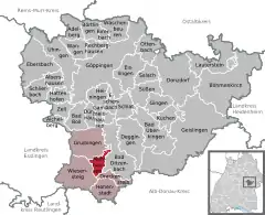 | |
 Mühlhausen im Täle  Mühlhausen im Täle | |
| Coordinates: 48°34′44″N 9°39′30″E | |
| Country | Germany |
| State | Baden-Württemberg |
| Admin. region | Stuttgart |
| District | Göppingen |
| Area | |
| • Total | 6.33 km2 (2.44 sq mi) |
| Elevation | 545 m (1,788 ft) |
| Population (2019-12-31)[1] | |
| • Total | 1,080 |
| • Density | 170/km2 (440/sq mi) |
| Time zone | UTC+01:00 (CET) |
| • Summer (DST) | UTC+02:00 (CEST) |
| Postal codes | 73347 |
| Dialling codes | 07335 |
| Vehicle registration | GP |
| Website | www |
History
Mühlhausen im Täle was first mentioned in 812. In the 12th century, it became a possession of the County of Helfenstein, who ruled the area until it was mediatized to the Kingdom of Württemberg in 1806. Mühlhausen was first placed under the jurisdiction of Wiesensteig but in 1809 was assigned to Oberamt Geislingen. In 1938, the town was assigned to the district of Göppingen. Mühlhausen grew extensively after World War II. Its municipal name was changed from Mühlhausen to Mühlhausen im Täle in 1959.[2]
Geography
The municipality (Gemeinde) of Mühlhausen im Täle is found in the south of the district of Göppingen, in the German state of Baden-Württemberg. Mühlhausen is physically located in the upper valley of the Fils, in the Middle Kuppenalb. Elevation above sea level in the municipal area ranges from a high of 820 meters (2,690 ft) Normalnull (NN) to a low of 531 meters (1,742 ft) NN.[2]
Portions of the Federally-protected Rufsteinhänge und Umgebung and Sterneck nature reserves are located in Mühlhausen's municipal area.[2]
Politics
The municipality of Mühlhausen im Täle includes the villages of Eselhöfe, Exenmühle, and Todsburg. Along with the municipalities of Wiesensteig, Drackenstein, Gruibingen, and Hohenstadt, Mühlhausen has since 1972 been a member of the Upper Fils Valley governmental association. Mühlhausen is also a member of the local school association and sewage association.[2]
Coat of arms
Mühlhausen's coat of arms displays a cuckoo bird in white upon a field of red. The cuckoo bird is a reference to a local nickname for Mühlhausen's inhabitants and the tincture is taken from the arms of the House of Rechberg. This pattern was first adopted by the municipal council in 1930 and was approved for official use and a corresponding municipal flag issued by the Federal Ministry of the Interior on 19 February 1959.[2]
Transportation
Mühlhausen is connected to Germany's network of roadways by Bundesautobahn 8 and Bundesstraße 466. From 1903 to 1968, it was connected to Germany's railway system by the Tälesbahn railroad. Local public transportation is provided by the Filsland Mobilitätsverbund.[2]
References
- "Bevölkerung nach Nationalität und Geschlecht am 31. Dezember 2019". Statistisches Landesamt Baden-Württemberg (in German). September 2020.
- "Mühlhausen im Täle". LEO-BW (in German). Baden-Württemberg. Retrieved 27 July 2020.
External links
| Wikimedia Commons has media related to Mühlhausen im Täle. |
- Official website
 (in German)
| Authority control |
|---|