Magog, Quebec
Magog (locally /ˈmeɪɡɔːɡ/; [maˈɡɔɡ]) is a city in southeastern Quebec, Canada, about 120 kilometres (75 mi) east of Montreal at the confluence of Lake Memphremagog—after which the city was named—with the Rivière aux Cerises and the Magog River. It is a major centre and industrial city in the Regional County Municipality of Memphremagog. The city lies in the Eastern Townships tourist region.
Magog | |
|---|---|
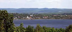 The skyline of the city of Magog | |
 | |
| Motto(s): Fidelitate et Labore(Latin) "Through faithfulness and labour" | |
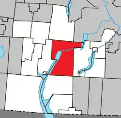 Location within Memphrémagog RCM | |
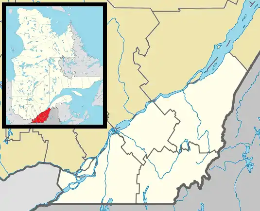 Magog Location in southern Quebec | |
| Coordinates: 45°16′N 72°09′W[1] | |
| Country | Canada |
| Province | Quebec |
| Region | Estrie |
| RCM | Memphrémagog |
| Constituted | October 9, 2002 |
| Government | |
| • Mayor | Vicki May Hamm |
| • Federal riding | Brome—Missisquoi |
| • Prov. riding | Orford |
| Area | |
| • Total | 167.50 km2 (64.67 sq mi) |
| • Land | 144.19 km2 (55.67 sq mi) |
| Population (2011)[4] | |
| • Total | 25,358 |
| • Density | 175.9/km2 (456/sq mi) |
| • Pop 2006-2011 | |
| • Dwellings | 13,605 |
| Time zone | UTC−5 (EST) |
| • Summer (DST) | UTC−4 (EDT) |
| Postal code(s) | J1X |
| Area code(s) | 819 and 873 |
| Highways | |
| Website | www |
In 2002 the City of Magog was merged with the Township of Magog and the Village of Omerville as part of the municipal reorganization in Quebec.
Etymology
"Memphremagog" comes from the Abenaki word mamhlawbagak, which means "large expanse of water" or "vast lake."[5] "Magog" is believed to be a truncation of the lake's name. However, it could also come from namagok and namagwôttik, which means "the lake where there is brook trout." Others have theorised that the name has Biblical origins in Gog and Magog, or that it refers to an ancient city by the same name.[1]
History
The Abenaki were the first to inhabit the region and had long visited the Memphremagog and its waterways.[5] The town was founded in 1776, when Loyalists emigrated from nearby Vermont. They called it The Outlet, referring to the flow of water emptying into the Magog River from the lake.
Considered the founder of Magog, Ralph Merry, an American Revolutionary, immigrated to Lower Canada in 1799 and settled in Bolton, to the west of the lake. He bought up all the neighboring lots, including the village of Magog, where he went on to act as its mayor, judge, and developer. In 1821, he built a house there, which is the oldest standing house in the city.[6]
It was formally named Magog in 1855.
At the end of the 19th century and throughout the 20th, the city's economy was dominated by the textile industry, most notably by a cotton mill operated by Dominion Textile. It wasn't until the 1960s and 70s that the city's economy would achieve desperately needed diversification via tourism, services, and the development of the industrial park.[7]
In 2002 the City of Magog was merged with the Township of Magog and the Village of Omerville as part of the municipal reorganization in Quebec.
Geography
Magog is a city in southeastern Quebec, Canada, about 120 kilometres (75 mi) east of Montreal at the confluence of Lake Memphremagog, the Rivière aux Cerises, and the Magog River. The city of Magog is also in close proximity, 35km (21.8mi), to the Derby Line–Stanstead border crossing station at the Canada-United States border.[8]
Climate
| Climate data for Magog | |||||||||||||
|---|---|---|---|---|---|---|---|---|---|---|---|---|---|
| Month | Jan | Feb | Mar | Apr | May | Jun | Jul | Aug | Sep | Oct | Nov | Dec | Year |
| Record high °C (°F) | 17 (63) |
15 (59) |
24 (75) |
29 (84) |
33.9 (93.0) |
33 (91) |
34.4 (93.9) |
33.3 (91.9) |
30.6 (87.1) |
27.2 (81.0) |
22.8 (73.0) |
18 (64) |
34.4 (93.9) |
| Average high °C (°F) | −5.9 (21.4) |
−4 (25) |
1.7 (35.1) |
9.3 (48.7) |
17.5 (63.5) |
22.1 (71.8) |
24.5 (76.1) |
23.2 (73.8) |
18 (64) |
11.4 (52.5) |
3.9 (39.0) |
−2.7 (27.1) |
9.9 (49.8) |
| Daily mean °C (°F) | −10.4 (13.3) |
−8.8 (16.2) |
−2.8 (27.0) |
4.6 (40.3) |
12 (54) |
16.9 (62.4) |
19.4 (66.9) |
18.2 (64.8) |
13.3 (55.9) |
7.1 (44.8) |
0.5 (32.9) |
−6.7 (19.9) |
5.3 (41.5) |
| Average low °C (°F) | −14.9 (5.2) |
−13.5 (7.7) |
−7.3 (18.9) |
−0.1 (31.8) |
6.4 (43.5) |
11.7 (53.1) |
14.3 (57.7) |
13.2 (55.8) |
8.6 (47.5) |
2.9 (37.2) |
−2.9 (26.8) |
−10.7 (12.7) |
0.6 (33.1) |
| Record low °C (°F) | −37.2 (−35.0) |
−38 (−36) |
−31.7 (−25.1) |
−17.2 (1.0) |
−6.1 (21.0) |
−2 (28) |
2 (36) |
0.6 (33.1) |
−5 (23) |
−8.9 (16.0) |
−20.6 (−5.1) |
−32.2 (−26.0) |
−38 (−36) |
| Average precipitation mm (inches) | 86.5 (3.41) |
62 (2.4) |
80.2 (3.16) |
81.7 (3.22) |
100.3 (3.95) |
110.4 (4.35) |
120.2 (4.73) |
120 (4.7) |
97.8 (3.85) |
95.6 (3.76) |
92.3 (3.63) |
87.6 (3.45) |
1,134.5 (44.67) |
| Source: Environment Canada[9] | |||||||||||||
Demographics
Population
Population trend:[10]
| Census | Population | Change (%) |
|---|---|---|
| 2011 | 25,358 | |
| 2006 | 23,880 | |
| Merger | 22,535 (+) | |
| 2001 | 14,283 | |
| 1996 | 14,050 | |
| 1991 | 14,034 | N/A |
(+) Merged with the Township of Magog and the Village of Omerville on October 9, 2002.
Language
Mother tongue (2011)[4]
| Language | Population | Pct (%) |
|---|---|---|
| French only | 22,975 | 92.2% |
| English only | 1,390 | 5.6% |
| Both English and French | 255 | 1.0% |
| Non-official languages | 270 | 1.1% |
| French and non-official language | 20 | 0.08% |
| English and non-official language | 5 | 0.02% |
| English, French and non-official language | 5 | 0.02% |
Economy
The city is the economic core of the Regional County Municipality of Memphremagog.
Industry
For several generations it was a one-industry (textile) manufacturing town, where Textile made linen ware produces. The main plant is still there but has considerably reduced its activities to a few employees mainly making pillows.
Tourism
Magog is in a resort area, with shops and services catering to vacationers and tourists. Tourism is related to the lake and the nearby Mount Orford.
References
- Reference number 133621 of the Commission de toponymie du Québec (in French)
- "Ministère des Affaires municipales, des Régions et de l'Occupation du territoire: Magog". Archived from the original on 2011-12-27. Retrieved 2012-03-11.
- "Parliament of Canada Federal Riding History: BROME--MISSISQUOI (Quebec)". Archived from the original on 2009-06-09. Retrieved 2009-05-01.
- 2011 Statistics Canada Census Profile: Magog, Quebec
- Reference number 40463 of the Commission de toponymie du Québec (in French)
- "La Maison Merry de Magog" (in French). Magog Historical Society. Retrieved 13 July 2014.
- "L'industrie textile : un fil conducteur de l'histoire magogoise" (in French). Magog Historical Society. Retrieved 13 July 2014.
- Google Maps. Google https://www.google.com/maps/dir/magog+city/U.S.+Customs+and+Border+Protection+-+Derby+Line+Port+of+Entry,+84+Main+St,+Derby+Line,+VT+05830,+United+States/@45.1357204,-72.2257089,11z/data=!3m1!4b1!4m14!4m13!1m5!1m1!1s0x4cb637ee211e5d5f:0x5040cadb2a2a2e0!2m2!1d-72.1479889!2d45.2664863!1m5!1m1!1s0x4cb66f46c7e4d3a7:0xeaa3712fa6dbeed7!2m2!1d-72.1006151!2d45.0047752!4e1. Retrieved 23 June 2020. Missing or empty
|title=(help) - Environment Canada Canadian Climate Normals 1971–2000, accessed 23 July 2010
- Statistics Canada: 1996, 2001, 2006, 2011 census
External links
| Wikivoyage has a travel guide for Magog. |
 Media related to Magog, Quebec at Wikimedia Commons
Adjacent Municipal Subdivisions | |
|---|---|
| Cities & Towns | |
|---|---|
| Municipalities | |
| Townships | |
| Villages | |
| |