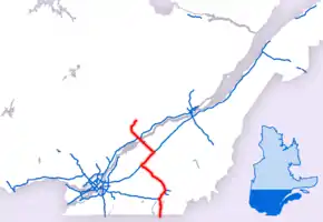
Quebec Autoroute 55
Autoroute 55 (also called Autoroute de l'Énergie north of the Autoroute 20 and Autoroute Joseph-Armand Bombardier south of it) is an important north–south Autoroute and the only one running in that direction in central Quebec. It is the longest north-south Autoroute, beginning as the continuation of I-91 at the Canada–United States border near Stanstead and continuing to Shawinigan, where it downgrades to Route 155. The total length of A-55 is currently 247 km (153.5 mi) long, including concurrencies with Autoroute 10, Autoroute 20 and Autoroute 40.
| ||||
|---|---|---|---|---|
| Autoroute Joseph-Armand Bombardier Autoroute de l'Énergie | ||||
 | ||||
| Route information | ||||
| Maintained by Transports Québec | ||||
| Length | 247.0 km[1][2] (153.5 mi) | |||
| Existed | 1964[2]–present | |||
| Major junctions | ||||
| South end | ||||
| North end | ||||
| Location | ||||
| Major cities | Sherbrooke, Drummondville, Trois-Rivières, Shawinigan | |||
| Highway system | ||||
| ||||

Route description
Autoroute 55 connects the mid-sized communities of Sherbrooke, Drummondville, Trois-Rivières, and Shawinigan and the smaller communities in between. The most notable feature on A-55 is the Laviolette Bridge between Trois-Rivières and Bécancour, which is one of the longest bridges in Quebec and in Canada.
A-55 had a short "gap" between Bécancour and Drummondville until October 2006. The gap resulted from Transports Quebec's original intention of bringing A-55 southeast towards Victoriaville along what is now Autoroute 955 before shifting southwest to rejoin existing A-55 near Richmond. However, plans changed in the 1970s, and the present routing was chosen. The southern section was originally supposed to be Autoroute 51 and was intended to continue to the planned extension of Autoroute 30 in Pierreville. A-55 was signed along Route 155 (which is not an Autoroute-standard highway) until the new route was completed.
All of the southern portion of A-55 became a full four-lane freeway by the end of October 2006. The gap being filled in the northern portion will initially be a two-lane freeway for about 20 km (12.4 mi), but it is intended to ultimately be four lanes.
The designation Autoroute Joseph-Armand Bombardier is in honour of Quebec businessman Joseph-Armand Bombardier, who lived in Valcourt, near where A-55 passes and who invented the snowmobile there. His company, Bombardier Inc., started by building snowmobiles and eventually grew into a major international manufacturer of transit vehicles and aircraft.
The designation Autoroute de l'Énergie means "Energy Highway" since it provides access to the Gentilly Nuclear Generating Station in Bécancour and the hydroelectric facilities in Shawinigan and the Haut-Saint-Maurice area, but the section north of A-30 is likely to remain at its comparatively short length to Shawinigan for the foreseeable future.
Exit list
| Region | RCM or ET | Location | km | mi | Old exit | New exit | Destinations | Notes |
|---|---|---|---|---|---|---|---|---|
| Estrie | Memphrémagog | Stanstead | Continues in Vermont | |||||
| Canada–United States border Derby Line–Rock Island Border Crossing South end of Autoroute Joseph-Armand Bombardier | ||||||||
| At-grade intersection; traffic signals | ||||||||
| 2 | ||||||||
| Stanstead-Est | 6 | Montée Baie Saint-Thomas | ||||||
| Chemin Curtis | At-grade intersection | |||||||
| Sainte-Catherine-de-Hatley | 21 | |||||||
| 29 | ||||||||
| Magog | 32 | Rue-Saint-Patrice, Boulevard Industriel | ||||||
| 33 | ||||||||
| 71[lower-roman 1] | 34 121[lower-roman 1] | A-55 branches east; south (west) end of A-10 concurrency; northbound signed as exits 34-E (east) and 34-O (west); southbound signed as 121 | ||||||
| Memphrémagog / Magog – Sherbrooke boundary | 72[lower-roman 1] 36 | 123[lower-roman 1] | ||||||
| City of Sherbrooke | 41 | 128[lower-roman 1] | ||||||
| 46 | 133[lower-roman 1] | Chemin Saint-Roch Nord | ||||||
| 50 | 137[lower-roman 1] | |||||||
| 54 | 140[lower-roman 1] | |||||||
| 55 | 141[lower-roman 1] | Boulevard de Monseigneur-Fortier | ||||||
| 143[lower-roman 1] | A-55 turns north; north (east) end of A-10 concurrency | |||||||
| 58 | ||||||||
| 60 | Rue Laval | |||||||
| Le Val-Saint-François | Windsor | 71 | Signed as exits 71N (north) and 71S (south) northbound | |||||
| Melbourne | 85 | |||||||
| 88 | ||||||||
| Ulverton | 98 | Chemin Mooney | ||||||
| Centre-du-Québec | Drummond | L'Avenir | 103 | Lefebvre, L'Avenir, Ulverton, Durham-Sud | ||||
| Drummondville | 111 | Route Caya | ||||||
| 116 | ||||||||
| 122 | Boulevard Jean-de-Brébeuf - Drummondville | |||||||
| 125 | ||||||||
| 128 173[lower-roman 2] | A-55 branches east; south (west) end of A-20 concurrency | |||||||
| North end of Autoroute Joseph-Armand Bombardier | ||||||||
| 175[lower-roman 2] | South (west) end of Route 143 concurrency | |||||||
| 177[lower-roman 2] | North (east) end of Route 143 concurrency | |||||||
| 179[lower-roman 2] | Chemin du Golf | |||||||
| Saint-Charles-de-Drummond | 181[lower-roman 2] | Saint-Charles-de-Drummond, Drummondville, Saint-Joachim-de-Courval | ||||||
| Saint-Cyrille-de-Wendover | 185[lower-roman 2] | |||||||
| Notre-Dame-du-Bon-Conseil | 191[lower-roman 2] | Sainte-Brigitte-des-Saults | ||||||
| 196[lower-roman 2] | ||||||||
| Drummond – Nicolet-Yamaska boundary | Notre-Dame-du-Bon-Conseil – Saint-Léonard-d'Aston boundary | 200[lower-roman 2] | Saint-Léonard-d'Aston | |||||
| Nicolet-Yamaska | Saint-Léonard-d'Aston | 202[lower-roman 2] | Rang du Moulin-Rouge | |||||
| Sainte-Eulalie | 204[lower-roman 2] | Rang des Cédres, Rang des Plaines | ||||||
| 210[lower-roman 2] 145 | A-55 branches north; north (east) end of A-20 concurrency; A-955 exit 15 | |||||||
| South end of Autoroute de l'Énergie | ||||||||
| Saint-Wenceslas | 153 | 9e Rang - Saint-Léonard-d'Aston, Saint-Wenceslas | ||||||
| Saint-Célestin (Municipality) | At-grade intersection; traffic signals | |||||||
| Bécancour | Bécancour | Rang Prince | At-grade intersection | |||||
| Chemin Forest - Précieux-Sang | At-grade intersection | |||||||
| Chemin Thibodeau | At-grade intersection | |||||||
| 173 | Saint-Grégoire, Nicolet, Wôlinak | |||||||
| 176 | Exit 209 on A-30 | |||||||
| Saint Lawrence River | Laviolette Bridge | |||||||
| Mauricie | City of Trois-Rivières | 181 | ||||||
| 182 | South end of A-40 concurrency; exit 197 on A-40 | |||||||
| 183 | Boulevard Jean-XXIII | |||||||
| 186 | North end of A-40 concurrency; exit 196 on A-40 | |||||||
| 191 | Boulevard Industriel, Boulevard Saint-Michel | |||||||
| 196 | Boulevard des Forges - Saint-Thomas-de-Caxton | |||||||
| Maskinongé | Saint-Étienne-des-Grès | 202 | Saint-Étienne-des-Grès, Saint-Barnabé | |||||
| 206 | Saint-Boniface | |||||||
| Saint-Boniface | 211 | |||||||
| City of Shawinigan | 181 | |||||||
| 216 | Rue Burrill | |||||||
| 217 | ||||||||
| 220 | Boulevard Hubert-Biermans, Boulevard Vallée-du-Parc | |||||||
| 223 | 5e avenue, 25e rue | |||||||
| 226 | 8e rue, 4e rue - Grand-Mère, Saint-Jean des Piles | |||||||
| Roundabout; A-55 northern terminus, continues north as Route 155 | ||||||||
| North end of Autoroute de l'Énergie | ||||||||
1.000 mi = 1.609 km; 1.000 km = 0.621 mi
| ||||||||
Gallery
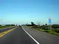 Autoroute 55 southbound
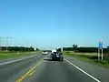 Southbound view, showing super-2 undivided highway
 Multiplex of Autoroutes 20 and 55
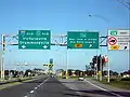 Southbound from Trois-Rivières at exit 181, approaching the Laviolette Bridge
References
- Ministère des transports, "Distances routières", page (?), Les Publications du Québec, 2005
- "Répertoire des autoroutes du Québec" (in French). Transports Québec. Archived from the original on 2010-01-11. Retrieved 2008-02-23.
External links
| Wikimedia Commons has media related to Quebec Autoroute 55. |