Mahia Peninsula
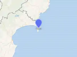
Mahia Peninsula (official name: Māhia Peninsula; Maori: Māhia or Te Māhia)[2][3] is located on the east coast of New Zealand's North Island, in the Hawke's Bay region, between the cities of Napier and Gisborne.
Mahia Peninsula | |
|---|---|
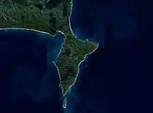 NASA satellite image of the Mahia Peninsula | |
| |
| Coordinates: 39°09′S 177°54′E | |
| Country | New Zealand |
| Region | Hawke's Bay |
| Territorial authority | Wairoa |
| Population (2018)[1] | |
| • Total | 1,119 |
| Time zone | UTC+12 (NZST) |
| • Summer (DST) | UTC+13 (NZDT) |
| Postcode | 4198 |
Rocket Lab has set up its Launch Complex 1 close to Ahuriri Point at the southern tip of the peninsula to launch its Electron rocket. Test launches of the Electron started in 2017. During regular operations, it will be used as a commercial launcher of small satellites in the range of 135–235 kg, and miniature satellites called CubeSats.[4] New Zealand's first orbital space launch took place from Launch Complex 1 on 21 January 2018.
Geography
The peninsula is 21.7 kilometres (13.5 mi) long and 11.3 km (7 mi) wide. Its highest point is Rahuimokairoa, 397 m (1,302 ft) above sea level. The peninsula was once an island, but now a tombolo joins it to the North Island.[5]
Demographics
| Year | Pop. | ±% p.a. |
|---|---|---|
| 2006 | 1,272 | — |
| 2013 | 1,104 | −2.00% |
| 2018 | 1,119 | +0.27% |
| Source: [1] | ||
The statistical area of Mahia, which at 472 square kilometres is larger than the peninsula and includes Nuhaka, had a population of 1,119 at the 2018 New Zealand census. This was a decrease of 153 people (-12.0%) since the 2006 census. There were 456 households. The median age was 49 years, compared with 37.4 years nationally. Ethnicities were 64.9% Māori, 48.8% European/Pākehā, 1.1% Pacific peoples, 0.8% Asian, and 1.3% other ethnicities (totals add to more than 100% since people could identify with multiple ethnicities). This compares with a 16.5% of New Zealanders identifying as Māori.
Although some people objected to giving their religion, 35.4% had no religion, 49.3% were Christian and 9.1% had other religions.
Of those at least 15 years old, 126 (13.9%) people had a bachelor or higher degree, and 207 (22.8%) people had no formal qualifications. The median income was $21,400, compared with $31,800 nationally. The employment status of those at least 15 was that 339 (37.3%) people were employed full-time, 150 (16.5%) were part-time, and 72 (7.9%) were unemployed.[1]
History and culture
Māori history
In Maori legend, Whatonga, who came to New Zealand in search of his grandfather Toi, settled at Mahia.
The peninsula is the tribal area of the Ngāti Rongomaiwahine iwi.[6] The word māhia means "indistinct sound" or "scrofulous swelling".[7] The name "Te Māhia" comes from "Te Māhia-mai-tawhiti" (the sound heard from a distance).
Portland Island, also called Waikawa, is a small island off the southern tip of Mahia Peninsula. It was named Waikawa by Kahungunu when he visited there to look for fresh drinking water and only found salt water – Waikawa means "sour water". Portland Island has an unmanned lighthouse.
European history
Shore whaling was briefly important on the Mahia Peninsula. Early whalers had a whaling station on the farm "Kini Kini", sheltered by "Long Point" on the west coast of the peninsula.[8][9] The peninsula community these days is still generally a mix of Maori and European.
Prime Minister Jacinda Ardern was proposed to by her partner, Clarke Gayford, on Mokotahi Hill.[10]
Marae
There are four marae in the Mahia area affiliated with the hapū of the Ngāti Kahungunu iwi:[11][12]
- The Kaiuku or Oku-ra-renga Marae and its Kiwi meeting house are affiliated with the hapū of Ngāti Tama, Ngāi Tū and Rongomaiwahine.
- Te Rākatō Marae is affiliated with the hapū of Ngāi Rākatō.
- Tuahuru Marae and its Hine te Rongo meeting house are affiliated with the hapū of Ngāti Tama, Ngāi Tū and Rongomaiwahine.
- Ruawharo Marae is also affiliated with Ngāti Tama and Rongomaiwahine.
In October 2020, the Government committed $1,949,075 from the Provincial Growth Fund to upgrade 24 Ngāti Kahungunu marae, including both Kaiuku and Ruawharo Marae, creating 164 jobs. It also committed $102,644 to upgrading Tuahuru Marae, creating 4 jobs.[13]
Economy
Sheep and cattle farms are an important part for the local community, but tourism is now the peninsula's main industry. Mahia's population swells greatly during the warmer months and in particular during school holidays.
Mahia is well known for its surf, scuba diving, hiking, and fishing.[14] Morere Hot Springs is 15 minutes away, towards Gisborne. The area is a popular school holiday destination and contains a holiday park dating back to the 1960s. The remaining settlement consists mostly of holiday houses and baches.
From 2007 to 2010 Mahia became known for the presence of Moko, a dolphin.
Education
Te Mahia School is a year 1–8 co-educational state primary school.[15] It is a decile 1 school with a roll of 56 as of March 2020.[16][17] The school opened in 1917.[18]
References
| Wikimedia Commons has media related to Mahia Peninsula. |
- "Statistical area 1 dataset for 2018 Census". Statistics New Zealand. March 2020. Mahia (207900). 2018 Census place summary: Mahia
- "NZGB Gazetteer". gazetteer.linz.govt.nz. Retrieved 15 December 2020.
- Whaanga, Mere (10 February 2015). "Ngāti Rongomaiwahine – Māhia Peninsula". Te Ara – the Encyclopedia of New Zealand. Manatū Taonga Ministry for Culture and Heritage. Retrieved 8 February 2018.
- Rocket Lab Plans Electron Test Launches This Year. Jeff Foust, Space News. 19 April 2016.
- "Destination: Mahia Peninsula". The New Zealand Bay Fisher. Ink IQ. Retrieved 8 February 2018.
- "Story: Ngāti Rongomaiwahine".
- Williams, Herbert W. (1971). "Māhia". A Dictionary of the Maori Language (7th ed.). p. 163.
- "Shore-based whaling". Te Ara. Retrieved 22 May 2017.
- Shortt, Bill (7 February 2016). "Mahia takes the cake". The Gisborne Herald. Retrieved 8 February 2018.
- Bateman, Sophie (6 May 2019). "PM Jacinda Ardern spills details on 'very romantic' proposal". Newshub. Retrieved 15 December 2020.
- "Te Kāhui Māngai directory". tkm.govt.nz. Te Puni Kōkiri.
- "Māori Maps". maorimaps.com. Te Potiki National Trust.
- "Marae Announcements" (Excel). growregions.govt.nz. Provincial Growth Fund. 9 October 2020.
- "Mahia Travel Guide". Jasons Travel Media.
- "Ministry of Education School Profile". educationcounts.govt.nz. Ministry of Education.
- "New Zealand Schools Directory". New Zealand Ministry of Education. Retrieved 26 April 2020.
- "Education Review Office Report". ero.govt.nz. Education Review Office.
- Te Mahia School 75th jubilee and Tawapata School reunion magazine. Te Mahia School. 1992.