Maine State Route 105
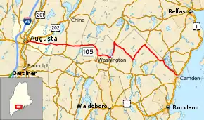
State Route 105 (SR 105) is a highway in the south-central part of the U.S. state of Maine. SR 105 begins in Augusta at Cony Circle where it intersects U.S. Route 201 (US 201), US 202, and State Routes 9, 17, and 100. It continues east approximately for 48 miles (77 km) until it terminates at US 1 in Camden. It is regarded as one of the most scenic drives in Maine.
| ||||
|---|---|---|---|---|
 | ||||
| Route information | ||||
| Maintained by MaineDOT | ||||
| Length | 47.7 mi[1] (76.8 km) | |||
| Major junctions | ||||
| West end | ||||
| East end | ||||
| Location | ||||
| Counties | Kennebec, Lincoln, Waldo, Knox | |||
| Highway system | ||||
| ||||

Major intersections
.jpg.webp)
SR 105 at SR 32 in Windsor
| County | Location[2] | mi[1] | km | Destinations | Notes | |||
|---|---|---|---|---|---|---|---|---|
| Kennebec | Augusta | 0.0 | 0.0 | West end of SR 105; Cony Circle (roundabout) | ||||
| Windsor | 9.7 | 15.6 | ||||||
| Lincoln |
No major junctions | |||||||
| Knox | Washington | 18.6 | 29.9 | |||||
| 22.1 | 35.6 | West end of overlap with SR 220 | ||||||
| Waldo | Liberty | 25.6 | 41.2 | East end of overlap with SR 220 | ||||
| Knox | Appleton | 31.8 | 51.2 | West end of overlap with SR 131 | ||||
| 36.4 | 58.6 | East end of overlap with SR 131 | ||||||
| Hope | 41.1 | 66.1 | West end of overlap with SR 235 | |||||
| 42.4 | 68.2 | East end of overlap with SR 235 | ||||||
| Camden | 47.7 | 76.8 | East end of SR 105 | |||||
1.000 mi = 1.609 km; 1.000 km = 0.621 mi
| ||||||||
References
- Google (August 27, 2016). "SR 105" (Map). Google Maps. Google. Retrieved August 27, 2016.
- DeLorme (2011). "Maps 12-14, 76, 79" (Map). The Maine Atlas and Gazetteer (32nd ed.). Yarmouth, ME: DeLorme.
External links
 Media related to Maine State Route 105 at Wikimedia Commons
- Floodgap Roadgap's RoadsAroundME: Maine State Route 105
This article is issued from Wikipedia. The text is licensed under Creative Commons - Attribution - Sharealike. Additional terms may apply for the media files.