Manns Harbor, North Carolina
Manns Harbor is a census-designated place (CDP) in Dare County, North Carolina, United States. As of the 2010 census it had a population of 821.[2]
Manns Harbor, North Carolina | |
|---|---|
 Methodist church | |
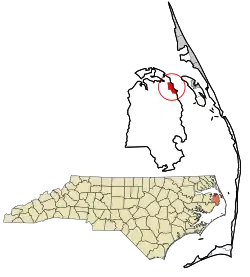 Location in Dare County and the state of North Carolina. | |
| Coordinates: 35°53′09″N 75°45′46″W | |
| Country | United States |
| State | North Carolina |
| County | Dare County |
| Area | |
| • Total | 4.10 sq mi (10.61 km2) |
| • Land | 4.08 sq mi (10.56 km2) |
| • Water | 0.02 sq mi (0.05 km2) |
| Elevation | 5 ft (2 m) |
| Population (2010) | |
| • Total | 821 |
| • Density | 202/sq mi (77.8/km2) |
| Time zone | UTC-5 (Eastern (EST)) |
| • Summer (DST) | UTC-4 (EDT) |
| ZIP code | 27953 |
| Area code(s) | 252 |
| GNIS feature ID | 989288[1] |
| FIPS code | 37-40980 |
Overview
Before the first settlers arrived in the vicinity of Manns Harbor, the Native American village Dasamongueponke existed on or close to the site.
Located east of the intersection of U.S. Routes 64 and 264, it is nestled along the western bank of Croatan Sound. Before 1957, Manns Harbor used to harbor a ferry that traversed the sound and provided access to Roanoke Island. Today, the William B. Umstead Bridge (completed in 1957) and the four-lane Virginia Dare Memorial Bridge (completed in 2002) link Manns Harbor on the mainland to Manteo on Roanoke Island. The community provides a gateway to North Carolina's Outer Banks.[3]
The residents of Manns Harbor are governed by the Dare County Board of Commissioners. Manns Harbor is part of District 1, along with Manteo, Roanoke Island, and Wanchese.
Airports
The Hyde County airport and Dare County Regional Airport are the closest airports.
References
- U.S. Geological Survey Geographic Names Information System: Manns Harbor, North Carolina
- "Geographic Identifiers: 2010 Demographic Profile Data (G001): Manns Harbor CDP, North Carolina". U.S. Census Bureau, American Factfinder. Archived from the original on February 13, 2020. Retrieved November 24, 2015.
- "Croatan Sound Bridge, Manteo, NC - Road Traffic Technology". Retrieved 2011-02-11.
Municipalities and communities of Dare County, North Carolina, United States | ||
|---|---|---|
| Towns | 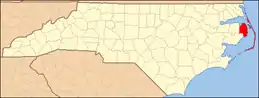 Dare County map | |
| CDPs | ||
| Unincorporated communities | ||
| Ghost town | ||
| ||