Marienville, Pennsylvania
Marienville is an unincorporated community and census-designated place (CDP) in Jenks Township, Forest County, Pennsylvania, United States. Its altitude is 1,735 feet (529 m), and it is located at 41°28′12″N 79°7′29″W (41.4702014, -79.1247623). Other names for the community have included "Marion", "Marion Centre", and "Marionville".[1] Marienville is a major point on a well-known ATV trail.[2] According to the 2010 census the population of Marienville was 3,137.[3]
Marienville, Pennsylvania | |
|---|---|
 Marienville, Pennsylvania | |
 Marienville  Marienville | |
| Coordinates: 41°28′8″N 79°7′23″W | |
| Country | United States |
| State | Pennsylvania |
| County | Forest |
| Township | Jenks |
| Area | |
| • Total | 6.1 sq mi (15.7 km2) |
| • Land | 6.1 sq mi (15.7 km2) |
| • Water | 0.0 sq mi (0.0 km2) |
| Elevation | 1,735 ft (529 m) |
| Population (2010) | |
| • Total | 3,137 |
| • Density | 519/sq mi (200.3/km2) |
| Time zone | UTC-5 (Eastern (EST)) |
| • Summer (DST) | UTC-4 (EDT) |
| ZIP code | 16239 |
| FIPS code | 42-47416 |
| GNIS feature ID | 1213633 |
Marienville is the location of the SCI Forest state penitentiary.
Geography
The community is in southeastern Forest County near the center of Jenks Township. Pennsylvania Route 66 is the main street, leading northeast 24 miles (39 km) to U.S. Route 6 at Kane and southwest 27 miles (43 km) to Interstate 80 near Clarion. Pennsylvania Route 899 leads south from Marienville 10 miles (16 km) to Clarington.
According to the U.S. Census Bureau, the Marienville CDP has a total area of 6.1 square miles (15.7 km2), all land.[3]
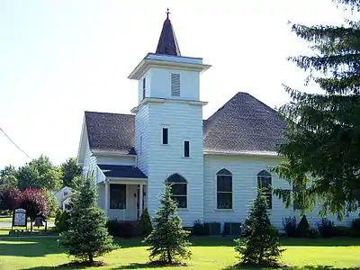 Marienville Presbyterian Church
References
| Wikimedia Commons has media related to Marienville, Pennsylvania. |
- U.S. Geological Survey Geographic Names Information System: Marienville, Pennsylvania
- http://www.fs.fed.us/r9/forests/allegheny/recreation/atv_trails/marienville/
- "Geographic Identifiers: 2010 Census Summary File 1 (G001), Marienville CDP, Pennsylvania". American FactFinder. U.S. Census Bureau. Archived from the original on February 13, 2020. Retrieved July 28, 2016.
Municipalities and communities of Forest County, Pennsylvania, United States | ||
|---|---|---|
| Borough |  | |
| Townships | ||
| CDP | ||
| Unincorporated communities | ||
| Ghost town | ||
| Footnotes | ‡This populated place also has portions in an adjacent county or counties | |
| ||