Forest County, Pennsylvania
Forest County is a county located in Western Pennsylvania. As of the 2010 census, the population was 7,716,[1] making it the third-least populous county in Pennsylvania. Its county seat is Tionesta.[2] The county was created in 1848 and later organized in 1857.[3]
Forest County | |
|---|---|
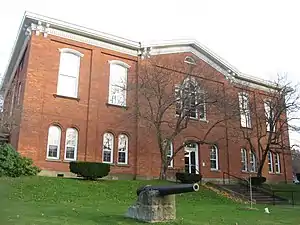 Forest County Courthouse, Tionesta | |
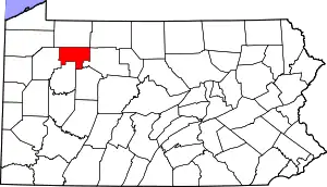 Location within the U.S. state of Pennsylvania | |
 Pennsylvania's location within the U.S. | |
| Coordinates: 41°31′N 79°14′W | |
| Country | |
| State | |
| Founded | September 1, 1857 |
| Seat | Tionesta |
| Largest community | Marienville |
| Area | |
| • Total | 430 sq mi (1,100 km2) |
| • Land | 427 sq mi (1,110 km2) |
| • Water | 3.3 sq mi (9 km2) 0.8%% |
| Population | |
| • Estimate (2018) | 7,279 |
| • Density | 17/sq mi (7/km2) |
| Time zone | UTC−5 (Eastern) |
| • Summer (DST) | UTC−4 (EDT) |
| Congressional district | 15th |
| Website | www |
History
Forest County was created on April 11, 1848, from part of Jefferson County. The county was enlarged on October 31, 1866, when part of Venango County was incorporated into the county. Forest County was named for the forests contained within its limits.[4]
Geography
According to the U.S. Census Bureau, the county has a total area of 430 square miles (1,100 km2), of which 427 square miles (1,110 km2) is land and 3.3 square miles (8.5 km2) (0.8%) is water.[5] It has a warm-summer humid continental climate (Dfb) and average monthly temperatures in Tionesta range from 25.3 °F in January to 69.8 °F in July.
Adjacent counties
- Warren County (north)
- McKean County (northeast)
- Elk County (east)
- Jefferson County (south)
- Clarion County (south)
- Venango County (west)
National protected area
Part of Allegheny National Forest covers Forest County.
State protected area
Part of Cook Forest State Park is in Forest County.
Demographics
| Historical population | |||
|---|---|---|---|
| Census | Pop. | %± | |
| 1860 | 898 | — | |
| 1870 | 4,010 | 346.5% | |
| 1880 | 4,385 | 9.4% | |
| 1890 | 8,482 | 93.4% | |
| 1900 | 11,039 | 30.1% | |
| 1910 | 9,435 | −14.5% | |
| 1920 | 7,477 | −20.8% | |
| 1930 | 5,180 | −30.7% | |
| 1940 | 5,791 | 11.8% | |
| 1950 | 4,944 | −14.6% | |
| 1960 | 4,485 | −9.3% | |
| 1970 | 4,926 | 9.8% | |
| 1980 | 5,072 | 3.0% | |
| 1990 | 4,802 | −5.3% | |
| 2000 | 4,946 | 3.0% | |
| 2010 | 7,716 | 56.0% | |
| 2018 (est.) | 7,279 | [6] | −5.7% |
| U.S. Decennial Census[7] 1790-1960[8] 1900-1990[9] 1990-2000[10] 2010-2017[1] | |||
As of the census[11] of 2000, there were 4,946 people, 2,000 households, and 1,328 families residing in the county. The population density was 12 people per square mile (4/km2). There were 8,701 housing units at an average density of 20 per square mile (8/km2). The racial makeup of the county was 95.94% White, 2.22% Black or African American, 0.40% Native American, 0.14% Asian, 0.69% from other races, and 0.61% from two or more races. 1.21% of the population were Hispanic or Latino of any race. 40.5% English or Welsh, 14.4% were of German, 10.1% Irish, 12.5% American, 10.1% Irish, 6.8% Scotch-Irish, 2.4% Dutch, and 2.2% French ancestry.
There were 2,000 households, out of which 23.20% had children under the age of 18 living with them, 55.70% were married couples living together, 6.70% had a female householder with no husband present, and 33.60% were non-families. 29.10% of all households were made up of individuals, and 15.10% had someone living alone who was 65 years of age or older. The average household size was 2.29 and the average family size was 2.81.
In the county, the population was spread out, with 22.70% under the age of 18, 5.90% from 18 to 24, 22.60% from 25 to 44, 28.90% from 45 to 64, and 19.90% who were 65 years of age or older. The median age was 44 years. For every 100 females there were 111.20 males. For every 100 females age 18 and over, there were 102.30 males.
- Birth rate
Forest County's live birth rate was 52 births in 1990. The county's live birth rate in 2000 declined to 40 births, while in 2011 it had declined again to 39 babies.[12] Over the past 50 years (1960 to 2010), rural Pennsylvania saw a steady decline in both the number and proportion of residents under 18 years old. In 1960, 1.06 million rural residents, or 35 percent of the rural population, were children.
- County poverty demographics
According to research by The Center for Rural Pennsylvania, which is a legislative Agency of the Pennsylvania General Assembly, the poverty rate for Forest County was 21.9% in 2014.[13] The statewide poverty rate was 13.6% in 2014. The 2012 childhood poverty rate at Forest Area School District was 57.8% living at 185% or below than the Federal Poverty Level.[14]
- Teen Pregnancy rate
Forest County reported no babies born to teens (ages 15–19) in 2011. In 2015, the number of teen births in Forest County was 16.[15]
Law and government
| Year | Republican | Democratic | Third parties |
|---|---|---|---|
| 2020 | 71.1% 1,882 | 27.5% 728 | 1.4% 36 |
| 2016 | 69.6% 1,683 | 25.9% 626 | 4.6% 110 |
| 2012 | 59.5% 1,383 | 38.6% 896 | 1.9% 45 |
| 2008 | 55.4% 1,366 | 42.1% 1,038 | 2.6% 64 |
| 2004 | 61.1% 1,571 | 38.4% 989 | 0.5% 13 |
| 2000 | 60.1% 1,371 | 36.9% 843 | 3.0% 69 |
| 1996 | 41.0% 902 | 43.8% 964 | 15.2% 335 |
| 1992 | 37.4% 801 | 41.5% 890 | 21.1% 453 |
| 1988 | 56.1% 1,159 | 43.3% 895 | 0.5% 11 |
| 1984 | 63.4% 1,468 | 36.2% 839 | 0.4% 10 |
| 1980 | 56.1% 1,206 | 38.1% 819 | 5.8% 124 |
| 1976 | 51.9% 1,135 | 46.5% 1,017 | 1.6% 35 |
| 1972 | 71.8% 1,374 | 26.6% 509 | 1.7% 32 |
| 1968 | 59.4% 1,172 | 33.9% 669 | 6.7% 132 |
| 1964 | 41.8% 900 | 58.0% 1,249 | 0.2% 5 |
| 1960 | 64.2% 1,497 | 35.5% 828 | 0.3% 7 |
| 1956 | 71.1% 1,535 | 28.8% 622 | 0.1% 1 |
| 1952 | 69.9% 1,511 | 29.0% 627 | 1.1% 23 |
| 1948 | 62.3% 1,209 | 35.4% 687 | 2.3% 45 |
| 1944 | 66.0% 1,344 | 33.0% 673 | 1.0% 21 |
| 1940 | 66.2% 1,811 | 33.6% 919 | 0.2% 6 |
| 1936 | 59.5% 1,757 | 39.2% 1,157 | 1.3% 39 |
| 1932 | 63.3% 1,090 | 33.1% 569 | 3.6% 62 |
| 1928 | 84.6% 1,707 | 14.3% 289 | 1.1% 22 |
| 1924 | 71.2% 1,130 | 17.6% 280 | 11.2% 177 |
| 1920 | 56.4% 993 | 22.1% 389 | 21.6% 380 |
| 1916 | 47.0% 617 | 35.3% 463 | 17.7% 232 |
| 1912 | 15.4% 240 | 23.9% 373 | 60.7% 947 |
| 1908 | 60.9% 1,119 | 27.9% 512 | 11.2% 206 |
| 1904 | 68.1% 1,328 | 21.1% 411 | 10.8% 210 |
| 1900 | 61.3% 1,309 | 33.4% 714 | 5.3% 114 |
| 1896 | 57.7% 1,224 | 38.0% 805 | 4.3% 91 |
| 1892 | 54.3% 938 | 38.2% 660 | 7.5% 129 |
| 1888 | 57.2% 917 | 38.2% 612 | 4.6% 73 |
State Senate[17]
State House of Representatives[17]
- Donna Oberlander, Republican, Pennsylvania's 63rd Representative District
- Kathy L. Rapp, Republican, Pennsylvania's 65th Representative District
United States House of Representatives
United States Senate
Education
The Forest Area School District serves the entire Forest County. The District ranked 421st out of the 493 ranked Pennsylvania school districts in 2015.[18]
Private schools
- Cornell Abraxas I Arlene Lissner (9th-12th) Marienville
Libraries
- Marienville Area Library - Marienville
- Sarah Stewart Bovard Memorial Library - Tionesta
Communities
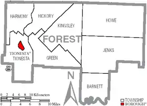
Under Pennsylvania law, there are four types of incorporated municipalities: cities, boroughs, townships, and, in at most two cases, towns. The following boroughs and townships are located in Forest County:
Borough
- Tionesta (county seat)
Census-designated place
Unincorporated communities
Population ranking
The population ranking of the following table is based on the 2010 census of Forest County.[19] The jump in census figures between the 2000 and 2010 census, is due in a large part to the opening of the State Correctional Institution - Forest (SCI - Forest) in October 2004. SCI Forest houses approximately 2,200 inmates at their facility in Marienville, PA.
† county seat
| Rank | City/Town/etc. | Population (2010 Census) | Municipal type | Incorporated |
|---|---|---|---|---|
| 1 | Marienville | 3,137 | CDP | |
| 2 | † Tionesta | 483 | Borough | 1805 |
References
- "State & County QuickFacts". United States Census Bureau. Archived from the original on June 6, 2011. Retrieved November 17, 2013.
- "Find a County". National Association of Counties. Archived from the original on May 31, 2011. Retrieved June 7, 2011.
- "Pennsylvania: Individual County Chronologies". Pennsylvania Atlas of Historical County Boundaries. The Newberry Library. 2008. Archived from the original on March 25, 2015. Retrieved March 12, 2015.
- Gannett, Henry (1905). The Origin of Certain Place Names in the United States. Govt. Print. Off. pp. 128. Retrieved 2016-10-15.
- "2010 Census Gazetteer Files". United States Census Bureau. August 22, 2012. Archived from the original on September 4, 2015. Retrieved March 7, 2015.
- "Population and Housing Unit Estimates". Archived from the original on May 2, 2019. Retrieved October 10, 2018.
- "U.S. Decennial Census". United States Census Bureau. Retrieved March 7, 2015.
- "Historical Census Browser". University of Virginia Library. Archived from the original on August 11, 2012. Retrieved March 7, 2015.
- Forstall, Richard L., ed. (March 24, 1995). "Population of Counties by Decennial Census: 1900 to 1990". United States Census Bureau. Archived from the original on March 20, 2015. Retrieved March 7, 2015.
- "Census 2000 PHC-T-4. Ranking Tables for Counties: 1990 and 2000" (PDF). United States Census Bureau. April 2, 2001. Archived (PDF) from the original on December 18, 2014. Retrieved March 7, 2015.
- "U.S. Census website". United States Census Bureau. Retrieved 2008-01-31.
- Pennsylvania Department of Health, Birth Age County Reports 1990 and 2011, 2011
- US Census Bureau (2015). "Poverty Rates by County Small Area Income and Poverty Estimates". Archived from the original on 2015-12-22. Retrieved 2015-12-31.
- Pennsylvania Budget and Policy Center (2012). "Student Poverty Concentration 2012". Archived from the original on 2015-12-22. Retrieved 2015-12-31.
- Robert Wood Johnson Foundation (2016). "Pennsylvania Teen Births 2015". Archived from the original on 2017-08-28. Retrieved 2016-05-12.
- Leip, David. "Dave Leip's Atlas of U.S. Presidential Elections". uselectionatlas.org. Archived from the original on 23 March 2018. Retrieved 25 November 2018.
- Center, Legislativate Data Processing. "Find Your Legislator". The official website for the Pennsylvania General Assembly. Archived from the original on 2017-05-06. Retrieved 2017-05-11.
- Pittsburgh Business Times (April 10, 2015). "Guide to Pennsylvania Schools Statewide School District Ranking 2015". Archived from the original on August 20, 2015. Retrieved December 31, 2015.
- "2010 U.S. Census website". United States Census Bureau. Retrieved 2013-02-10.
Municipalities and communities of Forest County, Pennsylvania, United States | ||
|---|---|---|
| Borough | | |
| Townships | ||
| CDP | ||
| Unincorporated communities | ||
| Ghost town | ||
| Footnotes | ‡This populated place also has portions in an adjacent county or counties | |
| ||

| Authority control |
|---|