Mariscal Nieto Province
The Mariscal Nieto Province (Spanish mariscal marshal) is the largest of three provinces that make up the Moquegua Region of Peru.[1][2] The capital of the province is the city of Moquegua.
Mariscal Nieto | |
|---|---|
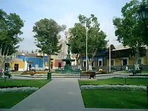 Plaza de Armas in the capital Moquegua | |
 Flag  Coat of arms | |
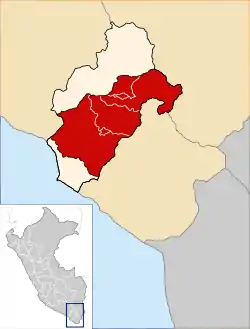 Location of Mariscal Nieto in the Moquegua Region | |
| Country | Peru |
| Region | Moquegua |
| Founded | April 3, 1936 |
| Capital | Moquegua |
| Government | |
| • Mayor | Abraham Alejandro Cárdenas Romero (2019-2022) |
| Area | |
| • Total | 8,671.58 km2 (3,348.12 sq mi) |
| Elevation | 1,410 m (4,630 ft) |
| Population | |
| • Total | 85,349 |
| • Density | 9.8/km2 (25/sq mi) |
| UBIGEO | 1801 |
| Website | http://www.munimoquegua.gob.pe |
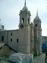
Cathedral of Moquegua
Boundaries
- North: General Sánchez Cerro Province
- East: Tacna Region
- South: Ilo Province
- West: Arequipa Region
Geography
Some of the highest mountains of the province are listed below:[3]
- Achuqallani
- Apachita Limani
- Arichuwa (Moquegua)
- Arichuwa (Moquegua-Tacna)
- Chaka Apachita
- Chinchillani
- Chiñi Lakha
- Chuqi Ananta
- Churi Laq'a
- Ch'alluma
- Ch'iyar Jaqhi
- Ch'ankhani
- Iru Uma
- Iruma
- Jach'a K'uchu
- Jach'a Q'awa
- Jach'a Sirka
- Janq'u Llaqa
- Jat'ita Patxa
- Kuntur Ikiña
- Kuntur Nasa
- Kunturini
- Khunu Qullu
- K'ank'awini
- Llallawani
- Mawruma
- Millu
- Misa Qalani
- Paxsi Awki
- Pinkilluni
- Puma Sulu
- Pumani
- Phaq'u Q'awa
- Phaq'u Tanka
- Qala Patxa
- Qina Mich'ini
- Qina Qinani
- Q'iwiri
- Qiwña Milluku
- Qupa Phuju
- Qurini
- Qutani
- Qhini Jamach'ini
- Sirka Sirka
- Suri Wayku
- Taypi Patxa
- Titini
- Tixani
- Tutupaka
- Uma Jalsu
- Wañuma
- Warintapani
- Wawa Chaki
- Wayllani
- Waytiri
- Wilaquta
- Wila Wilani
- Willkani
- Wisk'acha
- Yaritani
- Yunkani
Political division
The province is divided into six districts, which are:
| District | Capital | Mayor |
|---|---|---|
| Moquegua | Moquegua | Abraham Alejandro Cárdenas Romero |
| Carumas | Carumas | Luis Victor Salas Casilla |
| Cuchumbaya | Cuchumbaya | Guido Maquera Cuayla |
| Samegua | Samegua | Renso Milthon Florencio Quiroz Vargas |
| San Cristóbal | Calacoa | Rogelio Leonardo Vizcarra Taco |
| Torata | Torata | Higinio Zoilo Cabana Diaz |
Ethnic groups
The province is inhabited by indigenous citizens of Aymara and Quechua descent. Spanish, however, is the language which the majority of the population (79.51%) learnt to speak in childhood, 15.65% of the residents started speaking using the Aymara language and 4.45% using Quechua (2007 Peru Census).[4]
See also
References
- (in Spanish) INEI
- (in Spanish) IPAM
- escale.minedu.gob.pe - UGEL map of the Mariscal Nieto Province (Tacna Region)
- inei.gob.pe Archived 2013-01-27 at the Wayback Machine INEI, Peru, Censos Nacionales 2007
External links
| |
|---|---|
This article is issued from Wikipedia. The text is licensed under Creative Commons - Attribution - Sharealike. Additional terms may apply for the media files.