Maritsa
Maritsa (Bulgarian: Марица [mɐˈrit͡sɐ]), also known as Meriç (Turkish: Meriç [meɾit͡ʃ]) or Evros (Greek: Έβρος [ˈevros]), is a river that runs through the Balkans in Southeast Europe. With a length of 480 km (300 mi),[3] it is the longest river of those that flow directly into the World Ocean and run solely in the interior of the Balkan peninsula, and one of the largest in Europe by discharge. It originates in Rila mountain and flows through Bulgaria in its upper and middle reaches, while its lower course forms much of the border between Greece and Turkey. Its drainage area is about 53,000 km2 (20,000 sq mi), of which 66.2% is in Bulgaria, 27.5% in Turkey and 6.3% in Greece.[1] It is the main river of the historical region of Thrace, most of which lies in its drainage basin.
| Maritsa Évros, Meriç | |
|---|---|
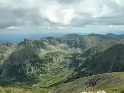 The source valley of the Maritsa river in the Rila Mountains | |
| Native name | Bulgarian: Марица Greek: Έβρος Turkish: Meriç |
| Location | |
| Countries | |
| Physical characteristics | |
| Source | |
| • location | Rila Mountains, Bulgaria |
| • elevation | 2,378 m (7,802 ft) |
| Mouth | |
• location | Aegean Sea, 14.5 km (9.0 mi) east of Alexandroupoli |
• coordinates | 40°43′50″N 26°2′6″E |
| Length | 480 km (300 mi) |
| Basin size | 53,000 km2 (20,000 sq mi)[1] |
| Discharge | |
| • average | for mouth 234 m3/s (8,300 cu ft/s)[2] |
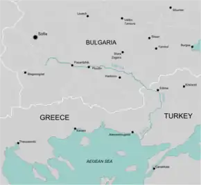
It has its origin in the Rila Mountains in Western Bulgaria, flowing southeast between the Balkan and Rhodope Mountains, past Plovdiv and Parvomay (where the Mechka and the Kayaliyka join it) to Edirne, Turkey. East of Svilengrad, Bulgaria, the river flows eastwards, forming the border between Bulgaria (on the north bank) and Greece (on the south bank), and then between Turkey and Greece. At Edirne, the river flows through Turkish territory on both banks, then turns towards the south and forms the border between Greece on the west bank and Turkey on the east bank to the Aegean Sea. Turkey was given a small sector on the west bank opposite the city of Edirne. Maritsa then flows past Kastanies, Pythio, Didymoteicho and Lavara in Greece. It enters the Aegean near Enez, where it forms a river delta. The Tundzha is its chief tributary; the Arda is another one. The lower course of the Maritsa/Evros forms part of the Bulgarian–Greek border and most of the Greek–Turkish border. The upper Maritsa valley is a principal east–west route in Bulgaria. The unnavigable river is used for power production and irrigation.
Etymology
The earliest known name of the river is Euros (Εύρος, Alcman, 7th–6th century BC).[4] Indo-European *ewru and Ancient Greek εύρύs meant "wide".[4] The Indo-European "wr" sound shifted in Thracian to "br", creating the Thracian name Ebros.[4] Thereafter, the river began to be known as Hébros (Ἕβρος) in Greek and Hebrus in Latin.[5] Rather than an origin as "wide river", an alternative hypothesis is that Hebros meant "goat" in Thracian.[6]
Since, when first attested, Europe referred only to Thrace proper,[7] the name of the continent is possibly derived from this river.
While the name Έβρος (Hebros) was used in Ancient Greek, the name Μαρίτσα (Maritsa) had become standard before the ancient form Έβρος (now: Évros) was artificially restituted in Modern Greek.[8] The name Maritsa may derive from a mountain near the mouth of the river known in antiquity as Μηρισός or Μήριζος, Latinized as Merit(h)us.[4]
History
In 1371, the river was the site of the Battle of Maritsa, also known as the battle of Chernomen, an Ottoman victory over the Serbs. Vukašin Mrnjavčević and Jovan Uglješa died in the battle.
Illegal transborder migration
The Maritsa/Evros river as a natural barrier on the border between Turkey and Greece has become a major route for migrants from a variety of countries attempting to enter the EU illegally.[9] At the height of the 2010s migrant crisis, in 2012, a border barrier was erected on the Greek side in order to prevent illegal crossings into Greece and thus into the EU.
Following the heavy losses Turkish armed forces incurred at the hands of the Russian-backed Syrian government in northern Syria at the end of February 2020, a drastic change in Turkey's policy towards irregular migrants on its territory led to escalation of the situation at the Evros border crossings as well as exacerbation of tension between Turkey on one hand and Greece and the EU as a whole on the other hand.[10][11]
In May 2020, news emerged that Turkish forces occupied a 16 acres (6.5 ha) of Greek territory, Melissokomeio, as shown on maps of 1923, following a change in the flow of the Maritsa/Evros river.[12]
Tributaries
Starting from the river's source, significant tributaries of Maritsa include:
- Left tributaries:
- Topolnitsa (flows into Maritsa near Pazardzhik)
- Luda Yana (near Ognyanovo)
- Stryama (near Sadovo)
- Sazliyka (near Simeonovgrad)
- Tundzha/Tunca (in Edirne)
- Ergene (near İpsala)
- Right tributaries:
- Chepinska reka (near Septemvri)
- Vacha (near Stamboliyski)
- Chepelarska reka (near Sadovo)
- Harmanliyska reka (near Harmanli)
- Arda/Ardas (near Edirne)
- Erythropotamos/Luda reka (near Didymoteicho)
Floods
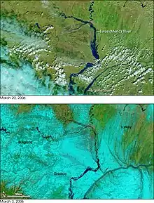
The lower course of the river Maritsa/Evros, where it forms the border of Greece and Turkey, is very vulnerable to flooding. For about 4 months every year, the low lands around the river are flooded. This causes significant economic damage (loss of agricultural production and damage to infrastructure), which is estimated at several hundreds million Euro.[13]
Recent large floods took place in 2006 and 2007. Several causes have been proposed: more rainfall due to climate change, deforestation in the Bulgarian part of the catchment area, increased land use in the flood plains and difficult communication between the three countries.[13]
Honours
Maritsa Peak on Livingston Island in the South Shetland Islands, Antarctica is named after Maritsa River.
La Maritza is also a 1968 song written by Jean Renard and Pierre Delanoë and interpreted by Sylvie Vartan.
Hebrus Valles on Mars is named after this river.
The Bulgarian Maritsa motorway, which roughly follows the course of the river from Chirpan (where it branches out of the Trakia motorway) to the Turkish border at Kapitan Andreevo, is also named in honour of the river.
Gallery
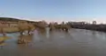
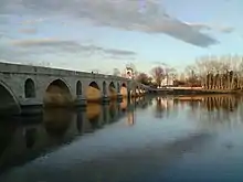
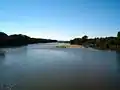 View from the river, Edirne.
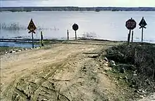
 The river viewed from Turkey. Greek land visible on the right.
Notes
| Wikimedia Commons has media related to Maritsa. |
- Preliminary Flood Risk Assessment, Ministry of Environment, Energy and Climate Change, p. 90
- inweb.gr
- Statistical Yearbook 2017, National Statistical Institute (Bulgaria), p. 17
- Georgiev, Vladimir Ivanov Georgiev. Introduction to the History of the Indo-European Languages (1981, p. 351).
- Florov, Nicholas; Florov, Irina. Three-thousand-year-old Hat. Michigan University.
- "The Plovdiv Project".
- Greek goddess Europa adorns new five-euro note, BBC, 10 January 2013
- Schramm, Gottfried (1981): Eroberer und Eingesessene. Geographische Lehnnamen als Zeugen der Geschichte Südosteuropas im ersten Jahrtausend n. Chr. Stuttgart: Hiersemann., pp.290f. Referenced in Carsten Peust, How Old Are the River Names of Europe?, Linguistik Online, 2015
- Evros: The immigrants' gateway. PBS.org, May 16, 2011.
- Turkish police bolster Greek border to stop migrants' return. 6 March 2020.
- Greece Defends Borders as Erdogan Opens the Gates: Live Updates. 1 March 2020.
- "Athens lodges demarche with Ankara over Evros dispute". ekathimerini.com. 22 May 2020.
- Environmental management of big riverine floods: the case of Evros River in Greece, Z. Nivolianitou, B. Synodinou
References
- "МАРИЦА (антично име: Хеброс, Хебър)". Българска енциклопедия А-Я (in Bulgarian). БАН, Труд, Сирма. 2002. ISBN 954-8104-08-3. OCLC 163361648.
| Authority control |
|---|