Markham River
The Markham River is a river in eastern Papua New Guinea. It originates in the Finisterre Range and flows for 180 km (110 mi) to empty into the Huon Gulf at Lae.
| Markham | |
|---|---|
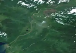 The Markham in its entirety, looking due West from near its source | |
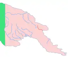 Location of the Markham River | |
| Location | |
| Country | Papua New Guinea |
| Physical characteristics | |
| Source | |
| • location | Finisterre Range, Papua New Guinea |
| • coordinates | 6°6′30″S 146°11′30″E |
| • elevation | 475 m (1,558 ft) |
| Mouth | |
• location | Huon Gulf, Papua New Guinea |
• coordinates | 6°44′20″S 146°58′5″E |
• elevation | 0 m (0 ft) |
| Length | 180 km (110 mi)approx. |
| Basin size | 12,766 km2 (4,929 sq mi) |
| Discharge | |
| • average | 1,260 m3/s (44,000 cu ft/s) |
| • maximum | 4,000 m3/s (140,000 cu ft/s) |
The river was named in 1873 by Captain John Moresby, R.N., in honour of Sir Clements Markham, then Secretary of the Royal Geographical Society.[1] A single-lane steel bridge, 1690 feet long – by far the longest bridge built in Papua until that time – was opened in January 1955.[2]
References
- Souter, Gavin (1963). New Guinea: The Last Unknown. Angus & Robertson. p. 77. ISBN 0-207-94627-2.
- Staff writers (31 January 1955). "N.G.'s Biggest Bridge Opened". The Age. Melbourne. Retrieved 19 July 2016 – via Newspapers.com.

This article is issued from Wikipedia. The text is licensed under Creative Commons - Attribution - Sharealike. Additional terms may apply for the media files.