Purari River
The Purari (also known as Puraari) is a river in that originates in the south central highlands especially in Kandep District of Enga Province of Papua New Guinea, flowing 470 kilometres (292 mi) though the Gulf Province to the Gulf of Papua. The Purari has a 33,670 km2 (13,000 sq mi) drainage basin and is the third largest river in Papua New Guinea.
| Purari | |
|---|---|
 The mouths of the Purari | |
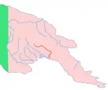 Location of the Purari | |
| Location | |
| Country | Papua New Guinea |
| Region | Gulf |
| Physical characteristics | |
| Source | |
| • location | Papua New Guinea |
| • coordinates | 6°24′S 144°15′E |
| • elevation | 1,240 m (4,070 ft) |
| Mouth | |
• location | Gulf of Papua, Papua New Guinea |
| Length | 470 km (290 mi) |
| Basin size | 33,670 km2 (13,000 sq mi) |
| Discharge | |
| • average | 2,360 m3/s (83,000 cu ft/s) |
| • maximum | 6,000 m3/s (210,000 cu ft/s) |
History
The headwaters of the river were charted in 1930 by Michael Leahy and Michael Dwyer.[1]
Geography
It is fed mainly by the Kaugel, Erave, Lai,[2] Tua and Pio rivers, starting just south of Mount Karimui at the junction of the Tua and Pio rivers, where it flows through a quite spectacular gorge before flowing out into the lowlands and delta country closer to the coast. River becomes tidal at substantial distance from the waters of Gulf of Papua. The Purari is a heavy muddy brown from silts washed down from the mountains, and rises and falls constantly depending on local rainfall.
Tributary
Purari River List of Tributaries by length.
- Wahgi River 243 km (151 mi)
- Erave River 223.6 km (138.9 mi)
- Tua River 200 km (120 mi)
- Kaugel River 112.6 km (70.0 mi)
- Zogi River 76 km (47 mi)
Biodiversity
The general area is heavy tropical jungle with high rainfall and abundant bird life.[3]
Economy
Along the river in various places there are small human populations, mostly subsistence villages. Dugout canoes are seen along the river from Wabo downstream, however population is sparse until you get closer to the coast where there are a few more villages.
Hydroelectric plant
The governments of Papua New Guinea and Government of Queensland have signed a Memorandum of Cooperation with PNG Energy Developments Ltd (PNG EDL) and Origin Energy (Origin) to support the potential development of a renewable hydro electricity project based on the Purari (Wabo Dam). [4]
See also
References
- Ian J. Willis An Epic Journey: The 1930 Expedition of Michael Leahy and Michael Dwyer Across New Guinea Via the Purari River University of Papua and New Guinea, 1969 - Papua New Guinea - 145 pages
- Meggitt, M. J. (1956). "The Valleys of the Upper Wage and Lai Rivers, Western Highlands, New Guinea". Oceania. 27 (2): 90–135. JSTOR 40373048.
- T. Petr The Purari — tropical environment of a high rainfall river basin: Tropical Environment of a High Rainfall River Basin Volume 51 of Monographiae Biologicae Springer Science & Business Media, Dec 6, 2012 - Science - 622 pages ISBN 9400972636 ISBN 9789400972636
- "PNG and Qld Governments support studies to progress a PNG renewable energy project for PNG and Qld". Media Release. Origin Energy. 15 September 2010. Retrieved 1 October 2010.
External links
- Pawitan, Hidayat; Jayawardena, A.W.; Takeuchi, K.; Lee, Soontak (2000). "Papua New Guinea: Purari Wara" (PDF). Catalogue of rivers for Southeast Asia and the Pacific, vol. III. UNESCO-IHP Regional Steering Committee for Southeast Asia and the Pacific. pp. 228–238. ISBN 4-9900653-0-1.