Matakatia
Matakatia is a northern coastal suburb of Auckland, in New Zealand. It is on the Whangaparaoa Peninsula about 43 kilometres (by road) north of the city centre.
Matakatia | |
|---|---|
Suburb | |
| Country | New Zealand |
| Local authority | Auckland Council |
| Electoral ward | Albany Ward |
| Population (2018) | |
| • Total | 1,977 |
| Tindalls Beach | Gulf Harbour | |
| (Polkinghornes Bay) |
|
Gulf Harbour |
| Manly | (Matakatia Bay) |
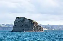
Kotanui Island, also called Frenchmans Cap, is a sharp triangular rock rising from the water about 1,000 metres offshore.[1]
History
A portage between Matakatia and Tindalls Beach allowed the movement of waka in the early 19th century.[2]
A road was developed through the area in 1938[3] and sections were sold the following year.[4]
The area to the north was Tindall's farm in the 1920s[5] and is now the suburb of Tindalls Beach.
Demographics
| Year | Pop. | ±% p.a. |
|---|---|---|
| 2006 | 1,548 | — |
| 2013 | 1,749 | +1.76% |
| 2018 | 1,977 | +2.48% |
| Source: [6] | ||
The statistical area of Tindalls-Matakatia, which includes Tindalls Beach to the north, had a population of 1,977 at the 2018 New Zealand census, an increase of 228 people (13.0%) since the 2013 census, and an increase of 429 people (27.7%) since the 2006 census. There were 723 households. There were 981 males and 999 females, giving a sex ratio of 0.98 males per female. The median age was 47.8 years, with 315 people (15.9%) aged under 15 years, 303 (15.3%) aged 15 to 29, 930 (47.0%) aged 30 to 64, and 429 (21.7%) aged 65 or older.
Ethnicities were 92.1% European/Pākehā, 6.1% Māori, 2.1% Pacific peoples, 5.6% Asian, and 2.1% other ethnicities (totals add to more than 100% since people could identify with multiple ethnicities).
The proportion of people born overseas was 32.3%, compared with 27.1% nationally.
Although some people objected to giving their religion, 49.2% had no religion, 40.1% were Christian, and 3.0% had other religions.
Of those at least 15 years old, 378 (22.7%) people had a bachelor or higher degree, and 192 (11.6%) people had no formal qualifications. The median income was $36,200. The employment status of those at least 15 was that 741 (44.6%) people were employed full-time, 276 (16.6%) were part-time, and 51 (3.1%) were unemployed.[6]
Notes
- "Drone operator captures incredible aerial footage of Auckland's Hibiscus Coast". Stuff. 2 November 2016.
- "Unknown title". Auckland-Waikato Historical Journal (66–72): 27. 1995.
- "Road Formation". New Zealand Herald. 26 March 1938. p. 5.
- "Houses and Land For Sale". New Zealand Herald. 1 April 1939. p. 7.
- Badham, Wallace (2009). The Iron-Bound Coast: Karekare in the Early Years. Oratia Books. p. 75. ISBN 9781877514012.
- "Statistical area 1 dataset for 2018 Census". Statistics New Zealand. March 2020. Tindalls-Matakatia (115400). 2018 Census place summary: Tindalls-Matakatia