Maungaraki
Maungaraki is a suburb of Lower Hutt City situated at the bottom of the North Island of New Zealand. The suburb is located on the western hills of the Hutt Valley with access to the area via State Highway 2 and offers extensive views of Wellington harbour and Matiu/Somes Island. It contains the largest suburban development on the Hutt Valley's western escarpment[2] that runs along the Wellington Fault.
Maungaraki | |
|---|---|
Suburb | |
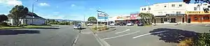 Maungaraki Baptist Church (left) and Maungaraki Shopping Centre (right) | |
| Country | New Zealand |
| Local authority | Lower Hutt City |
| Established | 1960s |
| Population (2013 [1]) | |
| • Total | 3,777 |
| Normandale | ||
|
|
Lower Hutt CBD | |
| Korokoro | Petone | Alicetown |
Maungaraki translated from Māori means: "mountains to the north",[3] this probably references the Māori pā to the south that once stood at Pito-one (Petone).
Community buildings
The suburb has a shopping centre, a church, and a community hall managed by the Maungaraki Community Association. The community hall building was relocated from the old NZ Railways works at Moera.
Maungaraki School is a full primary school formed on 19 April 1999 by a merger of Puketiro and Otonga schools.[4] Puketiro School opened in 1967 and was on the same site as Maungaraki School on Dowse Drive. Otonga School, which bordered Belmont Regional Park on Oakleigh Street, opened in 1977. Most of the land which Otonga School occupied is now private housing.
History
Housing increased rapidly in the area during the 1960s, at the time it was the largest local government subdivision in New Zealand.[5]
The main road through the suburb, Dowse Drive, is named after the Lower Hutt Mayor in the 1960s, Percy Dowse, who led the development of housing in Maungaraki. Most of the other roads in the suburb have tree names. Reese Jones Grove is named after Thomas and Myrtle Reese Jones, a Korokoro farming couple who sold a fair proportion of their land in Maungaraki to the Lower Hutt City Council in 1957.
Education
Maungaraki School is a co-educational state primary school for Year 1 to 8 students,[6][7] with a roll of 343 as of March 2020.[8]
External links
References
- Statistics New Zealand - 2013 Quick Stats Retrieved: 13 March 2017
- Boffa Miskell (April 2012). "Hutt Landscape Study 2012" (PDF). Hutt City Council. p. 26. Retrieved 11 February 2019.
- "1000 Māori place names". New Zealand Ministry for Culture and Heritage. 6 August 2019.
- "New Zealand Gazette 1998". www.gazette.govt.nz. Retrieved 8 March 2017.
- Te Ara: Encyclopaedia of New Zealand - Hutt Valley - central and west Retrieved on 13 January 2009
- "Maungaraki School Official School Website". maungaraki.school.nz.
- "Maungaraki School Education Review Office Report". ero.govt.nz. Education Review Office.
- "Maungaraki School Ministry of Education School Profile". educationcounts.govt.nz. Ministry of Education.
